
Billie Castle


Castle (Medieval), Corn Drying Kiln (Medieval), Enclosure(S) (Medieval)
Site Name Billie Castle
Classification Castle (Medieval), Corn Drying Kiln (Medieval), Enclosure(S) (Medieval)
Canmore ID 59638
Site Number NT85NE 1
NGR NT 85088 59645
NGR Description Centre
Datum OSGB36 - NGR
Permalink http://canmore.org.uk/site/59638


- Council Scottish Borders, The
- Parish Bunkle And Preston
- Former Region Borders
- Former District Berwickshire
- Former County Berwickshire
NT85NE 1 8506 5964.
(NT 8506 5964) Billie Castle (NR) (Remains of)
OS 6" map, (1957).
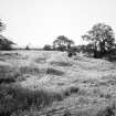
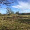
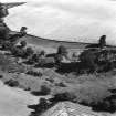
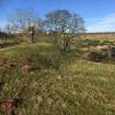
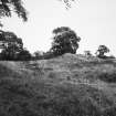
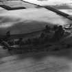
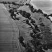
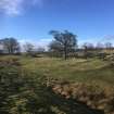
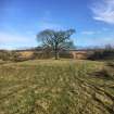
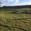
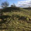
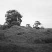
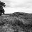
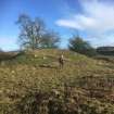
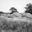
Billie Castle, dated by MacGibbon and Ross to their 'Third Period', 1400-1542, was destroyed by Hertford in 1544, and is now only recognisable by a few grass mounds. It stood on a grassy knoll, surrounded by a marsh.
D MacGibbon and T Ross 1889; RCAHMS 1915, visited 1908.
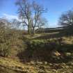
Billie Castle seems to have consisted of a strong quadrangular keep, about 50ft by 40ft, over walls 7 or 8ft thick. The building probably consisted of three storeys, the upper ones being reached by a narrow stone stair in the NW angle, some steps of which were visible about 40 years ago. The rounded towers stood at the two southernmost angles of the keep; the remains of one of them was seen (by Ferguson) 42 years ago (1858); there was an arrow-slit in the wall. All that now remains is part of the N wall, about 12 or 15ft in height, and a few detached fragments surrounded with rubbish. It was built with large, squared, red sandstone, and was surrounded by an outer wall, the foundations of which may yet be traced (J Ferguson 1900). It was well protected by a deep morass, defending three of the sides of the mound on which it stands. Billie Castle was the property of the Dunbars at the beginning of the 13th century, and passed to the Angus family in 1435; it was annexed by the Crown in 1540.
A Thomson 1908.
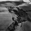
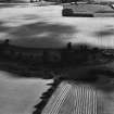
The remains of Billie Castle consist of a large, grass-grown mound 2.5m high in the N side of which can be seen two courses of masonry. Surrounding this is a ditch 12.0m wide and 1.5m deep with a causeway in the N. The S side of the moat opens on to what must have been a wide expanse of water which was retained in the E by a pond-bay.
Resurveyed at 1:2500.
Visited by OS (JP) 18 December 1972.
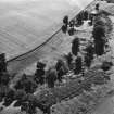
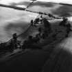
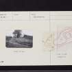
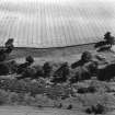
The remains of Billie Castle occupy a ditched enclosure of playing-card shape measuring 41m from E to W by 31m transversely. On the N, E and W sides there is a single ditch, 8m in width, and on the S side there are double ditches; these may have been flooded by means of earthen dams situated at the W and E ends of a natural gully immediately to the S of the enclosure. Within the enclosure there are the remains of a number of stone buildings, including what appear to be a tower and gate- house. To the E of the castle there are the remains of a kiln and two enclosures; the larger of the latter measures 42m by 22m over a low, stony bank, and each contains traces of a possible rectangular building; to the W there is a further enclosure.
RCAHMS 1980, visited 1979.
Field Visit (10 February 2020)
The location, classification and period of this site have been reviewed.
Sbc Note
Visibility: Upstanding building, which may not be intact.
Information from Scottish Borders Council
Sbc Note
Castle in ditched enclosure. Double ditches on south with earthen dams to W and E. Within enclosure are remains of stone buildings, tower, gatehouse.
Information from Scottish Borders Council

