
Upsettlington, Chapel Round


Earthwork (Period Unassigned)
Site Name Upsettlington, Chapel Round
Classification Earthwork (Period Unassigned)
Alternative Name(s) Chapel Site
Canmore ID 59554
Site Number NT84NE 9
NGR NT 8872 4683
Datum OSGB36 - NGR
Permalink http://canmore.org.uk/site/59554


- Council Scottish Borders, The
- Parish Ladykirk
- Former Region Borders
- Former District Berwickshire
- Former County Berwickshire
NT84NE 9 8872 4683.
(Name: NT 8885 4682) Chapel Round (NAT)
Site of Chapel (NR)
OS 6"map, (1957).
Chapel Round: A small enclosure in the centre of a large field, traditionally the burial place of the monks of Coldingham Priory and the general burial ground for Coldingham. A vast number of tombstones were removed about 40 years ago, and the ground afforested (Name Book 1858). The New Statistical Account (NSA) adds that a monastery stood in a part of Chapel Park (name: NT 887 467), marked by a few large stones and the superior richness of the soil, while the Rev J Stevenson of Ladykirk adds that the monastery, or rather convent, chapel was situated in that part of Chapel Park called Chapel Round.
Easson (I B Cowan and D E Easson 1976), however, states that there was no religious house in this vicinity and Fasti states that the church of Upsettlington stood in Chapel Park, the parishes of Upsettlington and Horndean being united after 1600 to form Ladykirk parish.
Robson states that all that remained of St Mary's Church of Upsettlington in 1896 was a block of stone halfway down the declivity to the lip of the Tweed. The church is mentioned in the 13th, 14th and 16th centuries.
NSA (G H Robertson: written 1834), 1845; Fasti Eccles Scot, H Scott et al ed. 1917; J Robson 1896.
NT 8872 4683. This is the most probable site for a church in this area, being a raised platform 1.0m in height. No signs of building foundations. A large block of stone, 1.5m by 1.0m was found as stated by Robson, but there is no evidence to link it with a church.
Visited by OS(JD) 18 January 1955.
A rectangular area of disturbed ground at NT 8872 4684 towards the N end of the platform mentioned in the previous field report is the most likely site of the chapel. The platform is possibly the extent of an associated burial ground, though no gravestones were found. Name not confirmed.
Surveyed at 1:2500.
Visited by OS(RD) 6 December 1971.
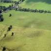
At this site there is a rectangular earthwork measuring 37m by 35m within a ditch, up to 8m broad, and an internal bank. Although it is said to be the site of the original parish church of Upsettlington, and tombstones were removed from it, the remains appear to be of secular character.
RCAHMS 1980, visited 1979.
Sbc Note
Visibility: This is an upstanding earthwork or monument.
Information from Scottish Borders Council

