Accessibility

Font Size

100% 150% 200%

Background Colour

Default Contrast
Close Reset

Ireland

Township (Period Unassigned)

Site Name Ireland

Classification Township (Period Unassigned)

Canmore ID 592

Site Number HU32SE 9

NGR HU 376 220

Datum OSGB36 - NGR

Permalink http://canmore.org.uk/site/592

Ordnance Survey licence number AC0000807262. All rights reserved.
Canmore Disclaimer. © Bluesky International Limited 2025. Public Sector Viewing Terms

Toggle Aerial | View on large map

Digital Images

Oblique aerial view centred on the township of Ireland, taken from the W.
Oblique aerial view centred on the township of Ireland, taken from the W.General oblique aerial view of Ireland, looking W.Oblique aerial view of Ireland, looking NE.Ireland, HU32SE 9, Ordnance Survey index card, RectoGeneral oblique aerial view of Ireland, looking SE.General oblique aerial view of Ireland, Sandwick, looking S.General oblique aerial view of Ireland, Sandwick, looking SE.Oblique aerial view centred on the township of Ireland, taken from the WNW.General oblique aerial view of Ireland, Sandwick, looking SE.Oblique aerial view of Ireland, looking NE.Oblique aerial view.Ireland, HU32SE 9, Ordnance Survey index card, RectoOblique aerial view centred on the township of Ireland, taken from the WNW.General oblique aerial view of Ireland, Sandwick, looking SSE.General oblique aerial view of Ireland, Sandwick, looking SSE.General oblique aerial view of Ireland, Sandwick, looking SSW.Oblique aerial view.

Administrative Areas

  • Council Shetland Islands
  • Parish Dunrossness
  • Former Region Shetland Islands Area
  • Former District Shetland
  • Former County Shetland

Archaeology Notes

HU32SE 9 centred on 376 220

See also:

HU32SE 3 3760 2192 Church; Burial-ground

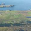
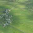
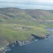
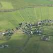
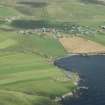
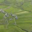
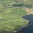
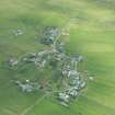
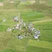
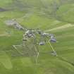
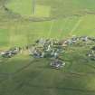
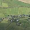
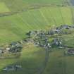
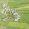
A township comprising eighteen roofed buildings, two unroofed structures and eight enclosures is depicted on the 1st edition of the OS 6-inch map (Orkney & Shetland (Shetland) 1882, sheet lxii). Three partially roofed buildings, twenty roofed buildings and four enclosures are shown and on the current edition of the OS 1:10000 map (197).

Information from RCAHMS (SAH) 12 June 2001

References

MyCanmore Image Contributions


Contribute an Image

MyCanmore Text Contributions