
Pricing Change
New pricing for orders of material from this site will come into place shortly. Charges for supply of digital images, digitisation on demand, prints and licensing will be altered.
Camp Tops


Cord Rig (Prehistoric)
Site Name Camp Tops
Classification Cord Rig (Prehistoric)
Canmore ID 59014
Site Number NT81NE 44
NGR NT 85957 18062
NGR Description From NT 8590 1805 to NT 8605 1806
Datum OSGB36 - NGR
Permalink http://canmore.org.uk/site/59014


- Council Scottish Borders, The
- Parish Morebattle
- Former Region Borders
- Former District Roxburgh
- Former County Roxburghshire
NT81NE 44 from 8590 1805 and 8605 1806
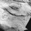
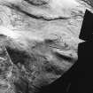
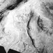
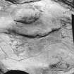
Extensive traces of cord rig are visible, on oblique aerial photographs (D Harding, University of Edinburgh), over the moderately steep to steep slopes at the N end of a long ridge, immediately downhill from the fort on Camp Tops. The cord rig could be seen over an area measuring some 100m from E to W by 50m but at the time of visit it was not clearly visible on the ground. The cord rig has been cut by the sunken route of a trackway climbing up the E side of the ridge and subsequent cultivation of the hillside has left a plough scar just to the N of Camp Tops fort (NT81NE 8) (at NT 8603 1806). The relationship between the rig and the fort is uncertain at this point although similar rig (NT81NE 8) appears to be covered by the counterscarp bank of outer rampart.
Information from RJ Mercer (University of Edinburgh) 15 March 1986
RCAHMS MS 2598. No. 46/595
Sbc Note
Visibility: This site is visible as a cropmark.
Information from Scottish Borders Council

