
Pricing Change
New pricing for orders of material from this site will come into place shortly. Charges for supply of digital images, digitisation on demand, prints and licensing will be altered.
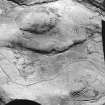
Hayhope Knowe


Cord Rig (Prehistoric)
Site Name Hayhope Knowe
Classification Cord Rig (Prehistoric)
Canmore ID 59013
Site Number NT81NE 43
NGR NT 859 176
NGR Description NT 859 176 to NT 860 176
Datum OSGB36 - NGR
Permalink http://canmore.org.uk/site/59013


- Council Scottish Borders, The
- Parish Morebattle
- Former Region Borders
- Former District Roxburgh
- Former County Roxburghshire
NT81NE 43 859 176 to 860 176
Cord rig
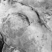
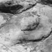
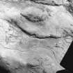
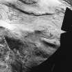
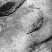
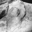
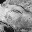
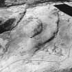
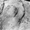
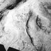
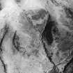
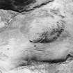
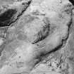
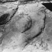
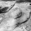
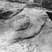
Oblique aerial photographs (D Harding, University of Edinburgh; RCAHMS) record extensive traces of cord rig over the predominantly moderate upper slopes of the spur of Hayhope Knowe (from NT 8599 1768 to 8604 1761, NT 8692 1763 and NT 8594 1755. The cord rig, on an NW to SE orientation, is observable over both the N- and SW-facing slopes around the palisaded-enclosure crowning the spur (46/604). There are two principal areas of cultivation visible; that on the N of the spur covers an area measuring up to 80m by 140m overall with a similar sized patch lying on the SW. The cord rig, unquestionably, overlies the double palisade on both the N and S sides of the enclosure but does not continue into the interior. It also survives immediately W of the terminal of the apparently unfinished rampart, thus suggesting its antecedence. Similarly it seems to overlie the line of the single palisade. The cord rig, therefore, post-dates the abandonment and decay of the palisaded elements of Hayhope Knowe but, in turn, probably pre-dates the unfinished rampart.
Over the E part of the spur a further significant relationship may be observed between cord rig, adopting a N to S orientation, and a hollow-way climbing up the NE side of the spur which overlooks the Hayhope Sike. The hollow-way is almost 1m deep and, in places, bifurcates as it climbs the spur. The cord rig extends over the lip of the more southerly route on its SW side thus post-dating the abandonment of this alignment as a track. The more northerly route, may, however, have remained in use and could conceivably formed a boundary to the cultivation. The suggestion must be that the cord rig post-dates at least one phase of local trackway use.
The presence of cord rig over the hilltop is integral to understanding the evolution of the landscape in which the settlement is set. Not only does the cultivation post-date the abandonment and decay (either naturally or through human agencies) of the double and single palisades but it is also superimposed upon a long-lived, heavily used trackway and, in this, perhaps reflects a shift from an emphasis on a pastoral to a more agrarian economy.
Information from RJ Mercer (University of Edinburgh) 16 March 1986.
RCAHMS MS 2598. No 46/603
Sbc Note
Visibility: This is an upstanding earthwork or monument.
Information from Scottish Borders Council

