
Elm Knowe


Enclosure (Period Unassigned)
Site Name Elm Knowe
Classification Enclosure (Period Unassigned)
Canmore ID 58990
Site Number NT81NE 22
NGR NT 85871 17265
NGR Description From NT 85898 17265 to NT 85857 17245
Datum OSGB36 - NGR
Permalink http://canmore.org.uk/site/58990


- Council Scottish Borders, The
- Parish Morebattle
- Former Region Borders
- Former District Roxburgh
- Former County Roxburghshire
NT81NE 22 from 85898 17265 to 85857 17245
(NT 85871 17265) Earthwork (NR)
OS 6" map, (1962).
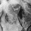
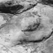
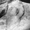
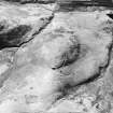
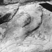
There are slight traces of what may have been a fort on the summit of Elm Knowe. The hill-top has been cultivated at some time, but on the SE, facing the col, there can be seen a curved bank now only 6' thick and 6" high with a suggestion of an external quarry-ditch. At the apex of the curve, in the natural position for an entrance, there is a gap 10' wide. A crest-line on the N flank of the hill may represent the extension of the bank on that side.
RCAHMS 1956, visited 1948.
All that remains are traces of a scarp all round the perimeter, varying from 0.2m high on the S to 1.0m high on the N. The entrance can be traced in the E side, some 3.0m wide. The overall dimensions are approximately 65.0m NW-SE by 47.0m. The earthwork does not appear to have been of a defensive nature, rather that of a small settlement or even a simple enclosure.
Visited by OS (JLD) 24 August 1960.
No change to previous field report.
Surveyed at 1:2500.
Visited by OS (RD) 27 June 1968.
The remains of this small settlement are as described in the report of 24 August 1960.
Visited by OS (TRG) 9 August 1976.
Scheduled as settlement.
Information from Historic Scotland, scheduling document dated 22 August 1991.
This enclosure occupies the crown of a broad, blunt spur projecting NW from The Bank into the valley of the Kelsocleuch Burn reminiscent of the settlement (46/603) on Hayhope Knowe on the next spur to the N. As at Hayhope Knowe the approaches to the site are along very gentle slopes on the neck of the spur. Unlike at the former site, there are no traces of cultivation on the slopes of the spur which are moderately steep on the S becoming steep elsewhere. The RCAHMS (1956) noted that the hill-top had been cultivated at some time.
The enclosure measures 72m from NW to SE by 47m over the slight traces of a low bank which has largely been reduced to little more than a shallow scarp standing up to 0.2m in height. Where best-preserved, flanking a 3m wide entrance on the SE of the spur, the bank measures 1.5m in width and stands up to 1m in height. The interior is generally featureless, although two shallow depressions, each measuring 4m in diameter, in the NE may represent house-stances.
A very low earth bank, no more than 0.1m high, stretches SW across the very gentle approaches to the enclosure and above the head of the Elm Sike.
Information from RJ Mercer (University of Edinburgh) 15 March 1986
RCAHMS MS 2598. No. 46/608
Sbc Note
Visibility: This is an upstanding earthwork or monument.
Information from Scottish Borders Council

