
Pricing Change
New pricing for orders of material from this site will come into place shortly. Charges for supply of digital images, digitisation on demand, prints and licensing will be altered.
Hayhope Knowe


Cord Rig (Prehistoric), Enclosure (Period Unassigned), Palisaded Settlement (Period Unassigned)
Site Name Hayhope Knowe
Classification Cord Rig (Prehistoric), Enclosure (Period Unassigned), Palisaded Settlement (Period Unassigned)
Canmore ID 58985
Site Number NT81NE 18
NGR NT 85980 17603
NGR Description From NT 86015 17663 to NT 85897 17573
Datum OSGB36 - NGR
Permalink http://canmore.org.uk/site/58985


- Council Scottish Borders, The
- Parish Morebattle
- Former Region Borders
- Former District Roxburgh
- Former County Roxburghshire
NT81NE 18 from 86015 17663 to 85897 17573
(NT 85980 17603) Settlement (NR)
OS 6" map, (1962).
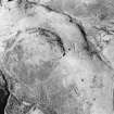
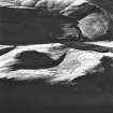
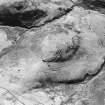
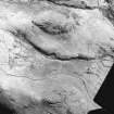
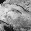
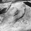
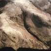
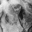
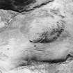
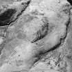
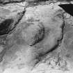
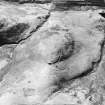
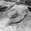
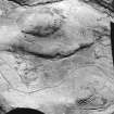
The palisaded settlement on Hayhope Knowe is situated well back from the W end of the hill-top. It was first identified from air photographs by Dr Steer in 1946 and confirmed by excavation in 1947. A larger scale excavation was carried out by Mrs Piggott in 1949. This showed that it was occupied for a short time, probably in the 1st century BC, and not at any subsequent date. It consists of an oval enclosure formed by twin palisades 5' apart, traces of which are clear among the short coarse pasture, measuring 285' x 165' containing possibly sixteen timber-framed huts between 36' and 42' in internal diameter. The annular grooves representing parts of twelve of these huts may be seen on the ground. The settlement was surrounded at a distance varying between 20' and 40' by an outlying palisade, presumably to form a corral for cattle; this was mostly obliterated by a bank and ditch, begun to strengthen the defences but abandoned before completion.(See RCAHMS 1956 plan, fig.451) Three of the huts were completely excavated; their foundations were found to consist of two shallow concentric trenches about 6' apart. The outer trench presumably retained the base of the hut wall while the inner trench seems to have held the main roof supports. Finds from the excavations include pottery fragments, a whorl, and an iron spearhead which may be a Hallstatt import. (A Ritchie 1970). They are now in the NMAS.
RCAHMS 1956, visited 1949; C M Piggott 1951; R W Feachem 1963; 1965; 1966; Proc Soc Antiq Scot 1952 (Donations).
This palisaded settlement is as described.
Surveyed at 1:2500.
Visited by OS (JLD) 26 August 1960 and (RD) 27 June 1968.
No change to previous field report.
Visted by OS (IA) 17 July 1973.
This palisaded settlement remains as described by the previous authorities.
Revised at 1:10 000.
Visited by OS (TRG) 9 August 1976.
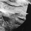
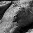
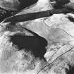
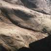
This palisaded settlement, augmented by the apparently unfinished rampart of an enclosure or fort, occupies the crown of a broad, blunt spur projecting westwards from White Knowe into the valley of the Kelsocleuch Burn. The site is positioned to control the only approach, which is from the E by a neck of ground dropping down very gently from White Knowe. To the N of the approach, the slope, down to the Hayhope Sike, is moderately steep and displays extensive traces of cord rig (NT81NE 18) and contour cultivation (NT81NE 36 and possibly NT81NE 113). The slopes on the S side of the spur become steep to very steep at the end of the spur. As at the neighbouring site of Camp Tops (NT81NE 8), the site commands a complex of trackways climbing White Knowe from the valley to the N, and ultimately up onto Windy Gyle and The Border.
The palisaded settlement measures about 90m from E to W by 52m within a double palisade. A further single palisade-trench is traceable between 5.4m and 6m in front of the double palisade, on the N side of the spur. This, in turn, lies immediately behind a rampart which appears unfinished as traces are sporadic along the S side of the spur an non-existent at the W end. Settlement is almost exclusively confined within the double palisade, and traces of cord rig cultivation clearly overlie this feature on the N side.
The site was first identified in 1946, by Steer from air photographs, and confirmed by excavation in 1947. Two years later C. M. Piggott conducted more extensive excavations, examining both the E and W entrances of the double palisade with sections elsewhere to confirm its course. She also examined the E entrance through the rampart and placed a section across its NW end, picking up the line of the single palisade-trench behind. In the interior, three circular buildings were completely excavated. The following account of the site draws on the excavation evidence to enlarge upon that available from survey alone.
The defences
From the brief description of the site above, it is apparent that there are three defensive components present at Hayhope Knowe. Even with the benefit of excavation the relationship between these elements cannot be readily resolved and any attempts at interpretation depend on the relationship of the cord rig, observed over the hilltop, with the defensive sequence.
Double palisade
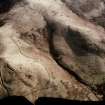
The innermost component of the site is formed by an enclosure defined by a double palisade-trench around the crown of the spur. Enclosing an area measuring about 90m by 52m, the palisades are visible on the surface as trenches on the E and W ends and over parts of the N and NE sides. Further traces noted on the SW side in 1949, were not visible at the time of survey. The two trenches are approximately 2m apart, centre to centre. Excavation established the line of the palisades along the S side of the spur. On excavation, the trenches were observed to measure between 0.35m and 0.4m in width and between 0.4m and 0.5m in depth. Uprights of alder, with willow also present were set in the trench, and had in instances been burnt there, at uneven centres ranging from 0.3m to 0.6m. Over the exposed areas there were 16 uprights every 5m. Despite the arid circumstances of the excavation, post-pipes, averaging 0.15m to 0.25m in diameter, were visible C.M. Piggott calculated that 1600 such posts would be required to for the construction of the double palisade (Piggott, 1948-9, 198-9).
The palisaded enclosure has two entrances, at the E and W ends, both of which were excavated by Piggott. At both, the outer palisade loops round, returning as the inner element. The E entrance proved to be more elaborate than the W. It measured 2.9m in width as opposed to 2.25m in width, and a 'drop-slot' was also present.
Any spoil from the palisade-trenches was probably deposited on the intervening berm, though any bank thus formed would be insubstantial. Rather the double palisade would have supported an elevated walkway, perhaps with a breastwork, as was suggested by Piggott. Such a suggestion would, of course, have inflationary implications for any figures for timber consumption required.
Single palisade
On the N side of the spur there are traces of a further single palisade set from 5.4m to 6m in front of the double palisade. This palisade splays out to 12m at the E entrance to the original enclosure, perhaps suggesting that both the double and single palisades were contemporaneous forming a box rampart and counterscarp. On excavation the palisade-trench was found to be about 0.5m wide and 0.5m deep. Over the observed lengths of this palisade, posts of alder, averaging 0.25m in diameter, were set at an average of 0.4m apart. Piggott calculated that 1000 such posts would have been required to construct the whole circuit. Excavation revealed a 5.3m wide entrance on the NE side of the enclosure (almost on alignment with the double palisade entrance). No gate-mechanisms were retrieved through excavation. The contrasting widths between the double and single palisade entrances, 5.3m as opposed to 2.9m, as well as the variation between single and double palisades, may suggest contrasting function, perhaps the wider entrance was for the admission of animals whilst the narrower one served to exclude them. No trace of this feature was visible on the ground, or exposed through excavation, on the S side, or W end.
Rampart
What appears to the modern eye as an unfinished earthwork forms the most visible aspect of the site. Where best preserved, on the E end, the rampart comprises a bank measuring 4m in thickness with an intermittent and irregular external ditch. On the N side, it comprises a near continuous bank, either immediately outwith or overlying the outer edge of the single palisade-trench. Again there is a shallow external ditch which excavation at the NW terminal revealed to be 1.75m wide but only 0.6m deep though survey indicates that it is clearly wider and deeper over the NE side of the spur. Yet on the S side, the bank can only be traced sporadically with breaks between 14m and 20m long. There is no trace of a bank or ditch over the W end. The character of this enclosure reflects the strategic requirements of the topography. The rampart was first thrown up across the main approach from the neck of the spur and then above the moderately steep approaches from the N whereas the very steep slopes on the W and SW sides were left unprotected whilst construction commenced over the slightly more vulnerable S side of the spur. Whether this reflects hasty erection, in response to a threat or piecemeal construction over several seasons, is open to discussion. Further testimony to the unfinished character of the rampart was revealed by the excavation of the entrance on the NE side which produced no evidence of a gate-passage revetment or any gate-furniture.
Regrettably the 1949 excavations failed fully to address the stratigraphical relationship between the single palisade-trench and the rampart. Consequently Piggott ended her excavation with relatively minimal and ambiguous evidence for the stratigraphical relationship between these elements and could only conclude:
'unfortunately the point of junction between the inner side of the rampart and the palisade-trench so exactly correspond that it was impossible to discover from the section whether this palisade-trench may have pre-dated the earthwork. But the two seemed so closely related on the ground, it is reasonable to regard them as chronologically related too ' (Piggott, 1948-9, 56).
Although the single palisade could form the rear revetment to the rampart, no corresponding front revetment was found in either excavation trench and such a feature alone would be unusual if not impractical. Moreover, whilst the palisade-trench appears to correspond with the rear margin of the rampart in the NW cutting, and from survey evidence over much of the N side, this is not the case at the entrance on the NE. Here, according to Piggott's plan, the palisade-trench does not follow the rampart's rear margin but stands well over 0.5m to the rear of the talus. Furthermore the palisade entrance is also wider than and not exactly aligned on the rampart entrance. For the short length where the palisade-trench was revealed to the E of the entrance it approaches the bank at an awkward angle. Unfortunately there is no surface trace of the single palisade-trench over the S half of the spur, but assuming it is roughly concentric to, and lying about 6m outside, the double palisade, then it must be destroyed by construction of the bank and ditch on that side.
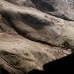
Cord rig
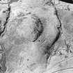
Oblique aerial photographs (D Harding, University of Edinburgh; RCAHMS) record extensive traces of cord rig over the predominantly moderate upper slopes of the spur of Hayhope Knowe (from NT 8599 1768 to 8604 1761, NT 8692 1763 and NT 8594 1755. The cord rig, on an NW to SE orientation, is observable over both the N- and SW-facing slopes around the palisaded-enclosure crowning the spur (46/604). There are two principal areas of cultivation visible; that on the N of the spur covers an area measuring up to 80m by 140m overall with a similar sized patch lying on the SW. The cord rig, unquestionably, overlies the double palisade on both the N and S sides of the enclosure but does not continue into the interior. It also survives immediately W of the terminal of the apparently unfinished rampart, thus suggesting its antecedence. Similarly it seems to overlie the line of the single palisade. The cord rig, therefore, post-dates the abandonment and decay of the palisaded elements of Hayhope Knowe but, in turn, probably pre-dates the unfinished rampart.
Over the E part of the spur a further significant relationship may be observed between cord rig, adopting a N to S orientation, and a hollow-way climbing up the NE side of the spur which overlooks the Hayhope Sike. The hollow-way is almost 1m deep and, in places, bifurcates as it climbs the spur. The cord rig extends over the lip of the more southerly route on its SW side thus post-dating the abandonment of this alignment as a track. The more northerly route, may, however, have remained in use and could conceivably formed a boundary to the cultivation. The suggestion must be that the cord rig post-dates at least one phase of local trackway use.
The presence of cord rig over the hilltop is integral to understanding the evolution of the landscape in which the settlement is set. Not only does the cultivation post-date the abandonment and decay (either naturally or through human agencies) of the double and single palisades but it is also superimposed upon a long-lived, heavily used trackway and, in this, perhaps reflects a shift from an emphasis on a pastoral to a more agrarian economy.
Internal Structures
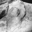
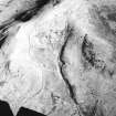
Settlement evidence is almost exclusively restricted to within the circuit of the double palisaded enclosure. In total eighteen structures have been recorded. Two thirds of the structures appear to be quite clearly ranged along either side of a 'street' running approximately E to W along the spine of the spur between the two entrances of the enclosure. A further tier of five structures lies behind those at the S side of 'the street'. Six structures lie to the N of the 'street'.
On entering the enclosure from the E, the first structure reached is Piggott's House I on the N side of the 'street'.
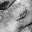
House (1) (Piggott I) is a double ring-groove house which was fully excavated in 1949 and of which no surface remains are now visible. From the excavation account it was an oval structure measuring 10.5m from E to W by 8.9m with the entrance apparently on the N. There was a central hearth.
House (2) (Piggott II) lies immediately to the W. It is unexcavated and measures 13m by 11m overall and the entrance lies somewhere on the N or NE. Diverse elements are present, perhaps suggestive of two phases of activity. Eccentrically placed within a single ring-groove, averaging 12.5m in diameter, there is a low horseshoe shaped bank, open to the E which may form a central platform to a ring-ditch which is only traceable on the S.
House (3) comprises two short arcs of narrow grooves which may be the remains of a house of up to 8m in diameter.
House (4) consists of a small scoop set into the slope with an arc of narrow ring-groove around its leading edge on the S.
House (5) (Piggott III) lies 3m to the W and was excavated in 1949. It comprises a single ring-groove at the rear of a W-facing scooped platform up to 6.5m in diamter. The entrance is probably on the W.
House (6) is represented by a slight circular depression no more than 3m across. Later cord-rig cultivation may account for the almost total destruction of this possible structure.
Returning E along the S side of the 'street':
House (7) (Piggott IV) comprises a single ring-groove house with a central depression measuring 9m in diameter.
House (8) (Piggott V), lying about 2.8m to the E, is very similar, comprises a single ring-groove house measuring about 9m in diameter with a central depression.
House (9) (Piggott VI) lies about 6m to the E and comprises a double ring-groove house measuring up to 12m in diameter. It comprises a platform levelled into the slope with a central depression. A ring-groove is visible around the back of the platform at the base of a slight scarp. On the N through to NE are traces of a low embankment beyond which is a short stretch of a second ring-groove.
House (10) lies about 6m to the E and is little more than a W-facing platform up to 8m in diameter.
House (11) (Piggott VII) has been excavated. It comprises an oval structure of double ring-groove type, measuring 11.3m by 10.5m. The entrance is on the S. Burnt post-cores were found in the outer groove along with pottery (one simple rounded rim) and an iron spearhead.
House (12) (Piggott VIII) is adjacent to the E and lies nearest the entrance. It measures 12m in diameter over a single ring-groove.
Returning W from the entrance along the second tier of structures to the S of the 'street'.
House (13) is apparently superimposed upon the double palisade and measures 6m in diameter over a ring groove which survives only on the N side.
House (14) (Piggott XII) comprises a diminutive platform with traces of a ring-groove along its rear edge. It measures up to 6m in diameter. The fairly positive apron around the S side, or front, of this structure appears to overlie traces of cord rig that, in turn, are superimposed upon the double palisaded rampart.
House (15) (Piggott XI) is levelled into the slope on the N where there is traces of a recut ring-groove. It measures about 10m in diameter and the entrance lies on the S.
House (16) (Piggott X) is a ring-groove house with traces of a slight internal bank. It measures 8m in diameter and the entrance is, again, probably on the S.
House (17) is represented by a slight circular depression measuring about 4m in diameter and may be the residual traces of a house.
On the NW side of the spur, and lying against, and apparently integral to the innermost palisade, there is a further structure (18) defined by a ring-groove measuring no more than 4m in diameter.
The relationship between the settlement evidence with that of the sequence of enclosure is minimal. The small ring-groove structure associated with the inner circuit of the double palisade is not, necessarily, a domestic feature and lies away from the 'street'. Whilst house (13) appears to overlie the double-palisade, it is again not an integral part of the 'street' but lies on a second 'tier' on the slope to the S. The relationship between the houses and the cord rig is also negligible with only the doubtful remains of house (6) lying beneath the cultivation. In turn the apron of house (14), again not forming part of the 'street', does overlie the cultivation.
Information from RJ Mercer (University of Edinburgh) 16 March 1986
RCAHMS MS 2598. No. 46/603
Note (14 September 2015 - 25 October 2016)
This fortification crowns the crest of Hayhope Knowe, which forms the E spur of White Knowe above Kelsocleuch. Its defences comprise three elements, namely a double palisade, a single palisade, and a rampart and ditch; the sequence of their construction, however, is unknown, and though the single palisade trench, which is not visible on the ground, is set immediately to the rear of the rampart, Mrs C M Piggott was unable to unravel their relationship in the limited excavations she conducted in 1949. Nevertheless, as Roger Mercer observed in 1986, the palisade is set a little to the rear of the rampart at the entrance through the earthwork on the E, and the gap in the palisade, the worn hollow into the interior, and the gap in the bank are not strictly aligned, perhaps indicating that the palisade was once a free-standing enclosure. Oval on plan, this enclosure measures about 110m from E to W by 65m transversely (0.55ha), though its course is entirely masked by the rampart around most of the circuit, and by cord rig cultivation at the open W end. This missing sector of the earthwork, and the discontinuous character of the external ditch, which where tested on the NW was 1.8m wide by 0.6m deep, has been interpreted as an unfinished replacement of the palisade, though the symmetry of the enclosure and the way the relatively slight rampart increases in size towards the entrance on the E might indicate that the earthwork is as its builders intended it. Within the interior there are traces of an inner enclosure defined by twin palisade trenches set about 1.5m apart. Also oval on plan, and set roughly concentrically within the rampart, this measures internally 85m from E to W by 50m transversely (0.34ha) and is pierced at either end by an entrance where the palisade trenches return and unite. Traditionally reconstructed as simply two close-set fences, there is no reason why this should not be the foundation for a more sophisticated superstructure, in effect some form of a timber rampart, and should be regarded as a fortification in its own right. Around the N and W flanks, and to a lesser extent on the SE, the two palisade trenches and the low bank between them are overridden by traces of cord rig, but within this halo there are extensive traces of at least fourteen timber round-houses, including double ring-grooves, platforms encircled by single grooves and several small platforms. These are mainly enclosed within the double palisade trenches, though one small platform on the SE is cut through the perimeter. In addition to excavating trenches across the perimeter, Mrs Piggott dug three of the round-houses, recovering a relatively large quantity of coarse pottery, a clay spindle whorl and an iron spearhead, the latter compared at the time with late Iron Age examples in southern England; subsequently Colin Burgess suggested that it might be a rather earlier Hallstatt import (Ritchie 1970), though it is probably too corroded to be dated with any confidence.
Information from An Atlas of Hillforts of Great Britain and Ireland – 25 October 2016. Atlas of Hillforts SC3440
Sbc Note
Visibility: This is an upstanding earthwork or monument.
Information from Scottish Borders Council

