
Pricing Change
New pricing for orders of material from this site will come into place shortly. Charges for supply of digital images, digitisation on demand, prints and licensing will be altered.
Thorntonloch Bridge


Enclosure (Period Unassigned)
Site Name Thorntonloch Bridge
Classification Enclosure (Period Unassigned)
Canmore ID 58964
Site Number NT77SW 58
NGR NT 74990 74210
Datum OSGB36 - NGR
Permalink http://canmore.org.uk/site/58964


- Council East Lothian
- Parish Innerwick (East Lothian)
- Former Region Lothian
- Former District East Lothian
- Former County East Lothian
NT77SW 58 NT 74990 74210
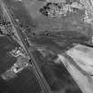
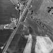
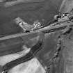
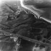
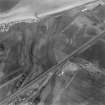
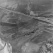
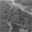
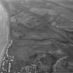
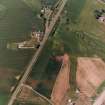
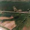
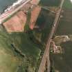
Aerial photography has revealed the cropmark of a roughly circular enclosure, with a diameter of about 25m, 100m S of Thorntonloch.
Information from RCAHMS (KB) 15 March 1999.
Aerial Photographic Transcription (11 December 1997)
An aerial transcription was produced from oblique aerial photographs. Information from Historic Environment Scotland (BM) 31 March 2017.
Aerial Photographic Transcription (20 October 2008)
Magnetometry (21 September 2015 - 9 October 2015)
NT 75522 74186, NT 74986 74179, NT 74642 74325, NT 74232 74563, NT 74212 74636, NT 73518 74821, NT 72572 74887, NT 71719 74047, NT 71527 73617, NT 71070 73313, NT 70614 73491, NT 69265 73200, NT 69046 72929, NT 69079 72631 and NT 69245 72354 A detailed gradiometer survey was conducted, 21 September – 9 October 2015, along the proposed route of the onshore cable connecting the Neart na Gaiothe Offshore Wind Farm from landfall at Thorntonloch Burn with the substation at Crystal Rig II Wind Farm (c12.4km).
The work identified several enclosure ditches that correspond with known cropmark sites, identified as prehistoric and early historic from aerial photographs, as well as the possible northern extent of a known promontory fort at Thortonloch.
A number of previously unknown linear and curvilinear ditches were identified across the cable route, with one rectilinear feature, possibly a former building, to the W of Innerwick. An area to the S of Skateraw had several anomalies of possible archaeological interest that probably relate to quarrying activity recorded at this location. Other features identified were a large number of drainage ditches, evidence of ploughing, areas of increased magnetic response and numerous trends of uncertain origin.
Archive: East Lothian Council Archaeology Service and NRHE
Funder: Neart na Gaoithe Offshore Wind Ltd
Dan Atkinson and Andrew Bicket – WA Heritage
(Source: DES, Volume 18)
OASIS ID: waherita1-230841

