
Pricing Change
New pricing for orders of material from this site will come into place shortly. Charges for supply of digital images, digitisation on demand, prints and licensing will be altered.
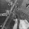
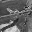
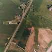
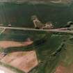
Thorntonloch


Cropmark(S) (Period Unknown), Ring Ditch (Period Unassigned), Track (Period Unassigned)
Site Name Thorntonloch
Classification Cropmark(S) (Period Unknown), Ring Ditch (Period Unassigned), Track (Period Unassigned)
Canmore ID 58937
Site Number NT77SW 33
NGR NT 74876 74019
Datum OSGB36 - NGR
Permalink http://canmore.org.uk/site/58937


- Council East Lothian
- Parish Innerwick (East Lothian)
- Former Region Lothian
- Former District East Lothian
- Former County East Lothian
NT77SW 33 NT 74876 74019
Aerial Photographic Transcription (11 December 1997)
An aerial transcription was produced from oblique aerial photographs. Information from Historic Environment Scotland (BM) 31 March 2017.
Aerial Photographic Transcription (12 May 1997 - 11 December 1997)
An aerial transcription was produced from oblique aerial photographs. Information from Historic Environment Scotland (BM) 31 March 2017.
Aerial Photographic Transcription (20 October 2008)
Aerial Photographic Transcription (6 October 2015)

