
Dunglass, 'french Camp'


Artillery Fortification (16th Century)
Site Name Dunglass, 'french Camp'
Classification Artillery Fortification (16th Century)
Canmore ID 58903
Site Number NT77SE 6
NGR NT 7635 7170
Datum OSGB36 - NGR
Permalink http://canmore.org.uk/site/58903


- Council East Lothian
- Parish Oldhamstocks (East Lothian)
- Former Region Lothian
- Former District East Lothian
- Former County East Lothian
NT77SE 6 7635 7170
(NT 7635 7170) French Camp (NR)
OS 6" map (1959)
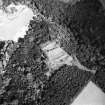
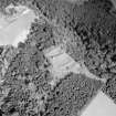
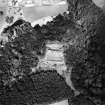
The so-called 'French Camp' was really an English fort constructed and used during the occupation of Haddington in 1548-9. By the Treaty of Boulogne in 1550 it was to be handed over to the Scots and by them destroyed.
The earthworks consist of ramparts and deep ditches enclosing a triangular area on the edge of the plateau overlooking Dunglass.
Towards the south side is a high rectangular mound with a summer-house dated 1718 at one end and an excavated bowling-green to the west. The ditches are deepest on the side next the steep slope and slight on the opposite side where they were most necessary if required for defence. The place is much cut up with modern walks.
RCAHMS 1924
The fort is generally as described by the RCAHMS. The SE sector is largely obscured by fir trees.
Revised at 25".
Visited by OS (EGC) 19 April 1966.
Field Visit (27 June 1913)
The earthworks known as the ‘French Camp’ near Dunglass House, Oldhamstocks consist of ramparts and deep ditches enclosing a triangular area (fig. 118) on the edge of the plateau overlooking Dunglass. Towards the south side is a high rectangular mound with a summerhouse dated 1718 at one end and an excavated bowling green to the west. The ditches are deepest on the side next the steep slope and slight on the opposite side where they were most necessary if required for defence. The place is much cut up with modern walks.
The so-called 'French Camp’ was really an English Fort constructed and used during the occupation of Haddington in 1548-9 (1). By the Treaty of Boulogne (1550) it was to be handed over to the Scots and by them destroyed (2).
RCAHMS 1924, visited 27 June 1913.
(1) Introd. p. xxx. Illustrations of the Reign of Queen Mary pp. 47, 52; (2) Foedera xv., p. 215, where it is called ‘Douglas.’.

