
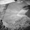
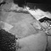
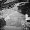
Springfield


Enclosure (Period Unassigned)(Possible), Pit(S) (Period Unassigned)(Possible)
Site Name Springfield
Classification Enclosure (Period Unassigned)(Possible), Pit(S) (Period Unassigned)(Possible)
Canmore ID 58900
Site Number NT77SE 57
NGR NT 75286 70746
Datum OSGB36 - NGR
Permalink http://canmore.org.uk/site/58900


- Council East Lothian
- Parish Oldhamstocks (East Lothian)
- Former Region Lothian
- Former District East Lothian
- Former County East Lothian
NT77SE 57 NT 75286 70746
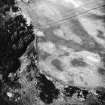
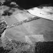
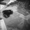
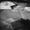
Aerial Photographic Transcription (1 February 2019)
An interpretative transcription, or mapping, of information on oblique aerial photographs was produced on 1 February 2019.

