
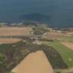
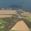
Dunglass


Collegiate Church (15th Century)
Site Name Dunglass
Classification Collegiate Church (15th Century)
Alternative Name(s) Collegiate Church Of The Blessed Virgin Mary; Chapel Of St Mary Of Dunglass
Canmore ID 58881
Site Number NT77SE 4
NGR NT 76657 71896
Datum OSGB36 - NGR
Permalink http://canmore.org.uk/site/58881


First 100 images shown. See the Collections panel (below) for a link to all digital images.
- Council East Lothian
- Parish Oldhamstocks (East Lothian)
- Former Region Lothian
- Former District East Lothian
- Former County East Lothian
NT77SE 4.00 76657 71896
For (nearby) Dunglass House, see NT77SE 7.00.
For possible adjacent (deserted) village, see NT77SE 28.
(NT 7664 7189) Collegiate Church (LB).
OS 6" map, (1959).
The Collegiate Church of the Blessed Virgin Mary originated as the Chapel of St Mary of Dunglass, extant 1423, which was promoted to Collegiate Church status about 1443. There was a Hospital for the Poor, dedicated to St Mary and John the Baptist, attached to the church.
It is not known when the church went out of use. It would not be used as a secular college after the Acts of Parliament in 1563 and 1567 abolishing the mass, but 17th century tombstones in the north transept point to its being used at least as a place of burial in that century. During the 18th century it was relegated to use as a stable and argricultural store, but in spite of this is still very well preserved. Built of yellowish ashlar, it is of 15th century work throughout and, except for the central tower, is still roofed with stone slabs.
RCAHMS 1924, visited 19 August 1915; D E Easson 1957; V G Childe and W D Simpson 1961.
As described and illustrated by the previous authorities, except that a MoW plaque inside the church states the 'Dunglass Collegiate Church was founded in 1450 by Sir Alexander Hume'.
Visited by OS (WDJ) 5 April 1966.
NT 766 719 In the lowest course of the E side of the NE corner of the NE burial aisle are two blocks carved with finely cut and proportioned, straight-sided vertical fluting, with a semi-circular fork at the top of the hollow. The S block has four ridges and three hollows and appears complete. The N block has a broken S edge, with three ridges and three hollows of widths different from those on the other. Both blocks are 0.3m high, the S is 0.35m wide, while the N is 0.4m wide, and they are of the same pale grey sandstone as the rest of the building. They seem to be of primary construction rather than secondary insertions. Only the S block bears any trace of erosion.
C A-Kelly 2000.
NMRS REFERENCE:
Begun 1403
EXTERNAL REFERENCE:
National Libraries:
Country Life, September 12th, 1925
Measured Survey (1866 - 1921)
The architect Sir Robert Rowand Anderson, founder of the Edinburgh School of Applied Art, initiated the National Art Survey of Scotland in 1866 to create a library depicting the best examples of Scottish Architecture from which students could take inspiration. Two bursars, selected from the best draughtsmen trained by the school were appointed each year. In 1903 the Edinburgh School of Applied Art joined with the Board of Manufacturer's School of Art to found the Edinburgh College of Art and the bursaries were continued there. The majority of the drawings were made by architectural students between 1895 and 1906.
The National Art Survey of Scotland Collection comprises around 1500 measured survey drawings by a number of different draughtsmen, many of whom later became well known architects, including Ramsay Traquair and Peter Macgregor. They cover a wide range of buildings from across Scotland including castles, tower houses, churches and urban structures, as well as decorative details, plasterwork and furniture.
Field Visit (19 August 1915)
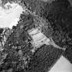
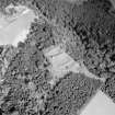
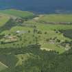
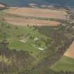
This building (fig. 114), which was dedicated in the name of the B.V. Mary, stands on a grassy plateau adjoining the mansion of Dunglass, rather less than a mile west-north-west of Cockburnspath village. The fabric is still entire, notwithstanding the usage the building received in the 18th century, at which time it was degraded to the purposes of a stable and agricultural store. It is now in the custody of H.M. Office of Works.
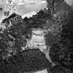
The church is cruciform and rectangular on plan (fig. 115), with a square tower surmounting the crossing, while on the north there is a sacristy opening into the choir by an archway. The nave is wider than the choir, and the western piers of the crossing are attached to the lateral walls in a curiously unstructural fashion. During the operations conducted by H.M. Office of Works, it was found that the north wall of the nave ran across the space now occupied by the transept and terminated at the division between nave and choir. In other words, the building, as originally designed, was two chambered comprising nave and choir, but, before the building was very far advanced, it was decided to add transepts and a central tower. The detail throughout the building is of the same period - the 15th century - and the addition must have been made before the vaulted roofs of the nave and choir were laid.
[for a full architectural description and historical note, see RCAHMS 1924, pp.75-9, figs. 112-7]
RCAHMS 1924, visited 19 August 1915.
Publication Account (1985)
Collegiate status was confirmed by James II to Sir Alexander Hume in 1450. The church may have been founded, however, in 1443, based on an earlier, probably private chapel of1403. Dedicated to the Virgin Mary, it had three chaplains (one of whom was also provost) and four choir boys or servers. By the 18th century it was used as a stable and barn.
Originally conceived without transepts and tower, the church was replanned as a cruciform structure before the vaulted roofs were laid. The stocky, square tower stands within, rather than above the crossing, presumably to give as wide transepts as possible. The choir, to which a priest's door enters from the south transept, retains an attractive triple sedilia (priest's seat) with corbels depicting winged and long-haired angels playing a harp and a lute. There are consecration crosses in the choir and sacristy, tomb recesses in the sacristy and transepts, and several 17th century tombstones in the north transept The tower, accessible it would seem only by a ladder to a doorway high above the west arch, had three storeys and a garret in the spire-the corbels once supporting the floor beams. Three tiers of holes in the vaults of the nave and choir, however, rather than supporting beams for scaffolding during construction are more likely to be later additions to support floors inserted when the church was secularised.
Dunglass was a key point on the north-south coastal route, strategically placed just north of the difficult Pease Burn gorge. Four bridges in all crossed the Dunglass Dean-two post-road bridges of1797 and 1798 (the first collapsed), a spectacular railway viaduct of c1840 and the A1 road bridge of 1931.
Information from 'Exploring Scotland's Heritage: Lothian and Borders', (1985).
Standing Building Recording (November 2011 - December 2011)
NT 76659 71896 This small collection was assessed November – December 2011. It includes a number of stones that can be related to various in situ windows. For example, the choir windows and the W window, which have a similar moulding profile. Some fragments of tomb stones remain, as well as one large broken tomb slab. The upper part of the slab has part of an inscription still remaining. This reads:
'HEAR LYES
ROBERT SIMPSONE
WHO [D]EIED THE 3
OF SE[P]T 166? AND ……
AG[E] ............ '
The lower part of the slab is badly eroded, but still has an hourglass, crossed bones and a skull worked in low-relief on its lower section.
This and other inventories of carved stones at Historic Scotland’s properties in care are held by Historic Scotland’s Collections Unit. For further information please contact hs.collections@scotland.gsi.gov.uk
Prestonkirk
Mary Márkus, Archetype
2012
Watching Brief (4 November 2013)
Under the terms of its PIC contract with Historic Scotland, Kirkdale Archaeology was asked to undertake an archaeological watching brief at Dunglass Collegiate Church in order to monitor the relocation of five kneeler stones within the Crossing, Chancel and Sacristy. The stones were removed by Historic Scotland staff under archaeological supervision and the resulting holes were cleaned and recorded archaeologically. Two of the proposed new sites were also cleared and recorded. This resulted in a total of seven trenches.
The overall findings of this programme of work confirmed the sensitivity of the floor surfaces within much of the church. It is clear that the present chippings immediately overlie a sequence of historic surfaces, all of which have been breached to some extent by the present arrangement of kneeler stones.
Trenches 2, 3, 4 and 5 all contained evidence of a substantial clay floor, extending across the Chancel, the Sacristy and the North Transept. Trenches 2 and 3 both contained evidence of features associated with the clay floor – a possible grave slab in Trench 3 (006) with a marker stone (007) and a post-setting (004) in Trench 2. In Trench 5, and 4, there was evidence of the clay floor overlying a levelling deposit, which in turn sealed a further occupation layer. In Trench 5 this took the form of a paved surface (016), whereas in Trench 4 there was a loose, dark silt deposit (012). There was a similar sequence to trenches 4 and 5 in trenches 6 and 7, where sandstone debris was found over dark loose soil (018 and 020). In turn, the loose deposits found in Trench 1 (003) may be comparable to the latter two deposits. They appear to be evidence of disturbance and possible inhumations.
At this point it seems likely that the stony deposits located towards the area of the Crossing, represent the extension of the church after the 1440s, with the clay deposits noted in the Chancel and Sacristy reflecting the earlier, simpler plan. Evidence of potential burials is located in Chancel, Crossing and Crossing. At this stage it is unclear as to whether the post setting (004) or the possible grave (006) relate to the simpler church plan or to the more elaborate version.
It is clear that all deposits beneath the present chippings in the Crossing, North Transept, Sacristy and Chancel at least, should be regarded as complex and sensitive.
G Ewart 2013
Sponsor: Historic Scotland
Kirkdale Archaeology
Measured Survey
Drawings by John B Lawson in the National Art Survey of Scotland Collection.
Measured Survey
Drawings by D J Chisholm in the National Art Survey of Scotland Collection.

