
Torness Power Station


Power Station (20th Century)
Site Name Torness Power Station
Classification Power Station (20th Century)
Alternative Name(s) Torness, Nuclear Generating Station
Canmore ID 58840
Site Number NT77NW 52
NGR NT 74570 75130
NGR Description Centred NT 74570 75130
Datum OSGB36 - NGR
Permalink http://canmore.org.uk/site/58840


- Council East Lothian
- Parish Innerwick (East Lothian)
- Former Region Lothian
- Former District East Lothian
- Former County East Lothian
NT77NW 52.00 centred 74570 75130
Power Station (under construction) [NAT]
OS 1:10,000 map (NT77NW), 1983.
Torness Power Station [NAT]
OS 1:10,000 map (NT77SW), 1991.
NT77NW 52.01 NT 74672 75643 to NT 74804 75505 Breakwater
NT77NW 52.02 NT 74727 75484 Slipway ('Landing Stage')
Location formerly entered as NT 746 751.
Extends onto map sheet NT77SW.
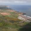
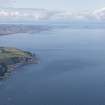
This power station is situated on the East Lothian coast to the N of the A1 public road. A protected slipway to the N allows the receipt of heavy cargoes, while there is a fenced railway siding on the East Coast Main Line (to the S).
Information from RCAHMS (RJCM), 13 February 2006.
Construction (1979 - 1984)
First reactor operational1987.
Project (2007)
This project was undertaken to input site information listed in 'Civil engineering heritage: Scotland - Lowlands and Borders' by R Paxton and J Shipway, 2007.
Publication Account (2007)
This power station, which produces up to 1362MW of electricity from two advanced gas-cooled reactors, was built on a 200 acre site by Sir Robert McAlpine from 1979–84, with the first reactor becoming operational in 1987. McAlpine’s had already developed an expertise in this field in Scotland having built the power stations at
Cockenzie, Longannet, Hunterston ‘B’ and Inverkip. The civil engineering work was considerable, involving use of the order of two million tons of materials, a workforce of up to 3000 and a cost of nearly £240 million. There were 340 accidents, none fatal. Site preparation involved the excavation of 3 270 000 cu yards of material and the installation of over 114 miles of coastal defences with about 500 000 tons of local quarried rock armouring. More intricate work included the pre-stressed concrete pressure vessels of the reactors. Each was helically prestressed by means of about 3000 tons of 0.7 in. compact strand steel wire formed into seven-strand sections. These were incorporated into the 19 ft thick walls and construction was achieved in 20 concrete lifts. Further information is available at the visitor centre. Torness and Hunterston ‘B’ nuclear power stations together are said to generate up to 55% of Scotland’s electricity. An unusual use of the facilities occurred in 2005 when a retired supersonic Concorde aircraft, en route for the Museum of Flight at East Fortune where it is now on display, was unloaded at the jetty.
R Paxton and J Shipway 2007
Reproduced from 'Civil Engineering heritage: Scotland - Lowlands and Borders' with kind permission from Thomas Telford.
Watching Brief (11 January 2016 - 8 December 2016)
An archaeological watching brief was undertaken by Northlight Heritage during the undergrounding of approximately 2 km of electricity cable between Torness Power Station in the north (NT 74485 74827) and an existing substation in the south (NT 74052 72976). The work was conducted variously between 11th January 2016 and 8th December 2016. The topsoil strip corridor averaged around 30 m in width but was up to 50 m in places. No significant archaeological remains were uncovered during the watching brief other than two isolated pits that were heavily disturbed by burrowing.
Information from Dawn Ferry (Northlight Heritage) 31 January 2017
OASIS ID - northlig1-236598
Archaeological Evaluation (11 January 2016 - 8 December 2016)
Northlight Heritage
NT 74485 74827 – NT 74052 72976 A watching brief was undertaken, 11 January 2016 – 8 December 2016, during the placement of c2km of underground electricity cable between Torness Power Station in the N (NT 74485 74827) and a substation in the S (NT 74052 72976). The monitoring of the removal of topsoil from a 30 – 50m wide corridor recorded two isolated pits that were heavily disturbed by burrowing.
Archive: NRHE
Funder: Cnoclee Ltd
Steven Black, Dawn Ferry, Peta Glew, Nicola Reid and David Sneddon – Northlight Heritage

