
Scheduled Maintenance
Please be advised that this website will undergo scheduled maintenance on the following dates: •
Tuesday 3rd December 11:00-15:00
During these times, some services may be temporarily unavailable. We apologise for any inconvenience this may cause.
Duns Law, Covenanters' Stone


Covenanters Stone (17th Century)
Site Name Duns Law, Covenanters' Stone
Classification Covenanters Stone (17th Century)
Canmore ID 58641
Site Number NT75SE 2.01
NGR NT 78469 54723
NGR Description Centre
Datum OSGB36 - NGR
Permalink http://canmore.org.uk/site/58641


- Council Scottish Borders, The
- Parish Duns
- Former Region Borders
- Former District Berwickshire
- Former County Berwickshire
NT75SE 2.1 7847 5472.
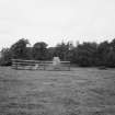
In the NW corner of the redoubt is the Covenanters' Stone which bears a notice: 'On this stone according to unbroken tradition was raised the standard of the Covenanters when in 1639 their army under Sir Alexander Leslie assembled at Duns Law.
RCAHMS 1915.
Field Visit (21 October 1908)
125. Covenanters’ Stone, Duns Law.
At the north-west side of the enclosure on the summit of Duns Law (marked X on plan, fig. 65 [DP 225501]) lies the stone on which the standard of the Covenant is alleged to have been planted in 1639. It is a recumbent block of sandstone, and is enclosed within a railing for preservation.
See Ber. Nat. Club, 1892-93, p. 75.
RCAHMS 1915, visited 21st October 1908.
OS Map: Ber., xvi. NE.
Sbc Note (15 April 2016)
Visibility: Standing structure or monument.
Information from Scottish Borders Council
Note (20 January 2020)
The location, classification and period of this site have been reviewed.

