
Following the launch of trove.scot in February 2025 we are now planning the retiral of some of our webservices. Canmore will be switched off on 24th June 2025. Information about the closure can be found on the HES website: Retiral of HES web services | Historic Environment Scotland
Nisbet House


Tower House (Medieval)
Site Name Nisbet House
Classification Tower House (Medieval)
Alternative Name(s) Nisbet Estate; West Nisbet
Canmore ID 58630
Site Number NT75SE 10
NGR NT 79501 51232
Datum OSGB36 - NGR
Permalink http://canmore.org.uk/site/58630


First 100 images shown. See the Collections panel (below) for a link to all digital images.
- Council Scottish Borders, The
- Parish Edrom
- Former Region Borders
- Former District Berwickshire
- Former County Berwickshire
NT75SE 10.00 79501 51232
NT75SE 10.01 79530 51245 Stable and Coach House, SW Range
NT75SE 10.02 79398 50916 Bridge over Canal
NT75SE 10.03 79528 51257 Stable and Coach House, NW Range
NT75SE 10.04 79565 51263 Stable and Coach House, East Range
NT75SE 10.05 79695 51226 Walled Garden
NT75SE 10.06 79452 51245 Vault
NT75SE 54 79653 50617 Nisbet Dovecot
NT75SE 74 79742 51324 Nisbet Cottage
(NT 79501 51232) Nisbet House (NR)
OS 6" map, (1957).
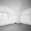
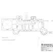
Nisbet House was built in the reign of Charles I (A Nisbet 1816) and it is said that the old castle, defended by a moat, was taken down to make room for it. The older part of the house is oblong, measuring some 63ft by 21ft within walls averaging 3ft 6ins in thickness (see RCAHMS plan, fig.81). The addition, dated 1774, consists of a rectangular west wing in the form of a tower measuring some 38ft by 30ft overall.
RCAHMS 1915, visited 1913; D MacGibbon and T Ross 1892.
Nisbet House (name confirmed by the Caretaker, Nisbet House) is in poor condition although renovations are being carried out. There is no trace of the old castle although the ha-ha between the drive and the lawn may be the remaining evidence of the moat. The family of Carre succeeded the Nisbets (Information from the Caretaker, Nisbet House) and in the burial vault to the NW (at NT 7945 5123) there is a grave slab dated 1667 to John Carre of West Nisbet.
Visited by OS (CJP) 25 June 1956.
Nisbet House is as described and appears to be in good condition. There is no trace of the moat.
Visited by OS (JP) 11 December 1970.
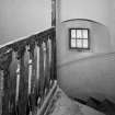
Although not built until about 1630, this large mansion has the most spectacular array of splayed shot-holes in the Borders: they are liberally distributed at every level from the basement to the wall-head.
A M T Maxwell-Irving 1974.
RCAHMS 1980, visited 1979.
NMRS REFERENCE:
Owner: Lord Brocket
17c., with early 10c. additions. 19c additions removed, 1956.
Inventory of Kimmerghame Drawings - typescript (R6(P27))
Ferguson Sketch book No. 10 - 18 pages of pencil drawings. Held in Printroom.
EXTERNAL REFERENCES:
National Library.
Plan for the improvement of Nisbet the seat
of Miss Carr. T. White 1784. MS5460(1) - plan showing planting scheme.
Scottish Record Office.
View of [Nisbet House] [North Front].
Sketch signed by H D Scott shows the old and new part of the house.
1808 GD 157/1992
Field Visit (27 April 1913)
150. Nisbet House.
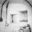
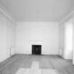
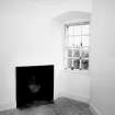
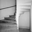
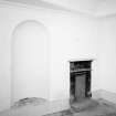
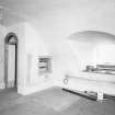
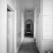
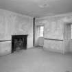
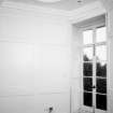
This mansion-house is situated about 2 miles to the south of Duns on the east side of the road to Coldstream. The older part of the building is oblong on plan (fig. 81), measuring some 63 feet by 21 feet within walls averaging 3 feet 6 inches in thickness. At each of the south angles there is a circular tower (fig. 79[SC 1173155]) with an outward projection of fully 10 feet, while the north elevation (fig. 80 [SC 1173154]) is varied in treatment by two square wings containing wheel-stairs which give direct access from the basement to the level of the third floor, whence the attic is gained by two turret stairs corbelled out over the eastern re-entering angles. The original entrance doorway, now built up, is still to be seen on the exterior of the main north wall. It is of the plain square-headed type with a broad double bead-and-hollow moulding wrought on the jambs and lintel. The whole is enclosed by a curved and moulded label over which is a re-cut panel within a. moulded margin bearing the arms of the Kerrs, thus: On a chevron three stars, a crescent in dexter chief; Crest, on a helmet with mantling, a stag head; initials at top of shield I.K. And at foot the same; Motto, beneath the last, FORWARD. The existing entrance has apparently been formed in the south-west tower (fig. 79) when the west addition was built at the end of the 18th century. This later addition consists of a rectangular west wing carried up in the form of a tower measuring some 38 feet by 30 over all, having a vaulted basement and three upper floors terminating in a projecting crenellated parapet, supported by moulded corbels. Incised on the keystone of the upper west window is the date 1774 flanked by the initials A and L. The ceiling of the apartment on the level of the first floor is decorated with ornate plaster-work of the Adams period. Within the main portion of the building the arrangement is characteristic of the 17th century. The rooms have originally been the fullwidth of the house entering one off the other. The partitions shown by hatched lines on the plan are all of modern construction. The ground floor contains the kitchen at the east end communicating by the old entrance passage with a southern row of cellars. On the first floor is the great hall measuring some 40 feet in length, while a doorway formed in the east wall communicates directly with a large private room and with the landing of the east stair-case. At this level both angle towers have formed small private rooms which entered directly from the hall and from the room adjoining. The east and west stairs have evidently served respectively as a public and private means of access to the third floor. The numerous shot-holes which occur in the tower and staircase walls are remarkable, showing the retention of a defensive feature in It house which is of an advanced type in other respects. According to Nisbet's Heraldry this mansion was built by Sir Alexander Nisbet of that ilk during the reign of Charles I [1625-1649]. It is said that he took down the old castle, which was defended by a moat, in order to make room for the existing mansion. In this case the shield bearing the arms of the Kerrs may be assumed to represent a fragment of the old castle.
RCAHMS 1915, visited 27th April 1913.
OS Map: Ber., xvi. SE.
Photographic Survey (1956)
Five photographs of Nisbet House, Berwickshire, by the Scottish National Buildings Record in 1956.
Sbc Note (21 March 2016)
Visibility: This was the site of an archaeological monument, which may no longer be visible.
Information from Scottish Borders Council
Previously also listed under duplicate site NT96SW 510 -CANCELLED. HES (LCK) 11.6.2024

