
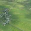
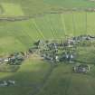
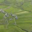
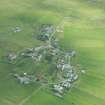
Ireland, Church And Burial-ground


Burial Ground (Medieval), Church (Medieval)
Site Name Ireland, Church And Burial-ground
Classification Burial Ground (Medieval), Church (Medieval)
Canmore ID 586
Site Number HU32SE 3
NGR HU 37610 21928
Datum OSGB36 - NGR
Permalink http://canmore.org.uk/site/586


- Council Shetland Islands
- Parish Dunrossness
- Former Region Shetland Islands Area
- Former District Shetland
- Former County Shetland
HU32SE 3 3760 2192.
(HU 3760 2193) Church and Burial Ground (LB)
OS 6" map, Shetland, 2nd ed. (1903)
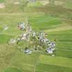
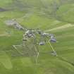
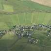
This church and burial ground have been demolished, but it is believed, on rather slender grounds, to have belonged to the same 12th century group of round-towered churches as Egilsay (HY43SE 1). The 'Walls and Steeple of an Old Kirk' still stood in 1711. (R Sibbald 1711)
RCAHMS 1946, visited 1930
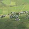
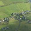
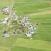
Site now occupied by a house built in 1947. A worked stone with a beaded corner from the side of a doorway, recovered when clearing the site, is in Lerwick Museum.
Visited by OS (RL) 8 May 1968.
Field Visit (16 July 1930)
Church and Burial-ground, Ireland. This church and burial-ground have been entirely demolished, but the site is believed to have been immediately behind some old cottages at the NW corner of the township. Sibbald says in his Description of the Isles of Shetland (1711) (1): ‘Southward from Maweek lyes an Hill called Ireland Head, from which towards South-East lyes a Village called Ireland, where stand the Walls and Steeple of an Old Kirk’. This is believed to have been a round-towered church (2).
RCAHMS 1946, visited 16 July 1930.
OS 6" map, Shetland, 2nd ed. (1903)
(1) P. 15. Sibbald's authority was the Rev. James Kay. See the privately printed collection of documents entitled Description of ye Countrey of Zetland, p. 30, of which there is a copy in the Library of the Society of Antiquaries of Scotland.
(2) Goudie, Celtic and Scandinavian Antiquities of Shetland, p. 50. See also Vol. i, Introduction, p. 44, footnote.

