
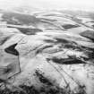
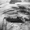
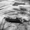
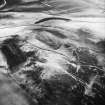
Cockburn Law


Field System (Prehistoric)
Site Name Cockburn Law
Classification Field System (Prehistoric)
Canmore ID 58597
Site Number NT75NE 35
NGR NT 76936 59527
NGR Description Centre
Datum OSGB36 - NGR
Permalink http://canmore.org.uk/site/58597


- Council Scottish Borders, The
- Parish Duns
- Former Region Borders
- Former District Berwickshire
- Former County Berwickshire
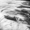
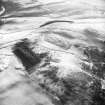
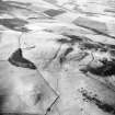
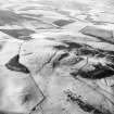
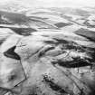
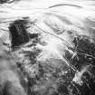
NT75NE 35 768 594 to 769 596
See also NT75NE 3.
NT 768 594 to NT 769 596. The remains of a prehistoric field system survive in a narrow strip of ground immediately NW of the improved land on the SE flank of Cockburn Law. The upper limit of the field system is defined by a stony bank which follows the 244m contour over a distance of about 120m; three field divisions run away from it and there are traces of others overlain by the rig-and-furrow cultivation around the settlement described on NT75NE 3.
RCAHMS 1980, visited 1980.
Note (6 January 2020)
The location, classification and period of this site have been reviewed.
Sbc Note
Visibility: This is an upstanding earthwork or monument.
Information from Scottish Borders Council

