Pricing Change
New pricing for orders of material from this site will come into place shortly. Charges for supply of digital images, digitisation on demand, prints and licensing will be altered.
Upcoming Maintenance
Please be advised that this website will undergo scheduled maintenance on the following dates:
Thursday, 9 January: 11:00 AM - 3:00 PM
Thursday, 23 January: 11:00 AM - 3:00 PM
Thursday, 30 January: 11:00 AM - 3:00 PM
During these times, some functionality such as image purchasing may be temporarily unavailable. We apologise for any inconvenience this may cause.
Belchester
Earthwork (Prehistoric), Rig And Furrow (Medieval) - (Post Medieval)
Site Name Belchester
Classification Earthwork (Prehistoric), Rig And Furrow (Medieval) - (Post Medieval)
Canmore ID 58523
Site Number NT74SE 12
NGR NT 7925 4350
Datum OSGB36 - NGR
Permalink http://canmore.org.uk/site/58523
- Council Scottish Borders, The
- Parish Eccles
- Former Region Borders
- Former District Berwickshire
- Former County Berwickshire
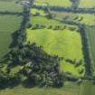
This earthwork fortification, which is thought to be of medieval date, comprises two banks and a medial ditch which enclose an oval area. A large portion of the defences has been damaged by later rig-and-furrow cultivation.
The surviving part of the earthwork is situated just below the crest of a ridge. The ditch measures around 14m across, while the oval-shaped area it encloses measures approximately 150m x 60m.
It is not clear what would have been inside the fortification; although it is situated on the highest piece of ground in the area, it is not a particularly defensive or dominant position. Nearby Belchester House is also thought to have its origins in the medieval period, so may be associated in some way.
Text prepared by RCAHMS as part of the Accessing Scotland's Past project
NT74SE 12 7925 4350.
(NT 7925 4350) Earthwork (NR)
OS 1:10,000 map, 1972.
Remains of a large oval fort, consisting of a deep trench measuring about 44ft across. It formerly had two earthen ramparts, which have been entirely obliterated, as has the ditch on the N and NW.
RCAHMS 1915.
Situated on a plateau with the ground falling sharply for about 30m to the NW. The average dimensions of the remaining trench are 14m wide and 2.2m deep on outer scarp, 1.3m deep on inner scarp. At the W extremity the counterscarp to the outer face of the ditch is 0.4m high; at the E extremity the ditch is traceable for a short distance in the wood, but it is mutilated by a boundary bank crossing it. The whole area is covered by rig-and- furrow, and no trace of the N portion of the defences was seen, though there was heavy snow at the time of visit. As the ground falls so sharply to the N, it is not considered likely that the obliterated ramparts and ditch would have run up and down the slope; it is probable that they followed the N edge of the level ground; this would tend to be confirmed by markings on air photographs (Visible on RAF air photographs: 106G Scot/UK16: 5216-7). Although sited on the highest point in the immediate vicinity, the countryside is generally flat and the earthwork cannot be said to occupy a dominating position.
Visited by OS(JFC) 18 January 1955.
Generally as described in the previous field report and planned by the RCAHMS.
Resurveyed at 1:2500.
Visited by OS(RD) 14 July 1966.
This oval earthwork, which may be of medieval date, is situated just below the crest of a broad ridge. It measures 150m by about 60m within double banks and a medial ditch, although on the NW side these have been removed by rig-and-furrow cultivation.
RCAHMS 1980, visited 1979.
Field Visit (23 October 1908)
141. Fort, Belchester.
About ½ mile south-south-east of the village of Leitholm, and some 150 yards west of Belchester House, at an elevation of about 250 feet above sea-level, are the remains of a large oval fort (fig. 75). Its site is a plateau, whence the ground falls sharply away towards the north-west. The defences remain for about one-half of the periphery, and consist of a deep trench measuring about 44 feet across. The ramparts have been entirely obliterated, as also has the ditch on the north and north-west.
RCAHMS 1915, visited 23rd October 1908.
OS Map: Ber., xxviii. NE.
Note (27 January 2016 - 30 May 2016)
This fort is situated immediately W of the policies of Belchester House, but rather than occupying the very summit of this low rounded hill, its defences take in a slightly lower shelf forming the NW shoulder, and while the ground falls away a little more steeply along the NW flank, it has proved easily accessible to ploughmen. Consequently the whole of the NW flank and the NE end have been levelled by rig-and-furrow cultivation, the rigs curling into the interior from W to E and preserving elements of the SW end and the SE flank under the headlands of the furlongs. Oval on plan, the interior has measured about 170m from NE to SW by possibly as much as 80m transversely (1.1ha), and while the inner rampart has been obscured by features of the ploughing, a ditch some 10m in breadth and a counterscarp rampart spread some 8.5m thick by 0.4m high are clearly visible at the SW end and along the SE flank, where the counterscarp has been subsumed into the headland of an adjacent furlong. An old pond has been dug into the bottom of the ditch on the S, and though James Hewat Craw's plan drawn up about 1912 shows a gap in the perimeter on its NW side, the position of the original entrance is unknown.
Information from An Atlas of Hillforts of Great Britain and Ireland – 30 May 2016. Atlas of Hillforts SC4048
Sbc Note
Visibility: This is an upstanding earthwork or monument.
Information from Scottish Borders Council


