
Following the launch of trove.scot in February 2025 we are now planning the retiral of some of our webservices. Canmore will be switched off on 24th June 2025. Information about the closure can be found on the HES website: Retiral of HES web services | Historic Environment Scotland
Polwarth Church


Burial Ground (Period Unassigned), Church (18th Century), Font (Medieval), War Memorial (20th Century)
Site Name Polwarth Church
Classification Burial Ground (Period Unassigned), Church (18th Century), Font (Medieval), War Memorial (20th Century)
Alternative Name(s) Polwarth Kirk; War Memorial Roll Of Honour
Canmore ID 58498
Site Number NT74NW 19
NGR NT 74995 49492
Datum OSGB36 - NGR
Permalink http://canmore.org.uk/site/58498


- Council Scottish Borders, The
- Parish Polwarth
- Former Region Borders
- Former District Berwickshire
- Former County Berwickshire
Polwarth Parish Church was built in 1703, on the site of an earlier church. It is surrounded by an oval-shaped burial-ground, which contains gravestones dating from the seventeenth century.
A Latin inscription on the south wall of the church records that a church was first built on this site in the year 900, although the first known reference to a church here is a re-dedication to St Mungo in 1242.
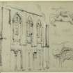
The 1703 building is rectangular on plan with a later square tower to the west and a nineteenth-century north aisle. It is harled, with dressings of smooth red sandstone. It incorporates an earlier burial-vault, used by the Marchmont family.
In 1684, the vault famously served as the hiding-place of Sir Patrick Hume, who had been implicated in the Rye House plot, a conspiracy to assassinate King Charles II of England and his brother James, Duke of York. A crowned finial at the east end of the church is a reference to William of Orange, who restored the Hume's fortunes in 1688.
Text prepared by RCAHMS as part of the Accessing Scotland's Past project
NT74NW 19.00 74995 47492
NT74NW 19.01 74802 49577 Manse
NT74NW 19.02 74786 49557 Manse, Walled Garden
NT74NW 19.03 74781 49585 Manse, SW Steading Range
NT74NW 19.04 74781 49599 Manse, NW Steading Range
NT74NW 19.05 74793 49600 Manse, E Steading Range
NT74NW 19.06 74801 49687 Manse, Bridge
NT74NW 19.07 74806 49701 Manse, Gate Piers
(NT 74995 47492) Polwarth parish church, dedicated to St Mungo, was built in 1703 on the site of an earlier structure, of which a burial vault is incorporated under the E end. It is T-shaped on plan with a tower at its W end. There is a latin inscription on the S wall stating that the church was consecrated before 900, and restored in 1378. Just inside the churchyard gate, there is a font, 2ft 9ins high and 2ft 4ins in diameter, which may be of the latter date.
G Hay 1957; RCAHMS 1915, visited 1908; R Gibson 1905.
The latin inscription states that the church was consecrated before 900, rebuilt and dedicated to St Mungo in 1242 and again rebuilt in 1378. The Norman font is now in the church, which is still in use.
Visited by OS(RD) 22 July 1970.
There was a church here by the middle of the 13th century, but there is little apparent evidence to support the claim that there was a church here before 900.
RCAHMS 1980, visited 1979.
NMRS REFERENCE:
EXTERNAL REFERENCE:
Scottish Record Office -
Polwarth. Inscription for the rebuilt Church.
The church was consecrated before 900, restored in 1378 and rebuilt in 1703
by Patrick, 1st Earl of Marchmont.
Copy
[1703] N.D. GD 158/464
Field Visit (15 August 1908)
275. Polwarth Church.
Situated about ½ mile south-south-east of the village of Polwarth is a reconstructed edifice dating from 1703, on the site of an ancient building. It measures 55 feet by 24 feet externally, and has a tower at the west end. The vault beneath the east end probably belongs to an earlier structure; it is believed to have formed the hiding-place in 1684 of Sir Patrick Hume of Polwarth, afterwards first Earl of Marchmont, who had been declared a participant in the Ryehouse Plot (1). There is a long Latin inscription on the south wall, giving the history of the church and the date of the reconstruction.
Font.
A plain but complete example of a baptismal font stands within the churchyard, near the gate. The bowl is circular, and externally it tapers slightly towards the base. There is no stem proper, the bowl standing on a circular slab, which rests on another and larger slab forming the base. The total height from the ground is 2 feet 9 inches; the external diameter of the bowl is 2 feet 4 inches; the diameter of the orifice 1 foot 10 inches, and the depth 2 inches. The font dates probably from the 13th century.
See Ber. Nat. Club, 1890-91, p. 163; Humes of Polwarth, p. 7; Antiquaries, xxi. p. 361; 1 Scots Peerage, vi. p. 13.
RCAHMS 1915, visited 15th August 1908.
OS Map: Ber., xxii. NW.
Photographic Survey (May 1962)
Photographic survey of the exterior of Polwarth Church, Berwickshire, by the Scottish National Buildings Record in 1962
Test Pit Survey (6 March 2023 - 29 March 2023)
NT 74998 49490 (centred) AOC Archaeology Group was commissioned by Page/Park Architects on behalf of their client The Marchmont Makers Foundation regarding a proposed set of investigation works, which comprised ten trial pits (Phase 1) and ten interior site investigative holes. These were designed to confirm the substructure make up,
ground conditions and bearing capacity at Polwarth Kirk, Berwickshire, The Scottish Borders. Two additional trial pits were excavated in relation to locating an electric cable trench and understanding the depth of made ground in the previously disturbed footprint of the tarmac path.
The works were centred around the Polwarth Kirkyard established in 1703 CE and in the neighbouring woodland to the southwest. The Phase 1 archaeological watching brief allowed for the assessment of foundations and ground conditions over the Kirkyard area, wooded area to the southwest, and interior of the church.
The results of the Phase 1 watching brief suggest a significant amount of made ground across the western side of the Kirk Yard relating to the installation of a tarmac path in pits 6, 7 and 12. In Pit 7 made ground was laid directly over topsoil containing post medieval detritus and a single fragment of disarticulated human bone. The limited investigation of this western area suggests it is free from
burials, and this includes the wooded area to the southwest where sterile natural subsoil was encountered (Pits 8-10). However, given only small trial pits were excavated within the kirkyard area the presence of in situ remains elsewhere should not be discounted.
A sandstone foundation was present in Test Pit 6 and may relate to the
foundations of an earlier church structure, predating the early 18th century construction. A crude drystone foundation was observed in Test Pit 5, and the remains of a metal fence footing was observed in Trial Pit 3 and likely relates to the presence of a private fenced burial ground located in that area. Small fragments of disarticulated human bone were observed in the soils of Trial Pits 2 and 3 and are likely the remains of previous disturbance through successive grave cutting and movement of soils. The disarticulated remains were reinstated where found.
Interior works confirmed the structural improvements made in 1928. No
additional burials were identified between the current floor and the underlying crypt below.
Given the highly sensitive nature of the site it is recommended that any further ground breaking works inside the Kirkyard will require a watching brief at all times. This is however a decision to be made by Scottish Borders Council Archaeological Services (SBCAS).
Information from AOC Archaeology Group.
Sbc Note
Visibility: This is an upstanding building.
Information from Scottish Borders Council.

