
Wallace's Tower


Tower House (16th Century)
Site Name Wallace's Tower
Classification Tower House (16th Century)
Alternative Name(s) Roxburgh Tower
Canmore ID 58434
Site Number NT73SW 31
NGR NT 70016 30477
Datum OSGB36 - NGR
Permalink http://canmore.org.uk/site/58434


- Council Scottish Borders, The
- Parish Roxburgh
- Former Region Borders
- Former District Roxburgh
- Former County Roxburghshire
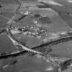
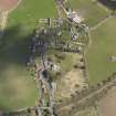
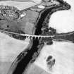
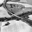
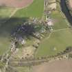
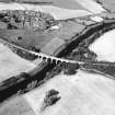
The ruins of Wallace's Tower, a sixteenth-century tower-house, stand in an arable field on the west bank of the River Tweed, about 200m north-west of the disused Roxburgh viaduct. What remains of the building stands no higher than the first floor, and the ruins are heavily overgrown.
The tower-house is rectangular on plan, with two wings projecting from its northern end. One wing, now almost wholly ruined, appears to have housed a stairwell and what may have been the main entrance, with a doorway visible at the foot of the stair into the main block. The ground floor of the main block appears to have been a vaulted chamber, perhaps a kitchen, while the ground floor of the other wing also contains a vaulted chamber which may have been a cellar or store room.
Wallace's Tower is named in a charter of 1543, which confirmed Walter Ker of Cessford (an ancestor of the present Duke of Roxburghe) as owner of the lands of the East Mains of Roxburgh. It may have been part of a chain of signal towers designed to warn of English attacks or other dangers.
Text prepared by RCAHMS as part of the Accessing Scotland's Past project
NT73SW 31 70016 30477
(NT 7001 3047) Wallace's Tower (NR) (Remains of).
OS 6" map, Roxburghshire, (1924).
Wallace's Tower, Roxburgh. This 16th-century structure, which stands in a cultivated field on the left bank of the Tweed immediately E of Roxburgh Junction, has been reduced to its lowest floor and is so overgrown that a full analysis is impossible until the vegetation is removed. It includes an oblong main block lying SW and NE from the SW part of which project two wings, the W one being in alinement with the SW gable and the other one attached to the S corner and therefore salient both to the SW gable and to the SE wall. The W wing, although a mere fragment, is still sufficiently complete to include a segment of circular walling, evidently the back of a stair-well, into which the tower entrance probably opened from the NE and gave access to the main block through a doorway at the foot of the stair. On the lowest floor of the larger unit there is a vaulted cellar measuring 28ft 6in by 16ft 6in, lit from both side-walls and the SW gable and having two aumbries in the NW wall. This division communicated with the upper floor of the N wing by means of a service-stair. It also has a door into the lowest storey of the S wing, a small vaulted chamber measuring 11ft 10in by 11ft 2in lit from NE and SW and having an aumbry in the SW gable. The masonry is of freestone rubble. All of the windows are small and have rounded arrises.
In 1543 Walter Ker of Cessford and Isobel Ker his wife received a charter of confirmation of the lands of the East Mains of Roxburgh 'cum turre et fortalicio earundem' (Reg Magni Sig Reg Scot 1513-46, 1882-1914).
RCAHMS 1956, visited 8 July 1933.
As described above except for the incorrect orientation which has now been amended in the text.
Visited by OS (RDL) 29 November 1963.
Sbc Note
Visibility: Upstanding building, which may not be intact.
Information from Scottish Borders Council

