|
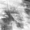
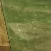
Photographs and Off-line Digital Images |
RX 1413 |
RCAHMS Aerial Photography |
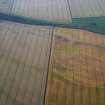
Oblique aerial view. |
1976 |
Item Level |
|
|
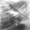
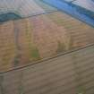
Photographs and Off-line Digital Images |
RX 1414 |
RCAHMS Aerial Photography |
Oblique aerial view. |
1976 |
Item Level |
|
|
Photographs and Off-line Digital Images |
RX 3948 CN |
John Dewar |
Oblique aerial view. |
1976 |
Item Level |
|
|
Photographs and Off-line Digital Images |
RX 3949 CN |
John Dewar |
Oblique aerial view. |
1976 |
Item Level |
|
|
Photographs and Off-line Digital Images |
RX 3950 CN |
John Dewar |
Oblique aerial view. |
1976 |
Item Level |
|
|
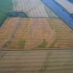
Photographs and Off-line Digital Images |
C 46554 |
RCAHMS Aerial Photography |
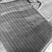
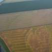
Redden Haugh, oblique aerial view, taken from the N, centred on the cropmarks of pits. A further area of indeterminate cropmarks is visible in the centre left of the photograph. |
28/6/1995 |
Item Level |
|
|
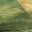
Photographs and Off-line Digital Images |
C 46555 |
RCAHMS Aerial Photography |
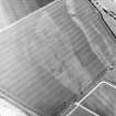
Redden Haugh, oblique aerial view, taken from the NNW, centred on the cropmarks of pits. Cropmarks of enclosures and ring-ditches are visible in the top left-hand corner of the photograph. |
28/6/1995 |
Item Level |
|
|
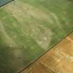
Photographs and Off-line Digital Images |
C 46556 |
RCAHMS Aerial Photography |
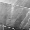
Redden Haugh, oblique aerial view, taken from the W, centred on the cropmarks of pits. Cropmarks of enclosures and ring-ditches are visible in the top half of the photograph. |
28/6/1995 |
Item Level |
|
|
Photographs and Off-line Digital Images |
C 46557 |
RCAHMS Aerial Photography |
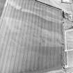
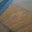
Redden Haugh, oblique aerial view, taken from the WSW, centred on the cropmarks of pits, enclosures and ring-ditches. |
28/6/1995 |
Item Level |
|
 |
On-line Digital Images |
SC 1749630 |
RCAHMS Aerial Photography |
Redden Haugh, oblique aerial view, taken from the N, centred on the cropmarks of pits. A further area of indeterminate cropmarks is visible in the centre left of the photograph. |
28/6/1995 |
Item Level |
|
 |
On-line Digital Images |
SC 1749631 |
RCAHMS Aerial Photography |
Redden Haugh, oblique aerial view, taken from the NNW, centred on the cropmarks of pits. Cropmarks of enclosures and ring-ditches are visible in the top left-hand corner of the photograph. |
28/6/1995 |
Item Level |
|
 |
On-line Digital Images |
SC 1749632 |
RCAHMS Aerial Photography |
Redden Haugh, oblique aerial view, taken from the W, centred on the cropmarks of pits. Cropmarks of enclosures and ring-ditches are visible in the top half of the photograph. |
28/6/1995 |
Item Level |
|
 |
On-line Digital Images |
SC 1749633 |
RCAHMS Aerial Photography |
Redden Haugh, oblique aerial view, taken from the WSW, centred on the cropmarks of pits, enclosures and ring-ditches. |
28/6/1995 |
Item Level |
|
 |
On-line Digital Images |
SC 1749740 |
RCAHMS Aerial Photography |
Oblique aerial view. |
1976 |
Item Level |
|
 |
On-line Digital Images |
SC 1749741 |
RCAHMS Aerial Photography |
Oblique aerial view. |
1976 |
Item Level |
|
 |
On-line Digital Images |
SC 1788712 |
John Dewar |
Oblique aerial view. |
1976 |
Item Level |
|
 |
On-line Digital Images |
SC 1788713 |
John Dewar |
Oblique aerial view. |
1976 |
Item Level |
|
 |
On-line Digital Images |
SC 1788714 |
John Dewar |
Oblique aerial view. |
1976 |
Item Level |
|
 |
On-line Digital Images |
SC 2454724 |
Records of the Ordnance Survey, Southampton, Hampshire, England |
Redden, NT73NE 40, Ordnance Survey index card, Recto |
c. 1958 |
Item Level |
|
 |
On-line Digital Images |
DP 404646 |
Historic Environment Scotland |
Oblique aerial view |
19/7/2023 |
Item Level |
|
 |
On-line Digital Images |
DP 404647 |
Historic Environment Scotland |
Oblique aerial view |
19/7/2023 |
Item Level |
|
 |
On-line Digital Images |
DP 404648 |
Historic Environment Scotland |
Oblique aerial view |
19/7/2023 |
Item Level |
|
 |
On-line Digital Images |
DP 404649 |
Historic Environment Scotland |
Oblique aerial view |
19/7/2023 |
Item Level |
|
 |
On-line Digital Images |
DP 404650 |
Historic Environment Scotland |
Oblique aerial view |
19/7/2023 |
Item Level |
|


