
Following the launch of trove.scot in February 2025 we are now planning the retiral of some of our webservices. Canmore will be switched off on 24th June 2025. Information about the closure can be found on the HES website: Retiral of HES web services | Historic Environment Scotland
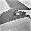
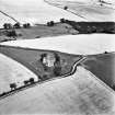
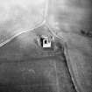
Cessford Castle


Castle (Medieval)
Site Name Cessford Castle
Classification Castle (Medieval)
Canmore ID 58306
Site Number NT72SW 2
NGR NT 73808 23840
Datum OSGB36 - NGR
Permalink http://canmore.org.uk/site/58306


- Council Scottish Borders, The
- Parish Eckford
- Former Region Borders
- Former District Roxburgh
- Former County Roxburghshire
NT72SW 2 73808 23840
For (successor) country house of Cessford (NT 7377 2344), see NT72SW 18.00.
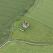
(NT 7380 2384) Cessford Castle (NR) (In Ruins).
(NT 7380 2387) Sword and Dagger found AD 1858 (NAT).
OS 25" map, (1920).
Cessford Castle.
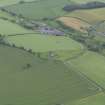
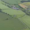
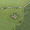
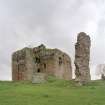
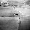
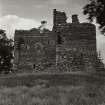
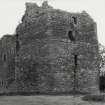
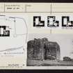
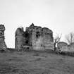
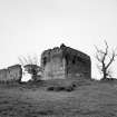
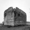
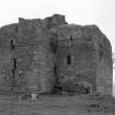
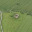
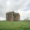
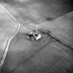
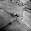
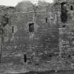
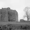
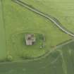
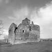
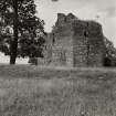
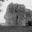
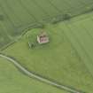
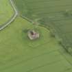
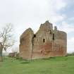
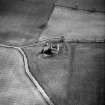
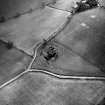
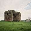
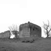
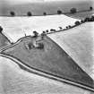
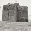
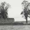
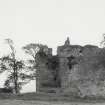
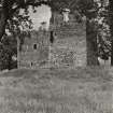
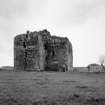
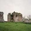
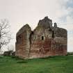
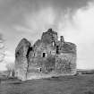
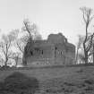
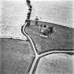
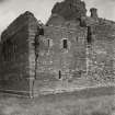
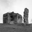
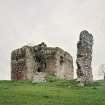
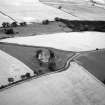
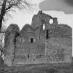
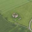
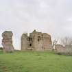
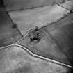
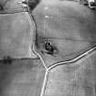
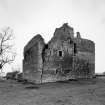
The ruin of this castle, which in 1523 the English esteemed the third strongest place in Scotland, (Letters and papers, Henry VIII), stands on high ground overlooking the valley of Kale Water about 6 miles NE. of Jedburgh (See RCAHMS 1956, Pl.24, fig.110). It has been a massive L-shaped tower, disposed with its re-entrant angle open to the NE and its main block, which is on the W, running N and S. On its N and W sides there are fragments of outbuildings; and foundations of others, including those of a small round tower, seem to lie buried on the E side. The whole site is enclosed by the remains of an earthwork represented at present only by a rampart of earth and stone, nowhere more than 5ft in height, outside of which ran a ditch barely traceable today.
In the year 1519 Cessford, with other Scottish fortresses, was cast down (Letters and papers, Henry VIII) by the English, but the damage then done obviously cannot have been considerable. In May 1523 the Earl of Surrey, with Lord Dacre and others, attacked the castle, in the absence of its owner, with a battery of eleven cannon. The commander's report (letters and papers, Henry VIII), not only gives some interesting details of the operations but also some particulars of the structure. The fortress was "vaw- mewred (fore-walled) with earth of the best sort that I have seen", and had a barbican with a false barbican within it to defend the gate of the "dongeon." The English battery opened on the "vawmewre", but did little damage. Meanwhile, the barbican, (The barbican lay between two of the N outbuildings, and the false barbican can still be made out), was entered by means of scaling-ladders and, while the English ordnance and archers kept up a brisk fire against the "vawmewre", scaling-ladders were reared against the dongeon, but without avail. At this juncture two culverins were diverted to another side of the dongeon and fired at a blocked-up window about 6ft from the ground, which was opened and somewhat enlarged. The gunners then shovelled in four barrels of powder, but the Scots observing what was happening set fire to the house "where our men had thrown the powder" before they had finished. Three of the gunners were badly burnt and the powder was wasted without injuring the fortress. Shortly afterwards, the owner, Sir Andrew Ker, Warden of the Marches, returned and handed the place over, being allowed to depart with bag and baggage. The English commander remarks that had the defence been continued he does not see how the castle could have been taken. He records that the wall, presumably that of the tower, was 14ft thick. The English burnt the castle in 1543, and again in the following year.
Outbuildings:
Between the two outbuildings on the NE of the tower ran the barbican, their adjoining gables forming its sides. The W outbuilding, represented mainly by its outer wall, measured about 66ft by 22ft over all and had two storeys, neither of which was vaulted. The E building, of which little more than the lower part of its E end is left, measured about 41ft by 22ft and apparently had a vaulted basement and two, if not more, upper floors. Both buildings seem to date from the 16th century. The buildings on the W are even more fragmentary and may be of later date. The "false barbican" is simply a secondary filling-in of the re-entrant angle of the tower, contrived by extending walls on the lines of the N and E gables.
The Tower:
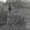
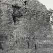
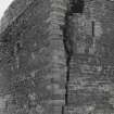
The ruinous condition of the fabric is sufficient evidence of the vicissitudes that the castle suffered in the 16th century, the W and S walls of the main block being deeply rent while those of the wing have had to be extensively repaired. The masonry is red freestone with lighter-coloured dressings; the quoin stones measure as much as 5ft by 2ft by 1ft in height, and all are very finely jointed. The walling is of roughly coursed rubble. Except on the N wall of the wing
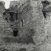
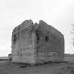
a base-course runs round the building. All the walls of the main block are reduced in thickness at second-floor level by means of an external intake-course, but no such course appears on the wing. Two small corbels on the E side show that the main block was surmounted by a parapet. On the S side of the tower there is an irregular junction between main block and wing starting about 7ft 3in above the base-course, the masonry of the lower part being homogeneous while that above is very poor and uncoursed, and may be a rebuilding. Within the major division there have been three main storeys below the wall-head, while the wing which rises higher had four storeys within a similar height as well as two other storeys above, both of which may have been formed, or merely rebuilt, in the 16th century. When the latter were entire the superstructure of the wing had a most unusual finish. The walls of the lower parts of the wing were very massive, and those of the super- structure comparatively thin; the latter were raised on the inner faces of the former, and the difference in thickness was so great that a sloping roof could be constructed on the N, E, and S sides extending from the wall-head of the superstructure to the outer edges of the thicker walls below. The top of the superstructure was crowned by a bartizan, the parapet of which was borne on chequered corbelling.
The original windows have chamfered jambs, but their lintels are plain, and one of them, which faces S at first-floor level, has a relieving arch. The uppermost window on the E face of the wing, evidently an insertion of later 6th-century date, has a quirked bowtel-and-hollow moulding on its jambs, while the lintel which has fallen to the ground below has two roll-shaped horizontal members forming a cornice.
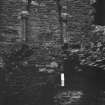
The tower has two entrances, respectively at ground level and on the first floor. The lower entrance lies in the E wall of the main block sheltered within the "false barbican" and covered by two loops in the N wall of the wing. It has a massive chamfered lintel on which, as well as on the wall of the wing adjoining, provision has been made at a later date for an outer door. The original door swings inwards, and opens into a vaulted lobby having on its S side a doorway into the wing and, at its inner end, another door giving access to the lowest floor of the main block.
On its lowest level the wing accommodates a small vaulted lobby giving access first to a dark newel-staircase rising to the top of the building and then to two small vaulted chambers; beside the larger of these there is a vaulted pit, entirely unlighted but provided with a flue for ventilation. The pit was probably entered by a hatchway in the floor of a vaulted chamber, evidently the prison, on the entresol floor, which was in turn entered from the staircase. The lowest storey of the main block on the other hand, is a single compartment, but it had an entresol floor beneath its vault. The vault, however, which has fallen in, may not be an original feature since the side walls seem to have been faced up to support it. Both levels are lit through the gables, while the upper one also has a window to the W exactly opposite its entrance from the newel stair.
The first-floor entrance, which has at some time been built up but is now almost entirely open, is placed in the N. wall of the wing and must have been reached by a wooden ladder rising from the ground to a landing for which provision has been made on the intake-course immediately above the lower entrance. From the first it has been arranged to have two doors, the outer one opening over the landing and the other inwards. The inner door was presumably an iron yett, and was secured by a draw-bar. Within the yett was a vaulted lobby communicating with the staircase, and through this with the first floors both the wing and the main block also. The first floor of the wing was a vaulted kitchen, and still shows traces in the S wall of a large fireplace with an oven at one end and a sink contrived within a pointed-arched opening close by. In the W wall there is a service-hatch opening into the hall; the E wall contains the only window.
The first floor of the main block is devoted to the hall, once a fine room with a vaulted ceiling and adequately lit from all sides but the N. In the centre of the N side there are the remains of a good fireplace with shafted jambs and foliated capitals; this may be as early as the 14th century, but is more likely to be 15th-century work. Three of the windows have seats within their jambs, and from the embrasures of the northernmost on each side are entered two vaulted mural chambers contrived within the N corners of the main block. There is also a third mural chamber at the SW corner of the hall, while the corner opposite contains an additional newel-stair through which access has been obtained to a garderobe whose flue projects externally from the S wall of the wing. The details of the hall shown on the RCAHMS plan, fig. 165, have been reproduced from The Castellated and Domestic Architecture of Scotland, as they were inaccessible at the time of visit.
The superstructure over the hall is both ruinous and inaccessible. The vault, if not an insertion, has been rebuilt, and there is some reason to suppose that whatever lay above was abandoned when it was formed.
The single room on the second floor of the wing was entered from the main staircase; but it also communicated with the hall by means of the S staircase, at the access to which lay a garderobe. It has two windows, one of which has seats on the jambs; a fireplace, which originally had projecting jambs and a hood, both cut off when the fireplace came ultimately to be contracted; and also a sink or basin. The third floor has an early 16th-century fireplace with moulded jambs and has been lighted from N and E, the E window showing signs of a partial reconstruction. The fourth floor has a window and fireplace to the N, and its S wall has a door giving access to the space beneath the sloping roof previously referred to.
The oldest part of the tower has some of the characteristics of 14th-century work, a dating which accords with a story related by James, eleventh Lord Somerville, (Information from Memorie of the Somervills, i, 144) who writing in 1679 tells how John Somerville, baron of Carnwath, was invited over from Linton Tower by his cousin "Sir Robert Kerr of Cessefoord to the castle of Cessefoord then his residence... when at dinner they had the first newes of King Robert the Second his death". This king died on 19 April 1390; Robert Kerr of Auldtounburn is on record about the same time. This story, however, notwithstanding its circumstantial appearance, cannot be accepted as evidence for the date of the structure as in 1390 Cessford belonged to the St Clairs.
Again, a charter to Walter St Clair of the barony of Cessford in 1375-6 (Reg Magni Sig Reg Scot 1306- 1424), makes no mention of a tower on the property, and a sasine of 1441 in favour of Cristian Sinclair, spouse of the deceased Sir William of Cokburne, of her lands whatsoever of Cesfurde, specifically mentions that it is "done in the town of Cesfurde in a building of the same" (W Fraser). This entry suggests that the existing tower had not yet been built. Further, according to the Old Statistical Account of Scotland, Andrew Ker of Atonburn was granted a charter to Cessford in 1446. The second of that name, he was the first to be styled "of Cessford". And in a Letter of Reversion granted by him in 1453 to Sir Robert Colville of Oxnam W Douglas 1925), he speaks of "my manr place of Cesssward". In 1467 a sasine is given at the gates of Cessford Castle, (Information from History Mss Comm. Roxburgh 17). The probability is, therefore, that the tower was built or rebuilt about the middle of the 15th century.
RCAHMS 1956, visited 31 May 1932.
Cessford Castle is generally as described and planned by the Commission.
Resurveyed at 1/2500.
Visited by OS(EGC) 27 May 1968.
Visible on Ordnance Survey large scale vertical air photographs (OS 68/008/077-8).
Information from RCAHMS (RJCM), 27 September 1987.
NT 7380 2384 The dangerous state of the structure (NT72SW 2) has meant that the building has never been examined in detail before, especially the upper floors which had been inaccessible. The present study in July and August 2004 has examined selected areas prior to consolidation work
Two sections of the wall of the barmkin survive on the northern side of the defences that surround the tower. There is documentary evidence from 1523 that this wall was reinforced with earth on its exterior, so as to resist cannon fire - a not unusual technique at that date. The defences would not, therefore, have been as insubstantial as they now appear. In the S (interior) elevation there is a line of joist holes indicating the presence of a two-storey courtyard building. Other voids indicate the presence of a cross-wall associated with this building.
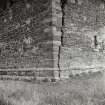
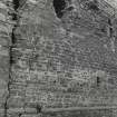
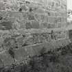
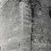
The E exterior wall is constructed of coursed red sandstone, with a lighter stone generally used for the surrounds of openings. The lower part of the wall has a chamfered plinth. Another chamfered course exists buried below the visible one, similar to that on other sides of the building. There is a scarcement which may indicate a change from 15th-century build to the 16th century of the upper two floors.
A first floor chamber appears to be the room of the solar wing of the tower, i.e. the private area of the lord, as opposed to the great hall. It is situated immediately above the kitchen. The S wall of the first floor chamber has a fireplace and an aumbry in its S wall. The aumbry has a shallow basin which drains through the width of the wall. Its front originally projected but has been clawed back. The removal of projecting architectural features on this and the fireplace may indicate the use of panelling, possibly in the 17th century.
Archive to be deposited in the NMRS.
Sponsor: HS.
D Gallagher and D Stewart 2004
Watching brief; standing building recording NT 7380 2384 The second year of masonry consolidation at the massive early 15th-century L-plan tower (NT72SW 2) has been monitored, with occasional site visits between May and September 2005 (DES 2004, 113-14). The repair work and cleaning of the stonework has seen various severe cracks in the fabric of the building and has necessitated scaffolding to its full wall-head height.
The complex history of the castle has been reflected by various stages of rebuild and repair. A full photographic record was undertaken of the exterior elevations and detailed surveys of window, stair and fireplaces at second floor level.
Archive to be deposited in NMRS.
Sponsors: Roxburgh Estates, Waterman Group.
G Ewart 2005
Publication Account (1985)
This massive L-shaped tower overlooks the valley of the Kale Water. It was surrounded by an earth and stone rampart, now no more than 1.5 m high, and formerly bounded by a ditch.
The English attacked Cessford in 1519 and again in 1523 when the Earl of Surrey, with eleven cannon, considered it the third strongest castle in Scotland. It was taken only when its absent owner, Sir Andrew Ker, Warden of the Marches, returned and simply handed it over. In further English invasions in 1543 and 1544 it was burnt; it remains, however, one of the few castles in this area to have escaped entire destruction (Hermitage is another: no. 39).
The tower had two entrances. A ground-level doorway in the east wall of the main block was sheltered by a 'false' barbican enclosing the re-entrant angle of the L, and was covered by two gun-loops in the north wall of the wing (the 'real' defensive barbican ran between the two ruinous outbuildings adjoining the rampart northeast of the tower). Almost directly above, but in the wing, a second entrance must have been reached by a wooden ladder to a projecting landing. It was protected by an iron yett opening inward and a thick wooden outer door opening on to the landing. The lowest parts of the wing contained a vaulted prison with a vaulted and entilated but unlit pit prison below; at first-floor level was the kitchen, adjacent to the main hall with a 15th (possibly 14th) century fireplace and intra-mural chambers once safely reached by a turnpike stair within the wall at the re-entrant angle.
The main tower rose three storeys to the wall-head; the wing, four storeys within the same height (cfNeidpath: no. 38) with a further two storeys above, both of which may have been built (or rebuilt) in the 16th century. The comparatively thin walls of these upper storeys, now fallen, were raised on the inner faces of massive 4.3 m thick lower walls, so that the sloping roof dropped over the upper wall-head to the outer edges of the thicker wall below-a most unusual feature. A further feature are the many huge, finelyjointed corner stones up to 1.5 m by 0.6 m by 0.3 m. A castle, however, to be viewed with care!
Information from 'Exploring Scotland's Heritage: Lothian and Borders', (1985).
Standing Building Recording (22 July 2004)
NT 7380 2384 The dangerous state of the structure (NT72SW2) has meant that the building has never been examined in detail before, especially the upper floors which had been inaccessible. The present study in July and August 2004 has examined selected areas prior to consolidation work. Two sections of the wall of the barmkin survive on the northern side of the defences that surround the tower. There is documentary evidence from 1523 that this wall was reinforced with earth on its exterior, so as to resist cannon fire – a not unusual technique at that date. The defences would not, therefore, have been as insubstantial as they now appear. In the S (interior) elevation there is a line of joist holes indicating the presence of a two-storey courtyard building. Other voids indicate the presence of across-wall associated with this building.
The E exterior wall is constructed of coursed red sandstone,with a lighter stone generally used for the surrounds of openings. The lower part of the wall has a chamfered plinth. Another chamfered course exists buried below the visible one, similar to that on other sides of the building. There is a scarcement which may indicate a change from 15th-century build to the 16th century of the upper two floors.A first floor chamber appears to be the room of the solar wing of the tower, i.e. the private area of the lord, as opposed to the great hall. It is situated immediately above the kitchen. The S wall of the first floor chamber has a fireplace and an aumbry in its S wall. The aumbry has a shallow basin which drains through the width of the wall. Its front originally projected but has been clawed back. The removal of projecting architectural features on this and the fireplace may indicate the use of panelling, possibly in the17th century.
G Ewart and D Gallagher 2004
Sponsor: Historic Scotland
Kirkdale Archaeology
Standing Building Recording (9 May 2005 - 13 October 2005)
NT 7380 2384 The second year of masonry consolidation at the massive early 15th-century L-plan tower (NT72SW 2) has been monitored, with occasional site visits between May and September 2005 (DES 2004, 113–14). The repair work and cleaning of the stonework has seen various severe cracks in the fabric of the building and has necessitated scaffolding to its full wall-head height.
The complex history of the castle has been reflected by various stages of rebuild and repair. A full photographic record was undertaken of the exterior elevations and detailed surveys of window, stair and fireplaces at second floor level.
G Ewart 2005
Sponsor: Historic Scotland
Kirkdale Archaeology
Note (2 November 2015)
This monument was delisted and was removed from the list of buildings of special architectural or historic interest.
The structure is still designated as a scheduled monument under the Ancient Monuments and Archaeological Areas Act 1979.
Information from Historic Environment Scotland, 2 November 2015
Sbc Note
Visibility: Upstanding building, which may not be intact.
Information from Scottish Borders Council

