
Braemoor Knowe


Cultivation Terrace(S) (Period Unassigned), Rig And Furrow (Medieval) - (Post Medieval)
Site Name Braemoor Knowe
Classification Cultivation Terrace(S) (Period Unassigned), Rig And Furrow (Medieval) - (Post Medieval)
Alternative Name(s) Hownam Burn; Kale Water
Canmore ID 58278
Site Number NT72SE 17
NGR NT 7833 2083
Datum OSGB36 - NGR
Permalink http://canmore.org.uk/site/58278


- Council Scottish Borders, The
- Parish Hownam
- Former Region Borders
- Former District Roxburgh
- Former County Roxburghshire
NT72SE 17 7833 2083.
(Centred: NT 7833 2083) Cultivation Terraces. (NAT).
OS 6" map, Roxburghshire, (1923).
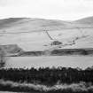
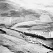
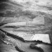
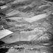
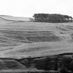
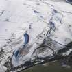
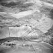
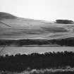
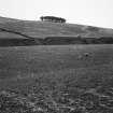
Cultivation Terraces, Braemoor Knowe.
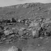
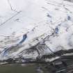
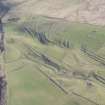
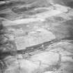
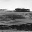
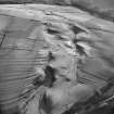
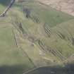
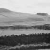
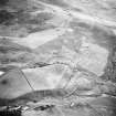
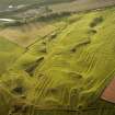
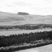
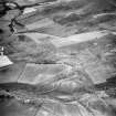
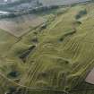
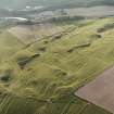
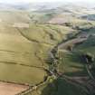
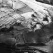
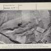
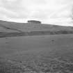
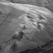
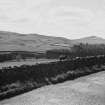
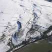
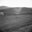
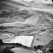
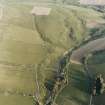
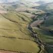
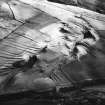
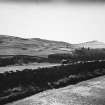
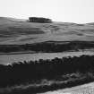
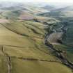
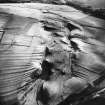
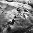
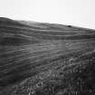
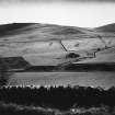
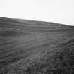
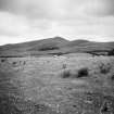
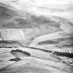
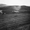
This group of terraces (RCAHMS 1956, Pl.29, figs.192 and 193) occupies an area of about 45 acres on the lower slopes of Braemoor Knowe, overlooking the junction of the Hownam Burn with the Kale Water and extending rather farther to SW and SSE than is shown on the OS map. In the latter region it joins up with faint traces of terracing which extend for some distance up the right bank of the Hownam Burn. The group is generally named after Hownam Law, but this is misleading as the summit of Hownam Law is nearly a mile distant. The hillside, which faces from NW to SW, is crossed obliquely from SSE to NNW, and is considerably broken up by two gullies; the terraces are in consequence irregularly disposed and vary greatly in depth and steepness. They are also in different states of preservation, those on the more accesible parts of the area having been damaged by later cultivation. The limits of elevation of the group are about 430ft and 680ft above sea-level.
While a minutely detailed description of all the terraces is hardly called for, particularly as dimensions vary according to the lie of the ground, the following points shold be noted.
(1) Many of the wider terraces and those on the less steep ground, for instance those lying NW of the plantation, bear longitudinal rigs.
(2) It is virtually impossible to draw any hard and fast line between rigs and terraces, as rigs that run with the contours, or that do not diverge from them at too great an angle, appear to turn into terraces wherever the slope becomes sufficiently steep. This is particularly noticeable at the head and on the E side of the S gully near its lower end, as well as on the E side of the N gully; while the oblique rigs occuring W of the N gully have the appearance of terraces when seen from a distance.
(3) Terraces running out on the steep E side of the N gully show curved points such as have been noted also at Buchtrig (RCAHMS 1956, No.373) and on the Elghope Burn (No. 726).
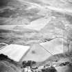
(4) There appears to be a distinction between the terraces lying NW of the plantation and those lying W of it, as the latter are at right angles to the former and end squarely against them.
(5) The best marked of the terraces are six lying below and to the W of the plantation; one of these has a negative lynchet at least 10ft high, and its positive lynchet, which is 15ft in greatest breadth, shows signs of having been broadened at one end by the cutting back of the negative lynchet.
This group is a very striking object when seen from across the Kale Water, it being possible to count a series of no less than twenty-three terraces lying one above another on the bluff to the NW of the plantation.
RCAHMS 1956, visited 13 July 1938.
Rigs, not terraces, ending in similar curved points can be seen at Tullymurdoch, Perthshire.
A Graham 1939.
As described.
Visited by OS (EGC) 13 June 1968.
Visible on Ordnance Survey large scale vertical air photographs (OS 68/027/033 and 058-60).
Information from RCAHMS (RJCM), 27 September 1987.
Publication Account (1985)
The spectacular terraces on the lower westerly slopes of Braemoor Knowe cover some 18 ha. They stretch from about 130m to 210m up the hillside. Seen from the road there no less than 23 terraces, one above the other, on the bluff north-west of the little plantation. Elsewhere, the hillside is cut through by two gullies, so that the terraces lie on different axes and vary in depth and steepness. The most prominent are six lying below and to the west of the plantation; others, running on to the steep east side of the north gully, have curved points. Many of the wider terraces, and those on the gentler slopes, incorporate longitudinal rigs.
Information from 'Exploring Scotland's Heritage: Lothian and Borders', (1985).
Sbc Note
Visibility: This is an upstanding earthwork or monument.
Information from Scottish Borders Council

