
Scheduled Maintenance
Please be advised that this website will undergo scheduled maintenance on the following dates: •
Tuesday 3rd December 11:00-15:00
During these times, some services may be temporarily unavailable. We apologise for any inconvenience this may cause.
Woden Law


Linear Earthwork (Period Unassigned)
Site Name Woden Law
Classification Linear Earthwork (Period Unassigned)
Canmore ID 58139
Site Number NT71SE 8
NGR NT 7686 1279
NGR Description NT 7686 1279 to NT 7693 1291
Datum OSGB36 - NGR
Permalink http://canmore.org.uk/site/58139


- Council Scottish Borders, The
- Parish Hownam
- Former Region Borders
- Former District Roxburgh
- Former County Roxburghshire
NT71SE 8 7686 1279 to 7693 1291.
(NT 7686 1279 - NT 7693 1291) Earthwork (NR)
OS 6" map, (1962).
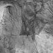
Near the head of the valley down which Dere Street descends to Tow Ford, 250 yds W of Woden Streethead, there amy be seen two fragments of a massive linear earthwork consisting of a bank 17' - 21' thick at the base with a ditch about 11' broad on each side. The fragments are separated by a gap 316' wide situated at the bottom of the valley; the one on the N slope is 50' long, and that on the S, 100'; as each runs directly downhill they are not precisely in alinement. The bottom of the valley is marshy, but the drier parts of the gap are traversed by Dere Street and associated hollow traffic-tracks. This earthwork was probably a boundary-marker, the width of the gap being due to traffic and extensive washouts in the valley itself.
RCAHMS 1956, visited 1938 and 1945.
As described above.
Visited by OS (WDJ) 13 September 1960.
No change.
Visited by OS (BS) 7 September 1976.
Field Visit (24 September 1999)
NT71SE 8
Old Streethouse
Linear Earthwork
NT 76921 12913
OS 1:10,000 map, 1987.
This site was recorded as part of the Kale Water Survey project and is largely as described in the 1956 inventory on the date of visit. The discontinuous remains of this linear earthwork can be traced running N–S across the valley between Langside Law and Woden Law. The northernmost stretch of bank measures 19m in length (from NT 76927 12920 to NT 76914 12907). There is a gap of about 79m between this and the S bank where a track running from E to W passes through. The southern length of bank can be traced for 33m (from NT 76873 12838 to NT 76864 12805).
Recent aerial photographs show there may have been a parallel bank and ditch about 20m to the E at the S end of the earthwork, as indicated on the 1987 edition of the OS 1:10,000 map.
Visited by RCAHMS (MFTR) 24 September 1999, with additional information from RCAHMS (BM) 14 June 2012
Sbc Note
Visibility: This is an upstanding earthwork or monument.
Information from Scottish Borders Council

