
Pricing Change
New pricing for orders of material from this site will come into place shortly. Charges for supply of digital images, digitisation on demand, prints and licensing will be altered.
Huntfold Hill


Fort (Period Unassigned), Sheepfold (Period Unassigned)
Site Name Huntfold Hill
Classification Fort (Period Unassigned), Sheepfold (Period Unassigned)
Canmore ID 58091
Site Number NT71SE 36
NGR NT 7963 1472
Datum OSGB36 - NGR
Permalink http://canmore.org.uk/site/58091


- Council Scottish Borders, The
- Parish Hownam
- Former Region Borders
- Former District Roxburgh
- Former County Roxburghshire
NT71SE 36 7963 1472.
(NT 7963 1472) Fort (NR)
OS 6"map, (1962).
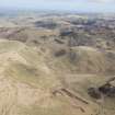
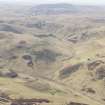
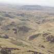
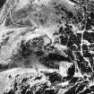
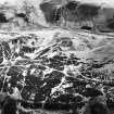
The remains of a small, multivallate, Iron Age fort in which two, and possibly three, constructional phases can be discerned, occupy a strong position at the SW end of the summit of Huntfold Hill. The first phase is represented by ramparts IA, IB, and IC (see RCAHMS 1956 plan fig. 195) which enclose a pear-shaped area, 200' NE-SW by 170'. Ramparts IA and IB appear to have been continuous, although there is a gap of 120' in the latter on the SE side and a lesser gap on the NW, but rampart IC only extends across the vulnerable NE front. In the NE half the defences are fairly well preserved, but in the SW half IA and IB are reduced to crest-lines, separated by a terrace representing the filled ditch, or have merged into a single scarp. All three ramparts evidently consisted of an earth-and-rubble core faced with drystone walling; the facings have mostly been removed to build the sheep-fold which occupies the SE half of the interior of the fort. One entrance is situated on the SE side near the E corner; a second entrance, on the opposite side, is unlikely to be original, and may be a product of the hypothetical third phase discussed below. The whole of the interior of the fort has been disturbed, but traces of three or possibly four hut circles are visible, while slight stone foundations, of no definite plan, occur immediately behind the inner rampart between the SW apex and the circular stell.
In the second phase, the fort was enlarged and strengthened by the addition of ramparts IIA and IIB. Both were built of earth and rubble derived from scoops and ditches along their course, but they are now reduced to low grassy mounds or crest-lines. Two boulders set in the external face of IIA suggest the presence of dry walling, but no stonework is visible in IIB.
That the system represented by ramparts IIA and IIB is secondary is clearly shown by the pronounced kink on the NW side of rampart IIA where it swings out to avoid the earlier defences. On the other hand the two systems are evidently related, since the entrance through the new defences is sited to conform with the approach to the SE entrance of the earlier fort. The change consequently reflects no more than a development of the original scheme of fortification occurring within a single occupational period.
What may be a third phase is suggested by a thick spread of loose stones which covers the N angle of rampart IA. These stones are smaller than those used in the facings and recall the packing of the solid stone walls at Rubers Law fort and the Dunion. It is conceivable therefore that they represent the rebuilding of the rampart to form an entirely new fort or settlement, with a single enclosure wall, at a time when the enlarged fort was in ruins. If this is so, some or all of the internal structures may belong to the latest phase, while a general reconstruction would have provided a suitable occasion for the construction of the entrance of the NW side. That the entrance is not simply a recent break, designed to give access to the sheep-fold, is shown by the fact that it leads into an excavated court, circular, and 40' in diameter.
RCAHMS 1956, visited 1947.
As described above.
Visited by OS (WDJ) 7 September 1960.
A fort as planned and described by RCAHMS. It has three clearly visible hut circles and a possible fourth within its interior but no trace of other foundations.
Visited by OS (BS) 1 September 1976.
Field Visit (9 March 2000)
NT71SE 36
Huntfold Hill
Fort
NT 79624 14721
This site was recorded as part of the Kale Water Survey project and is largely as described in the 1956 inventory on the date of visit. This multivallate fort occupies the summit of Huntfold Hill. Oval on plan, it measures 63m from NE to SW by 58m transversely. There are three inner ramparts, two of which are continuous whilst the third can only be traced around the NE side. Beyond the inner ramparts are two outer ramparts that enclose an area to the NE of the inner fort and are possibly from a later phase of construction. The SE half of the interior is occupied by a drystone sheepfold, much of the material for its construction having come from the stone and turf ramparts of the fort. Traces of at least four houses are visible within the interior, each comprising a stone and turf ring-bank up to 0.5m high and 1.8m thick, the largest of which measures 7.3m in overall diameter.
(KALE99 264-267, 354)
Visited by RCAHMS (PJD) 9 March 2000
Note (9 September 2015 - 3 August 2016)
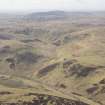
This fort is situated on Huntfold Hill, a steep-sided spur above the Yett Burn into which the ground gently shelves from the saddle between Whitestone Hill and Thorny Hill. on the NNE. The defences of the fort comprise two elements, namely a multivallate inner enclosure and an outer annexe, the latter apparently an addition. The inner enclosure is roughly oval on plan, measuring 63m from NNE to SSW by 58m transversely (0.27ha) within three stone-faced ramparts with external ditches, which form a clearly-defined belt 21m deep around the northern quarter. As they survive today, however, only the inner forms a complete enclosure, the outer ramparts petering out along the flanks, and while the medial rampart is probably represented by a scarp extending around the nose of the spur, the third rampart visible on this side probably belongs to the annexe defences. The latter are best defined on the NE, where they comprise twin ramparts with a medial ditch, but their lines can be traced along the E flank of the fort and they probably once formed a near continuous circuit. While there is no visible stratigraphical relationship between the defences of the fort and those of the annexe, on the NW the inner rampart of the annexe apparently diverts around the outermost rampart of the fort, but it should be noted that its perimeter in this sector has lost the coherence visible on the NE, the outer rampart with an internal ditch splaying to the W, and the inner flanked by discontinuous quarry ditches on either side for a short distance before it diverts. In short, an earlier perimeter, perhaps incomplete, may have been altered here, possibly creating a misleading impression of the relationship between the two. Including the fort, the overall area enclosed by the annexe defences is roughly oval and measures about 125m from NNE to SSW by 75m transversely (0.8ha), extending some 30m beyond the fort defences on the NNE to enclose a crescent-shaped space of about 0.22ha. The interior of the annexe is featureless, but within the fort, the eastern half of which is occupied by a later sheepfold, there are at least four stone-founded round-houses. There are two entrances, on the ESE and WNW respectively, though in 1947 RCAHMS investigators were reluctant to believe that the latter, which opens into a circular scooped court was original to the fort, and attributing it to a hypothetical later period of fortification; if not original, it is more likely to relate to the late Iron Age occupation represented by the stone-founded round-houses. The entrance on the ESE is approached from the E by a trackway through a gap in the annexe perimeter.
Information from An Atlas of Hillforts of Great Britain and Ireland – 03 August 2016. Atlas of Hillforts SC3414
Sbc Note
Visibility: This is an upstanding earthwork or monument.
Information from Scottish Borders Council

