
Hunthall Hill (Dere Street)


Linear Earthwork(S) (Period Unassigned)
Site Name Hunthall Hill (Dere Street)
Classification Linear Earthwork(S) (Period Unassigned)
Canmore ID 58075
Site Number NT71SE 21
NGR NT 772 121
Datum OSGB36 - NGR
Permalink http://canmore.org.uk/site/58075


- Council Scottish Borders, The
- Parish Hownam
- Former Region Borders
- Former District Roxburgh
- Former County Roxburghshire
NT71SE 21 771 120
See also NT71SE 49.
(Name: NT 7717 1205) Earthworks (NR)
OS 6"map, (1962).
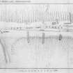
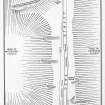
Five linear earthworks, one of which is described on NT71SE 49, span the neck that runs between Hunthall Hill and Woden Law.
The SW end of earthwork 'A' (see RCAHMS 1956, plan, fig.221) begins as a shallow excavation descending the rocky face of a knoll; as it descends this cutting swings N and NE and deepens to become a shallow ditch running NE across the neck. From the point where it turns NE it is backed by a low upcast bank on its NW, or downhill, side. In the centre of the neck bank and ditch are interrupted for 81", Dere Street and its tracks passing through the gap. NE of the gap the work continues as far as the edge of the neck, where it dies out on the lip of the steep descent to Twise Hope. The NE end of the ditch bears a narrow upcast bank on its SE side. This earthwork is probably a substantial boundary mark, erected across a frequented route, its upturned SW end being perhaps intended to indicate the direction of the boundary line across rocky ground where no mound or ditch could be made. Earthworks 'B', 'C', and 'D' lie respectively 90, 140, and 190 yds SE of NT71SE 49, and each consists of a low, widely spread bank with traces of a ditch on its SE side, extending from the SW side of Dere Street for a short distance down the slope forming the head of White Hope. Very faint traces of their NE ends appear on the opposite side of Dere Street, on the lip of the steep descent to Twise Hope. Excavation of 'B' has shown that it is later than the Roman road (Information from Sir W de L Aitchison), but it is also clear that they antedate some, at least, of the post-Roman traffic that has passed along the neck, as they are scored by faint tracks which lead to breaks in the adjoining barrier RCAHMS 1956, visited 1938 and 1945.
As described above.
Visited by OS (WDJ) 13 September 1960.
No change.
Visited by OS (BS) 7 September 1976.
Field Visit (24 September 1999)
NT71SE 21
Hunthall Hill
Linear Earthwork
NT 77256 12058
This site was recorded as part of the Kale Water Survey project and is largely as described in the 1956 inventory on the date of visit
Visited by RCAHMS (MFTR) 24 September 1999
Aerial Photography (2019)
NT 753 136 Pennymuir Temporary Camps, NT 765 123 Woden Law fort, NT 769 118 Dere Street Roman road and earlier cross-ridge earthworks.
A preliminary photographic trial using a drone camera was carried out over the Roman camps which flank Dere Street (Canmore ID: 83741). Camps A, B and D responded well where the earthworks were unploughed, while an Infra-red filter revealed parts of the perimeter of Camp C where cultivation had removed all surface traces.
Woden Law fort (Canmore ID: 58068) was subjected to vertical photographic scan and 3D modelling; these picked out the ramparts very clearly, as well as some of the extensive cord-rig that covers the slopes immediately below the outermost ‘Roman’ earthworks on the east side.
The Roman road, Dere Street was photographed where it crosses a narrow neck of ground south-east of the fort between Whitehope Cleuch and Twisehope Cleuch; the scan revealed its embankment over five earlier cross-ridge dykes (Canmore ID: 58075, 58105) and tell-tale quarry pits where the road to the south is terraced into the hillside. Part of a nearby palisaded homestead (Canmore ID: 58109) was also included in the survey.
Archive: NRHE (intended); 3D modelling at https://sketchfab.com/3d-models/wodens-law-hill-fort-3b241068ffe0463dad356942d5801711;
Funder: Private individuals
Tony Hunt and John Dent
(Source: DES Vol 20)
Sbc Note
Visibility: This is an upstanding earthwork or monument.
Information from Scottish Borders Council

