
Whitton Loch


Linear Earthwork (Period Unassigned)
Site Name Whitton Loch
Classification Linear Earthwork (Period Unassigned)
Canmore ID 58016
Site Number NT71NW 19
NGR NT 7282 2048
NGR Description NT 7282 2048 to NT 7518 1925
Datum OSGB36 - NGR
Permalink http://canmore.org.uk/site/58016


- Council Scottish Borders, The
- Parish Hownam
- Former Region Borders
- Former District Roxburgh
- Former County Roxburghshire
NT71NW 19 7282 2048 to 7518 1925.
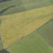
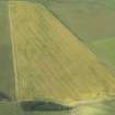
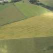
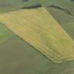
NT 731 205 - NT 751 193. Linear Earthwork, Whitton Loch. This earthwork can first be detected in a cultivated field near the SE side of Craw Cleuch, close to the right bank of the Cessford Burn. It runs SE for 3/4 mile over cultivated land to the boundary dyke dividing Oxnam and Hownam parishes, and thence ESE for 3/4 mile across the moor, passing within 90yds of the S end of Whitton Loch. It can last be traced in the rough marshy ground on the left bank of a tributary of the Beirhope Burn, 1/2 mile W of Beirhope. This course suggests that it bounded one side of a property otherwise defined by the Cessford and Beirhope Burns and the Kale Water.
RCAHMS 1956, visited 1949.
The W terminal of this linear earthwork is not certain but may have been at NT 7282 2048; the E end terminates at about NT 7518 1925. For most of its length the work has been either destroyed or partly so by cultivation and, although it may be archaeologically interesting, it is no longer a prominent and coherent topographical feature. Probably the best preserved stretch is at NT 7410 1971 where it consists of double banks with a medial ditch. The banks here are 4.0m apart between centres, the N bank being 3.5m wide and 0.4m high, the S bank 2.0m wide and 0.2m high, and the ditch 0.4m deep. Elsewhere the S bank appears only intermittently.
Visited by OS (EGC) 28 May 1968.
Sbc Note
Visibility: This is an upstanding earthwork or monument.
Information from Scottish Borders Council

