
Pricing Change
New pricing for orders of material from this site will come into place shortly. Charges for supply of digital images, digitisation on demand, prints and licensing will be altered.
Scheduled Maintenance Notice
Please be advised that this website will undergo scheduled maintenance starting on Thursday, 30th January at 11:00 AM and will last until Friday, 31st January at 10:00 AM.
During this time, the site and certain functions may be partially or fully unavailable. We apologise for any inconvenience this may cause.
Chatto Craig


Cultivation Terrace (Period Unassigned), Rig And Furrow (Medieval) - (Post Medieval)
Site Name Chatto Craig
Classification Cultivation Terrace (Period Unassigned), Rig And Furrow (Medieval) - (Post Medieval)
Canmore ID 57939
Site Number NT71NE 25
NGR NT 7674 1700
Datum OSGB36 - NGR
Permalink http://canmore.org.uk/site/57939


- Council Scottish Borders, The
- Parish Hownam
- Former Region Borders
- Former District Roxburgh
- Former County Roxburghshire
NT71NE 25 7674 1700.
NT 768167. Cultivation terraces, to NE, E and SE of Chatto Craig fort.
RCAHMS 1956.
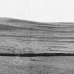
About a dozen distinct, but wasted, cultivation terraces, generally with scarps about 1.0m high and working areas as wide as 2.0m.
Visited by OS (RD) 23 May 1968.
This well-defined and generally impressive group of cultivation terraces occupy approximately 15 hectares of the easterly hillslope centred at NT 7674 1700.
(Visible on RAF photographs: 106G/ Scot/ UK 121:4340, flown 1946).
Visited by OS (MJF) 30 October 1979.
This group of cultivation terraces is also visible on vertical air photographs (OS 68/024/66-7, 84 flown 1968).
Information from RCAHMS, 1997.
Field Visit (February 2000)
NT71NE 25
Chatto Craig
Cultivation Terraces; Rig and Furrow
NT 7674 1700
Hownam
This site was recorded as part of the Kale Water Survey project and is largely as described previously. A series of cultivation terraces are located in an area of rig and furrow on the E-facing slopes of Chatto Craig and Harbour Knowe. Several plots of broad curvilinear rig can be observed extending over an area of about 20ha, around Chatto Craig, from the NW to the SE scarps. The rig, which is generally aligned along the contour, is defined by deep furrows and often subdivided by shallow grooves. A field bank separates the cultivation remains from those further to the SW (NT71NE101- *see above entry*). A plot of broad curvilinear rig, defined by shallow grooves (centred at NT 7651 1674), overlies the earlier rig and the field bank about 200m to the NW of Chatto Craig Fort (NT71NE 43).
Several lengths of turf bank lie on the N slopes of Chatto Craig and may form part of a larger field system.
Visible on vertical aerial photographs OS 68/024/083
Information from RCAHMS (MFTR) February 2000
Sbc Note
Visibility: This is an upstanding earthwork or monument.
Information from Scottish Borders Council

