
Following the launch of trove.scot in February 2025 we are now planning the retiral of some of our webservices. Canmore will be switched off on 24th June 2025. Information about the closure can be found on the HES website: Retiral of HES web services | Historic Environment Scotland
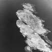
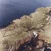
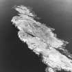
Isle Of May


Midden (Period Unassigned), Village (Period Unassigned)
Site Name Isle Of May
Classification Midden (Period Unassigned), Village (Period Unassigned)
Alternative Name(s) May Island
Canmore ID 57874
Site Number NT69NE 2
NGR NT 6592 9895
Datum OSGB36 - NGR
Permalink http://canmore.org.uk/site/57874


- Council Fife
- Parish Anstruther Wester
- Former Region Fife
- Former District North East Fife
- Former County Fife
NT69NE 2 6592 9895.
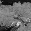
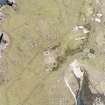
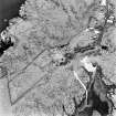
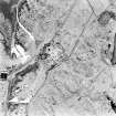
(NT 6592 9895) Site of Village (NR)
OS 6" map (1921)
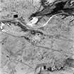
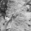
Immediately S of the ruins of the chapel (NT69NE 1) is the site of a fishing village which existed here some centuries ago. Only small portions of the foundations of the houses survive. The site forms part of the cultivated ground of the Isle of May; ashes and other debris are frequently turned up. A small cemetery was connected with the village. A single tombstone, dated 1730, marks the grave of the last villager to die on the island.
Name Book 1853; J Dickson 1899
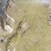
There is an extensive late medieval kitchen-midden containing pottery, charcoal and bones, less than 50 yds S of the chapel.
RCAHMS 1933, visited 1927
The only obvious indications of a village are the later additions to the chapel (see NT69NE 1). The kitchen-midden noted by RCAHMS is visible as a generally overgrown low spread of ashes containing a scattering of charcoal, bones and pottery. About 350m WNW of the chapel is the tombstone mentioned by Dickson. It is earthfast but the top half has fragmented and is lying on the ground. No date can be deciphered. The immediate surrounding area is fairly level but otherwise there are no traces of a graveyard.
Tombstone surveyed on 1/10 000 and annotated Stone (NAT)
Visited by OS (JM) 1 October 1975.
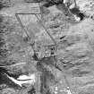
NT 6588 9900 Trial trenches were cut into the very large kitchen midden to the S of the priory. This was a rescue assessment funded by Historic Scotland, to investigate the rabbit disturbance to the historic midden which dates from the medieval period through to the 18th century. The assessment indicated that the rabbit burrowing was very severe, and that the archaeological value of the midden is almost nil. A deeply buried primary soil was encountered above bedrock which was sampled.
NT 6592 9895 Records indicate that following the final abandonment of the Priory (NT69NE 1) in the mid 16th century that a village was planned just to the S. The village was still occupied into the 18th century. Two trenches were cut; in one was the dge of a ditch and in the other unexpectantly a large sherd of Iron Age pottery, along with a fragment of polished stone axe were uncovered.
H James and P Yeoman 1992.
NT 6592 9895 Post-medieval village site: Further geophysical survey work was undertaken by GUARD on the area where the 16th-century village is believed to be located. The results consisted of very low readings but some anomalies were indicated, and these will be investigated in 1994.
H James and P Yeoman 1993.

