
Scheduled Maintenance
Please be advised that this website will undergo scheduled maintenance on the following dates: •
Tuesday 3rd December 11:00-15:00
During these times, some services may be temporarily unavailable. We apologise for any inconvenience this may cause.
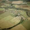
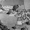
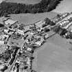
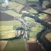
Stenton, General


Village (Period Unassigned)
Site Name Stenton, General
Classification Village (Period Unassigned)
Canmore ID 57833
Site Number NT67SW 37
NGR NT 6207 7407
NGR Description Centred on NT 6207 7407
Datum OSGB36 - NGR
Permalink http://canmore.org.uk/site/57833


- Council East Lothian
- Parish Stenton (East Lothian)
- Former Region Lothian
- Former District East Lothian
- Former County East Lothian

