
Whittingham, General


Village (Period Unassigned)
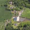
Site Name Whittingham, General
Classification Village (Period Unassigned)
Alternative Name(s) Whittinghame; Luggate Burn
Canmore ID 57807
Site Number NT67SW 13
NGR NT 60198 73601
Datum OSGB36 - NGR
Permalink http://canmore.org.uk/site/57807


- Council East Lothian
- Parish Whittingehame
- Former Region Lothian
- Former District East Lothian
- Former County East Lothian
NT67SW 13 602 736.
Whittingham village (now Luggate Burn: NT 600 742) was built about 28 years ago (1825) by Mr Balfour who completely destroyed the old village in order to enlarge his demesne.
Name Book 1853
A small village stood a short distance SE of Whittingehame parish church (NT 602 736) until 1817, when it was removed by James Balfour. It had 141 inhabitants in 1792, and also contained many untenantable houses which were being pulled down at that time.
C P Snodgrass 1953
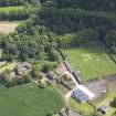
Field Walking (2002)
NT 604 738 Fieldwalking in the Doocot Park field on the site of the village of Whittingehame produced evidence for the layout and longevity of this ‘lost’ village. With volunteers from the East Linton Historical Society, the field was examined in February and October 2001 to determine the extent of surviving archaeology. The SE corner of the field produced a range of pottery from 12thcentury White Gritty wares to 19th-century wares and artefacts. (The village was demolished in the 1820s.) A clear correlation with a plan of the village dated to the 1820s was observed, as
was a concentration of earlier pottery extending from the survey area towards the W along a natural ridge towards the castle of Whittingehame.
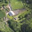
The second fieldwalk was situated in the NE of the field and produced very little in the way of early pottery, showing that the early village was probably situated along the ridge, rather than down towards the N, which suggests later expansion. During this survey a unique clay pipe bowl fragment was discovered bearing the Scottish coat of arms. This was dated to 1822 and the visit of
George IV to Edinburgh in that year. Further fieldwalking is intended to clarify the extent of the various phases of the village, which may indeed date back to the 7th century, as it is linked closely to an early church (c AD 632) located to the N at NT 601 745.
Sponsor: East Linton Historical Society.
D Connolly 2002

