
Pricing Change
New pricing for orders of material from this site will come into place shortly. Charges for supply of digital images, digitisation on demand, prints and licensing will be altered.
Black Loch


Settlement (Period Unassigned)
Site Name Black Loch
Classification Settlement (Period Unassigned)
Canmore ID 57797
Site Number NT67SE 4
NGR NT 66737 73084
Datum OSGB36 - NGR
Permalink http://canmore.org.uk/site/57797


- Council East Lothian
- Parish Spott (East Lothian)
- Former Region Lothian
- Former District East Lothian
- Former County East Lothian
NT67SE 4 NT 66737 73084
(NT 6667 7312) Fort (NR) (Site of)
OS 6" map (1853)
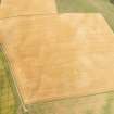
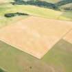
The site of a fort defaced by cultivation, the site having been indicated by a local shepherd.
Name Book 1853
No trace of this fort can be seen in a field under crops. The site lies on the crest of a ridge running roughly E-W and is a likely site for a fort.
Visited by OS (WDJ) 24 March 1966
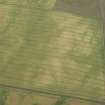
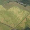
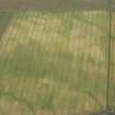
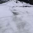
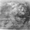
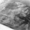
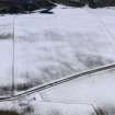
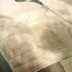
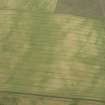
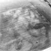
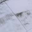
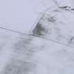
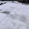
Enclosure, Black Loch: visible on aerial photographs taken in 1977.
(Undated) information in NMRS.
Scheduled as Black Loch, enclosure.
Information from Historic Scotland, scheduling document dated 1 November 1993.
This enclosure, which is visible as a cropmark on aerial photographs, is located below the summit of a hill 18m to the E of a modern fence and some 430m to the SSE of Black Loch. An area measuring about 65m from N to S by 50m transversely is enclosed by a broad ditch broken by opposing entrances to the E and W respectively. The site is comparable to other enclosures found in the cropmark record in East Lothian, the majority of which are undoubtedly settlements.
Information fron RCAHMS (ARG) 10 October 1997.

