
Spott Farm


Linear Feature(S) (Period Unassigned), Track(S) (Period Unassigned)
Site Name Spott Farm
Classification Linear Feature(S) (Period Unassigned), Track(S) (Period Unassigned)
Canmore ID 57788
Site Number NT67SE 16
NGR NT 67040 74780
NGR Description Centred on NT 67040 74780
Datum OSGB36 - NGR
Permalink http://canmore.org.uk/site/57788


- Council East Lothian
- Parish Spott (East Lothian)
- Former Region Lothian
- Former District East Lothian
- Former County East Lothian
NT67SE 16 NT 67040 74780
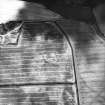
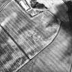
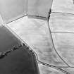
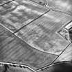
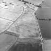
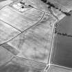
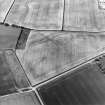
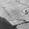
At least three linear cropmarks of sinuous form, running NNE and SSW and visible for a length of over 150m, were recorded on sloping ground during aerial survey (RCAHMSAP) in an area with geological cropmarking. Their function is uncertain, but they may be the cropmarks of a braided trackway. A broad linear cropmark is recorded running from about 100m WNW and ESE across these features before apparently turning at a near-right angle and continuing as a narrower cropmark for about 100m.
Information from RCAHMS (MMB) 21 December 2004

