
Pricing Change
New pricing for orders of material from this site will come into place shortly. Charges for supply of digital images, digitisation on demand, prints and licensing will be altered.
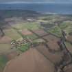
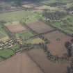
Tyninghame, General


Burgh (Medieval), Village (Period Unassigned)
Site Name Tyninghame, General
Classification Burgh (Medieval), Village (Period Unassigned)
Alternative Name(s) Tyninghame Estate
Canmore ID 57773
Site Number NT67NW 60
NGR NT 6095 7907
NGR Description Centred NT 6095 7907
Datum OSGB36 - NGR
Permalink http://canmore.org.uk/site/57773


- Council East Lothian
- Parish Whitekirk And Tyninghame
- Former Region Lothian
- Former District East Lothian
- Former County East Lothian
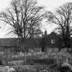
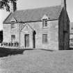
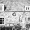
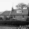
Photographic Survey (August 1961)
Photographs of buildings in Tyninghame village, East Lothian, by the Scottish National Buildings Record in 1961.

