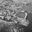
|
Photographs and Off-line Digital Images |
B 97037 CS |
RCAHMS Aerial Photography |
General aerial view of Dunbar Town from the NE, overlooking Victoria Harbour (NT67NE 147) and the castle remains (NT67NE 8). |
27/7/1994 |
Item Level |
|
|
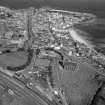
Photographs and Off-line Digital Images |
D 16605 CN |
RCAHMS Aerial Photography |
Oblique aerial view of Dunbar taken from the SE. Also visible is the Bass Rock and the coast of Fife. |
4/8/1997 |
Item Level |
|
|
Photographs and Off-line Digital Images |
D 16604 CN |
RCAHMS Aerial Photography |
Oblique aerial view of Dunbar taken from the SE. Also visible is the Bass Rock and the coast of Fife. |
25/7/1997 |
Item Level |
|
|
Print Room |
B 27443 PC |
|
Postcard showing general view.
Insc: 'Dunbar'. |
1935 |
Item Level |
|
|
Print Room |
EL 5095 |
Papers of Sir Howard Montagu Colvin, architectural historian, Oxford, England |
Historic photograph.
General view from church tower from SE. |
c. 1880 |
Item Level |
|
|
Print Room |
EL 5096 PO |
Papers of Sir Howard Montagu Colvin, architectural historian, Oxford, England |
Historic photograph.
General view from NW. |
c. 1880 |
Item Level |
|
|
Print Room |
SMO S/20/14 |
Records of Scott Morton and Company, woodwork designers, Edinburgh, Scotland |
Furnishings, structural components and religious building fixtures for and from locations including probably Falkirk, Cockburn Street, Erskine Church; Musselburgh, Loretto School; probably Dunblane Cathedral; Glasgow, Bothwell Street, unidentified location; Eyemouth, unidentified church; Banff, unidentified location; probably Edinburgh, Candlemaker Row, Greyfriars Church; Edinburgh, Blackhall, Union Bank, unidentified location; Edinburgh, High Street, St Giles' Cathedral, Chapel of Youth; Hutton Church; Alloa, unidentified church; Edinburgh, 2 St Andrew Square; probably Coatbridge, School Street, Whifflet Church of Scotland; Dalmellington, probably Knowehead, Kirk of the Covenant; Perth, Atholl Street, St Ninian's Cathedral; Dunbar, unidentified church; St andrews, unidentified church; Kelso, unidentified church; Glasgow, 113-115 Buchanan Steet, National Commercial Bank; Islay, Port Askaig, Dunlossit House; Dunfermline, unidentified location; Houston Parish Church; possibly Dundee, Broughty Ferry, Mayfield House; Hawick, Lynnwood Road, Lyle and Scott; and ex-Scotland, London, 145 Leadenhall Street.
Sketchbook containing plans, elevations, design details and rubbings including for finials, doors, pews, chairs, screens, panelling, desk, stalls, and staircase. |
c. 1936 |
Item Level |
|
 |
On-line Digital Images |
SC 761510 |
RCAHMS Aerial Photography |
Oblique aerial view of Dunbar taken from the SE. Also visible is the Bass Rock and the coast of Fife. |
25/7/1997 |
Item Level |
|
 |
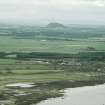
On-line Digital Images |
SC 761511 |
RCAHMS Aerial Photography |
Aerial view including church and harbour. |
1978 |
Item Level |
|
 |
On-line Digital Images |
SC 768919 |
RCAHMS Aerial Photography |
Oblique aerial view. |
1978 |
Item Level |
|
|
Photographs and Off-line Digital Images |
EL 4080 |
|
General view of Hi Spy at full stretch. |
1979 |
Item Level |
|
|
Photographs and Off-line Digital Images |
EL 3737 PO |
Clapperton Studios |
Copy of postcard showing general view. |
c. 1900 |
Item Level |
|
|
Photographs and Off-line Digital Images |
ELD 28/1 P |
Soane Museum Drawings |
Photographic copy of drawing showing design for fireplace. |
|
Item Level |
|
|
Photographs and Off-line Digital Images |
ELD 28/2 P |
Soane Museum Drawings |
Photographic copy of drawing showing design for chimneypiece. |
|
Item Level |
|
|
Photographs and Off-line Digital Images |
ELD 28/3 P |
Soane Museum Drawings |
Photographic copy of drawing showing design for chimneypiece. |
24/10/1791 |
Item Level |
|
|
Photographs and Off-line Digital Images |
ELD 28/3A P |
Soane Museum Drawings |
Photographic copy of drawing showing design for chimneypiece. |
|
Item Level |
|
|
Photographs and Off-line Digital Images |
EL 287 |
|
View of milepost 5 miles SE of Dunbar. |
|
Item Level |
|
 |
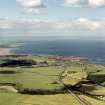
On-line Digital Images |
SC 817864 |
RCAHMS Aerial Photography |
Oblique aerial view, taken from the NE, looking SW from the sea and across the town of Dunbar (NT67NE 96), with Traprain Law fort (NT57SE 1) in the distance. |
15/7/1994 |
Item Level |
|
|
Prints and Drawings |
DC 1595 |
Historic Scotland. Scottish Burgh Survey. |
Working map for DC1593 including table symbols. |
1981 |
Item Level |
|
|
Prints and Drawings |
DC 1596 |
Historic Scotland. Scottish Burgh Survey. |
Working map for DC1594 including table symbols. |
1981 |
Item Level |
|
|
Prints and Drawings |
DC 1592 |
Historic Scotland. Scottish Burgh Survey. |
Map of Dunbar in its national and regional settings. |
1981 |
Item Level |
|
|
Prints and Drawings |
DC 1593 |
Historic Scotland. Scottish Burgh Survey. |
Map of overlay showing archaeological potential. |
1981 |
Item Level |
|
|
Prints and Drawings |
DC 1594 |
Historic Scotland. Scottish Burgh Survey. |
Map of showing listed buildings, conservation area and monument sites. |
1981 |
Item Level |
|
|
Prints and Drawings |
DC 8335 |
Records of the Royal Commission on the Ancient and Historical Monuments of Scotland (RCAHMS), Edinbu |
Drawing showing map of Dunbar and the coast of East Lothian, map of Dunbar and Belhaven about 1755 after Roy and reconstruction plan of upper floor of the Custom House, Dunbar. |
c. 1966 |
Item Level |
|


