
Battle Of Dunbar


Battle Site (17th Century)
Site Name Battle Of Dunbar
Classification Battle Site (17th Century)
Canmore ID 57658
Site Number NT67NE 54
NGR NT 695 765
Datum OSGB36 - NGR
Permalink http://canmore.org.uk/site/57658


- Council East Lothian
- Parish Dunbar
- Former Region Lothian
- Former District East Lothian
- Former County East Lothian
NT67NE 54 695 765.
(NT 703 767) Site of Battle of Dunbar (NR) 3rd September 1650.
OS 6" map (1957)
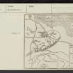
The Battle of Dunbar was fought between the Parliamentarians under Cromwell and the Covenanters under General Leslie, on the 3rd of September 1650. The Covenanters were defeated.
The orthodox view is that the main action took place where the London road crosses the Brocksburn, at NT 6935 7724, but Firth, interpreting a pictorial plan of the battle based on information from participants, sites the main centre of conflict about a mile away, between the road and Doon Hill (NT 685 756) on which Generl Leslie had his camp (NT67NE 50). Firth's view is supported by The Statistical Account [OSA] recording of the local name as the Battle of Doon Hill and placing its centre north and east of the hill.
Despite the OS siting (Name Book 1853), the area around NT 695 765 would appear to be a more accurate siting for the battle.
C H Firth 1900; OSA 1794
No further information.
Visited by OS (RD) 22 March 1966
(NT 696 765) Site of Battle of Dunbar (NR)
OS 6" map (1971)
Brander gives a description of the battle, and his plan confirms the OS siting (1971).
M Brander 1975
This battlefield was included in a nation-wide study of key battle sites. A detailed gazetteer was created by The Battlefield Trust, which includes an historical overview of each site, detailed assessments of the action and its location and the number of troops involved, casualties, sources of information and an interpretation of the events and its impact on history. For more detail see the gazetteer and associated materials - MS 2522.
Extensive quarrying in very recent times, and which still continues today, has completely destroyed a substantial area on the critical eastern side of the battlefield, without apparently any form of archaeological recording of this important resource before destruction. Further damage was caused by the mainline railway line and the realignment of the A1.
G Foard, T Partida 2005

