
Pricing Change
New pricing for orders of material from this site will come into place shortly. Charges for supply of digital images, digitisation on demand, prints and licensing will be altered.
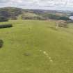
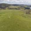
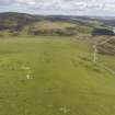
Kingside Hill


Enclosure (Period Unknown)
Site Name Kingside Hill
Classification Enclosure (Period Unknown)
Canmore ID 57548
Site Number NT66SW 24
NGR NT 632 649
NGR Description NT c. 632 649
Datum OSGB36 - NGR
Permalink http://canmore.org.uk/site/57548


- Council East Lothian
- Parish Whittingehame
- Former Region Lothian
- Former District East Lothian
- Former County East Lothian
NT66SW 24 c. 632 649.
Forrest's Map indicates a 'Camp' on Kingside Hill (NT 632 649). No remains of it can now be discerned, and no information concerning it was obtained from local enquiries.
W Forrest 1801; Name Book 1853.
Note (5 December 2019)
The location, classification and period of this site have been reviewed.

