
Craigie Wood


Barmkin (Medieval), Tower House (Medieval)
Site Name Craigie Wood
Classification Barmkin (Medieval), Tower House (Medieval)
Alternative Name(s) Rathburne House, Tower House And Barmkin
Canmore ID 57411
Site Number NT65NE 6
NGR NT 68350 57232
NGR Description Centre
Datum OSGB36 - NGR
Permalink http://canmore.org.uk/site/57411


- Council Scottish Borders, The
- Parish Longformacus
- Former Region Borders
- Former District Berwickshire
- Former County Berwickshire
NT65NE 6 6834 5722
(NT 6834 5722) Peel (NR) (site of)
OS 6" map, Berwickshire, 2nd ed., (1908).
Tower [NR]
(Remains of) [NAT
OS 1:10,000 map, 1982.
See also NT65NE 13.
Traditionally a tower of considerable strength, which belonged to the Sinclairs, stood here.
Name Book 1857.
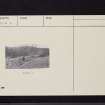
The much-scattered remains of a four-sided courtyard wall of unmortared rubble masonry, 1.3m in maximum height, enclose a confused mass of earth and stones which cover the remains of the tower. The probable E wall can just be traced as a faint course, thus making the structure approximately 12.0m by 11.0m. The site is defended on the S and SW by precipitous slopes to the river; the rest of the site was protected by a ditch, now considerably silted up.
Visited by OS (JFC) 16 December 1954.
As described in the previous field report. The shallow ditch, 6.0m average width, is most pronounced on the E side of the tower, but fades out to the NW.
Revised at 1/2500.
Visited by OS (WDJ) 30 October 1963.
The probable remains of a tower, possibly the predecessor of that described on NT65NE 13.
H M Brown 1959; RCAHMS 1980, visited 1979.
Scheduled as 'Rathburne House, tower house 180m NW of... the ruined remains of a rectangular tower and its associated barmkin enclosure...'
Information from Historic Scotland, scheduling document dated 30 March 2009.
Note (6 January 2020)
The location, classification and period of this site have been reviewed.
Sbc Note
Visibility: Upstanding building, which may not be intact.
Information from Scottish Borders Council

