
Pricing Change
New pricing for orders of material from this site will come into place shortly. Charges for supply of digital images, digitisation on demand, prints and licensing will be altered.
Wrunklaw


Farmstead (Medieval), Farmstead (Post Medieval), Promontory Fort (Prehistoric)
Site Name Wrunklaw
Classification Farmstead (Medieval), Farmstead (Post Medieval), Promontory Fort (Prehistoric)
Alternative Name(s) Wrinklaw Or, Horseupcleugh
Canmore ID 57391
Site Number NT65NE 1
NGR NT 67246 58425
NGR Description Centre
Datum OSGB36 - NGR
Permalink http://canmore.org.uk/site/57391


- Council Scottish Borders, The
- Parish Longformacus
- Former Region Borders
- Former District Berwickshire
- Former County Berwickshire
NT65NE 1 6722 5845
(NT 6722 5845) Fort (NR)
OS 25" map, (1967)
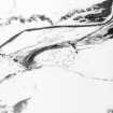
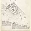
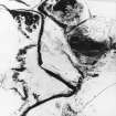
Promontory Fort, Wrinklaw: A fort situated on a promontory, across the neck of which, facing the higher ground on the NW, is a rampart some 4ft to 5ft high, with an entrance near the centre. To the S of this, a trench 10ft to 12ft deep, beyond the termination of the rampart, is continued down the bank at a little distance from the fort. Some 86ft S of the rampart is a second line of defence, comprising a trench some 36ft wide from crest to crest with a mound to the rear of it some 6ft in height. Within the fort are the remains of a number of rectangular foundations in two contiguous rows, all probably connected with some later, secondary occupation.
RCAHMS 1915, visited 1908; D Christison 1895; J Farquharson 1885
A strongly defended promontory, with remains of later farm buildings and enclosures. The site is as described by the previous authorities, except that the initial rampart on the N side of the first ditch has been removed; the maximum depth of the ditch is 3.2m. The maximum depth of the second ditch below the crest of the rampart is 1.5m. The fort is in a very strong position with precipitous slopes on all sides except where defended by its ditches.
Visited by OS (JFC) 15 December 1954
The remains of this promontory fort are generally as previously described. There is now no trace of a ditch E of the entrance at NT 6722 5846. It would appear that the main ditch leads into the top of a gully at NT 6719 5843, the steep slopes on this side being an adequate defence. The interior of the fort has been occupied by a later farmstead, only the footings of which now remain.
Surveyed at 1:2500.
Visited by OS (WDJ) 30 October 1963
The remains of the fort and footings of the farmstead are very well preserved.
Surveyed at 1:10,000.
Visited by OS (MJF) 30 May 1979
The approach to a U-shaped promontory is blocked by a substantial earthen bank accompanied, to the SW of a central entrance, by an external ditch. About 35m to the rear there is a second, much-reduced bank and ditch while there are slight indications of further defences around the tip of the promontory. The inner defences are partly overlain by the stone footings of a number of rectangular buildings and enclosures, probably of late medieval date, including a possible hall. These remains suggest that at this period the site was the residence of a family of lesser baronial status, although the earthwork defences may in part be of earlier medieval date.
RCAHMS 1980, visited 1979
A farmstead annotated Wrinklaw (Remains of), comprising two unroofed buildings and an enclosure, is depicted on the 1st edition of the OS 6-inch map (Berwickshire 1862, sheet ix), but it is not shown on the current edition of the OS 1:10000 map (1982).
Information from RCAHMS (SAH) 14 September 2000
Field Visit (8 October 1908)
248. Promontory Fort, Wrinklaw (Wrunklaw or Runklie).
This fort (fig. 122 [DP 228317]) is situated at the base of the Wrinklaw, on a promontory formed between the Water of Dye and a small stream which flows down a glen on the north-east, some 900 feet above sea-level and 1 ½ miles or thereby distant from the village of Longformacus. The face of the bank overlooking the Dye to the southward is abruptly steep, and has an elevation of about 150 feet, while on the north-east flank the glen of the burn likewise provides a strong natural defence. Across the neck of the promontory facing the higher ground on the northwest there rises a rampart with a height of some 4 to 5 feet, pierced by an entrance near the centre, and to the south of that covered by a trench, 10 to 12 feet deep, which, beyond the termination of the rampart, is continued down the bank at a little distance from the fort. Some 86 feet south of the rampart occurs a second line of defence, a trench some 36 feet wide from crest to crest, with a mound in rear of it some 6 feet in height which curves slightly towards the steep flanks at either end. Within the fort are the remains of a number of rectangular foundations in two contiguous rows, and of other buildings, all probably connected with some late secondary occupation.
See Antiquaries, xxix. p. 156 (plan); Ber. Nat. Club, 1882-84, p. 24.
RCAHMS 1915, visited 8th October 1908.
OS Map: Ber., ix. SW.
Note (26 January 2016 - 4 August 2016)
The remains of this fortification are situated low down on the SW flank of Wrunklaw, on a sloping promontory formed between the steep slope dropping down to the N bank of the Dye Water and a shallow stream gully descending obliquely across the hillside. The site of a farmstead during the late 18th century, which was itself superseded by a shepherd's cottage in the early 19th century, the promontory is occupied by the footings of a series of rectangular buildings and attached yards, but on the NW these override two ramparts and ditches set some 27m apart. These bar access from the NW and the inner may also extend along the SW flank down to the tip of the promontory, enclosing a D-shaped area measuring about 70m from NW to SE along the chord by a maximum of 50m transversely (0.25ha). The outer ditch, which is over 10m broad by 3.5m in depth is visible only on the SW of a central entrance, but at the SW margin of the promontory it opens into an irregular gash that plunges down the slope to the very bottom of the valley. The precise origin of this feature is unclear, cutting across the line of a terraced trackway obliquely mounting the slope; indeed, traces of three trackways can be seen on the slope immediately below the interior, and though their precise relationship to the inner rampart is ambiguous, this appears to have been a long-standing point of access into the interior.
Information from An Atlas of Hillforts of Great Britain and Ireland – 04 August 2016. Atlas of Hillforts SC4039
Note (31 January 2020)
The location, classification and period of this site have been reviewed.
Sbc Note
Visibility: This is an upstanding earthwork or monument.
Information from Scottish Borders Council

