 |
On-line Digital Images |
SC 1746914 |
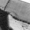
RCAHMS Aerial Photography |
Oblique aerial view of Heckside Plantation, Clinthill centred on the cropmarks of a fort, taken from the E. |
16/7/1999 |
Item Level |
|
|
Photographs and Off-line Digital Images |
SC 1925405 |
Cambridge University Collection for Aerial Photography |
Oblique aerial view. |
1930 |
Item Level |
|
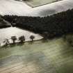 |
On-line Digital Images |
SC 1938746 |
John Dent |
Oblique aerial view. |
1993 |
Item Level |
|
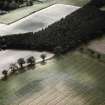 |
On-line Digital Images |
SC 1938747 |
John Dent |
Oblique aerial view. |
1993 |
Item Level |
|
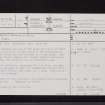 |
On-line Digital Images |
SC 2452568 |
Records of the Ordnance Survey, Southampton, Hampshire, England |
Heckside Plantation, Clinthill, NT63SW 7, Ordnance Survey index card, page number 1, Recto |
c. 1958 |
Item Level |
|
 |
On-line Digital Images |
SC 2452569 |
Records of the Ordnance Survey, Southampton, Hampshire, England |
Heckside Plantation, Clinthill, NT63SW 7, Ordnance Survey index card, page number 2, Verso |
c. 1958 |
Item Level |
|
 |
On-line Digital Images |
SC 2452570 |
Records of the Ordnance Survey, Southampton, Hampshire, England |
Heckside Plantation, Clinthill, NT63SW 7, Ordnance Survey index card, Recto |
c. 1958 |
Item Level |
|
|
All Other |
551 166/1/1 |
Records of the Ordnance Survey, Southampton, Hampshire, England |
Archaeological site card index ('495' cards) |
1947 |
Sub-Group Level |
|


