
Heckside Plantation, Clinthill


Fort (Period Unassigned)
Site Name Heckside Plantation, Clinthill
Classification Fort (Period Unassigned)
Alternative Name(s) Heckside Plantation 1; Clinthill; Clint Lodge; Heckside 1
Canmore ID 57275
Site Number NT63SW 7
NGR NT 6037 3303
Datum OSGB36 - NGR
Permalink http://canmore.org.uk/site/57275


- Council Scottish Borders, The
- Parish Mertoun
- Former Region Borders
- Former District Ettrick And Lauderdale
- Former County Berwickshire
NT63SW 7 6037 3303
(NT 6037 3303) Enclosure (NR) (site of)
OS 6" map, (1967).
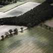
A fort occupies the top of the ridge 350yds N of Clint Lodge, 16yds E of the NE corner of the projection of Hackside Plantation and bisected by a wire fence. The slightly raised remains of a single rampart enclose an oval area, 282ft by 222ft, on cultivated land.
J H Craw 1921.
This oval enclosure, measuring 120m by 80m, has been recently ploughed so that the remains now consist of a low, spread earthen bank about 1.2m wide. There is no sign of an entrance.
Visited by OS (JD), 26 May 1955.
The remains of this enclosure have been almost completely ploughed out.
Surveyed at 1:2500.
Visited by OS (WDJ), 19 September 1962.
Photographed by the RCAHMS.
RCAHMS flown 1976. (see Archive)
CUCAP, who list a settlement at NT 605 331, visible on their air photographs, may be referring to this site.
CUCAP AP catalogue. (see Archive).
(Undated) information in OS records.
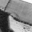
NT 603 330. In 1993 K Clark from the Newstead Research Project surveyed Heckside 1 (NMRS NT63SW 7). Resistivity plots clealry show the south-eastern quadrant of the enclsoure. Visible are two concentric ditches, each with entrances in the SE. Up to four internal features can be seen on the plot, and these are likely to represent structures.
Sponsors: National Museum of Scotland, University of Bradford, British Academy, Borders Regional Council
A L Wise 1995.
Note (23 January 2016 - 15 August 2016)
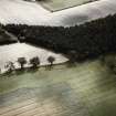
Cropmarks have revealed the ditches of a fort or fortified settlement first recorded about 1921 by James Hewat Craw, situated on a low rise on the broad crest of the hill above Clinthill (See also Atlas No.4027). Oval on plan, the cropmarks show two ditches some 4m broad and set 5m apart, enclosing an area measuring about 85m from ENE to WSW by 65m transversely (0.44ha); allowing for the presence of an inner rampart the interior extends to some 0.35ha. Two circular maculae visible on some photographs indicate the positions of internal round-houses in the S part of the interior, while four anomalies in a geophysical survey of the SE quadrant are probably the remains of structures too (Wise 1995). A causeway across the outer ditch on the E marks the position of the entrance, a mark merging with the inner ditch perhaps reflecting a shallow hollow worn by traffic across the inner causeway.
Information from An Atlas of Hillforts of Great Britain and Ireland – 15 August 2016. Atlas of Hillforts SC4026
Sbc Note
Visibility: This site is visible as a cropmark.
Information from Scottish Borders Council

