
Pricing Change
New pricing for orders of material from this site will come into place shortly. Charges for supply of digital images, digitisation on demand, prints and licensing will be altered.
Upcoming Maintenance
Please be advised that this website will undergo scheduled maintenance on the following dates:
Thursday, 9 January: 11:00 AM - 3:00 PM
Thursday, 23 January: 11:00 AM - 3:00 PM
Thursday, 30 January: 11:00 AM - 3:00 PM
During these times, some functionality such as image purchasing may be temporarily unavailable. We apologise for any inconvenience this may cause.
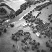
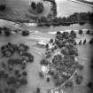
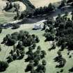
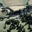
St John's Well, The Law


Holy Well (Period Unassigned)
Site Name St John's Well, The Law
Classification Holy Well (Period Unassigned)
Canmore ID 57197
Site Number NT63SE 16
NGR NT 6738 3144
Datum OSGB36 - NGR
Permalink http://canmore.org.uk/site/57197


- Council Scottish Borders, The
- Parish Roxburgh
- Former Region Borders
- Former District Roxburgh
- Former County Roxburghshire
Eighteenth- and nineteenth-century accounts suggest that there was a well at the base of the hillock named The Law, which lies south of the River Tweed to the north of Roxburgh Newtown.
The well was reportedly a holy well, dedicated to St. John. The remains of a structure were recorded, but no traces can now be identified.
Holy wells, often renowned for their curative properties, were popular sites of pilgrimage in the medieval period, but their use was strongly discouraged by the post-Reformation church.
Text prepared by RCAHMS as part of the Accessing Scotland's Past project
NT63SE 16 6738 3144.
"A well of several streams called 'St. John's' issued from the base of The Law (Roxburgh 9 NE 5) and from the salubrity of the wataer and the remains of a nice building must have been of great repute."
A Jeffrey 1864; Statistical Account (OSA, A Bell) 1797.
No trace of any well or spring was found round the base of the Law. No further information was obtained.
Visited by OS(WDJ) 13 September 1962.
Sbc Note
Visibility: Evidence for this site, or the origins of this site, comes from documentary sources. Nothing may be visible at this location.
Information from SBC.

