
Lanton Moor


Earthwork (Period Unassigned)
Site Name Lanton Moor
Classification Earthwork (Period Unassigned)
Canmore ID 57101
Site Number NT62SW 23
NGR NT 6415 2264
Datum OSGB36 - NGR
Permalink http://canmore.org.uk/site/57101


- Council Scottish Borders, The
- Parish Jedburgh
- Former Region Borders
- Former District Roxburgh
- Former County Roxburghshire
NT62SW 23 6415 2264.
(Centred: NT 6415 2264) Fort (NR).
OS 6" map, Roxburghshire, (1923).
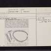
Earthwork, Lanton Moor (2). This simple earthwork (RCAHMS 1956, fig.293), now planted with trees, lies at a height of 550ft OD on the broad and almost level crest of Lanton Moor- a situation of no defensive strength. The earthwork is oval in shape, measuring 230ft from E to W by 155ft transversely. The bank, of heaped earth and stones, was quarried from an external ditch, a few traces of which can be seen where silting and cultvation have not entirely obliterated it. Where best preserved, at the W end, the bank is 4ft high ; there is an entrance-gap in the E end. Outside the W end of the structure there are three separate straight earthen banks, each about 3ft 6in. high, the purpose of which is obscure. The first, which lies about 40ft from the bank of the earthwork, is 130ft in length and runs from NW to SE. The second, lying about 45ft beyond the first and almost parallel to it, is 150ft in length and has a ditch on the SW side. The third, which is 70ft long, lies N of the first and runs from NE to SW.
RCAHMS 1956, visited 18 May 1948.
Miscellaneous Earthworks:
In the absence of excavation, over eighty earth-works in the county cannot be classified either because they do not conform to recognised types or because their plans are not sufficiently distinctive. A few of these, occupying commanding positions on hilltops or the crests of ridges, are unlikely to be later than the 11th century ; such are Bonchester Hill (no.278), the group of earthworks on Whitcastle Hill (no.865), and five roughly D-shaped earthworks lying within a radius of two miles between the River Teviot and the Slitrig Water-Gray Hill 2 (no.999), Birny Knowe (no.995), Crom Rig (no.1000), Dodburn (no.160, ii), and Pen Sike (no.168)-which are characterised by ramparts massive in proportion to their size. The majority, however, are situated on hill-sides or in the bottoms of valleys, generally below the 800ft. contour, and are probably mediaeval. Most of these lower-lying structures, of which the out-standing examples are Timpendean (no.
435), Iron Castle (no.945), and Scraesburgh (no.466), were evidently designed for habitation and presumably contained wooden buildings ; but a few of the simpler earthworks such as Huntly Burn (no.51) may have been enclosures for stock.
RCAHMS 1956.
This earthwork, purpose uncertain, but not defensive, is generally as described by RCAHM. There are vague indications of a possible bank enclosing the earthwork on the N, E and S sides, at a distance of c 12, 40, and 20m respectively from the main enclosing bank; but this was too uncertain in thick undergrowth for survey action.
Re-Surveyed at 1/2500.
Visited by OS (WDJ) 1 February 1967.
Sbc Note
Visibility: This is an upstanding earthwork or monument.
Information from Scottish Borders Council

