
Pricing Change
New pricing for orders of material from this site will come into place shortly. Charges for supply of digital images, digitisation on demand, prints and licensing will be altered.
Mantle Walls


Architectural Fragment (Medieval), Bishops Palace (Medieval)(Possible)
Site Name Mantle Walls
Classification Architectural Fragment (Medieval), Bishops Palace (Medieval)(Possible)
Alternative Name(s) Malton Walls
Canmore ID 57090
Site Number NT62SW 13
NGR NT 6320 2464
Datum OSGB36 - NGR
Permalink http://canmore.org.uk/site/57090


- Council Scottish Borders, The
- Parish Ancrum
- Former Region Borders
- Former District Roxburgh
- Former County Roxburghshire
NT62SW 13 6320 2464.
(NT 6320 2464) Malton or Mantle Walls (LB) (Site of)
OS 6" map, (1957).
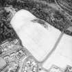
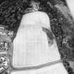
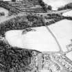
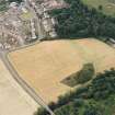
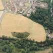
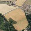
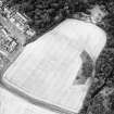
The exact nature of the site is not known, but APs suggest that it has been a castle or palace.
The building, which stood on elevated ground, was a parallelogram in plan (OSA 1794) 100yds E-W by 200 yds N-S (Pococke 1760), enclosing an area of 1 1/2 acres (J Robson 1893) (these two areas are inconsistent - the latter is probably more correct) and was strongly built of stone and lime (OSA 1794) with buttresses (Pococke 1760). Stobie's Map (M Stobie 1770) shows a rectangular enclosure, lying E-W, with a small rectangular annexe at the SE corner. About the middle of the 18th century a high gable, containing a beautiful window, stood next to the tower (A Jeffrey 1864). Vaults or subterranean arches were found beneath and near the area enclosed by the building (OSA 1794).
A good part of the east and north walls still stood in 1760, and the last portion of wall fell in 1837. The outline of the enclosure was still visible in 1857 but nothing now remains.
The Statistical Account (OSA) reported in 1794 that "Human bones are still found by persons ploughing or digging in the plain at the side of the river, which is evidence of its having been previously occupied as a burying-ground." (Possibly associated with AP cropmarks at NT 631 247 or NT 632 243 - (Visible on RAF air photographs CPE/Scot/UK 315: 4218-9, flown 1948).
The torso of a larger than life size crude mediaeval statue was found on the site of 'Mantle Walls' about 1956, by W C Hunter, tenant of Copland Farm, who had previously removed foundation stones from the site. The remains of the statue do not suggest a religious figure, (information in a letter from A A Buist to the National Museum of Antiquities of Scotland (NMAS) 24 April 1956), but most older houses in the neighbourhood seem to have been reinforced with stones from the site, and in the south wall just to the north of it, we saw the remains of a short gravestone inscription dated 1607 (A A Buist 1957).
The only historical evidence which could apply to this site is contained in 12th and 13th century charters (the last being dated 1258) of the Bishops of Glasgow, dated from Ancrum, in which mention is made of the Bishop's house and his chapel, which was independent of the parish church. Since Nether Ancrum (ie Ancrum south of the River Ale) belonged to the Bishop, and Over Ancrum (ie Ancrum north of the River Ale) belonged to the monks of Jedburgh (although this also was in the Diocese of Glasgow), it is probable that the Bishop's residence was in Nether Ancrum, and not at the site of the mid-16th century Ancrum Castle (NT62NW 11) at Over Ancrum, as has been suggested (OPS 1851).
"The Castle of Ancrum" is mentioned in a letter of Lord Dacre to the Bishop of Durham in 1513, and it is possible that this also refers to the "Mantle Wall" since there is no evidence to suggest that a castle stood at Over Ancrum at that time.
Of the alternative names of the site, 'Mantle' is simply an enclosing wall, while 'Maltan' stems from the alleged association with the Knights of Malta - an association which Easson dismisses as unfounded, as also he dismisses the suggestion that this has been a house of the Trinitarians (see also NT62SW47).
Reg Epis Glasguensis 1843; G Watson 1920; D E Easson 1957; RCAHMS 1956.
There are no traces of 'Mantle Walls' visible. Mr W C Hunter of Copland Farm stated that the statue was found during ploughing and that the ploughman had since left the farm. Mr W C Hunter thought that it had been found at approximately NT 6322 2463 but could give no further information. The fragment of gravestone dated '1607' is built into the SW corner of the dwelling-house at NT 6315 2479.
Visited by OS (WDJ) 23 January 1967.
Information to follow.
RCAHMS (KB) 4 July 2000
Field Visit (24 May 1939)
Mantle Walls, or Maltan Walls (Site).
Nothing now remains of this structure, although the outline of the enclosure was still visible in 1857 (THAS 1920, 8). Pococke, writing in 1760, also records (p.344) that “the present walls, of which a good part remains to the east and north, are built with buttresses”. A record of 1794 (Stat. Acct. X, 294 n.) describes the walls as being “strongly built of stone and lime in the figure of a parallelogram” and formerly standing to a considerable height although they had been almost levelled by the time of writing. “Vaults or subterraneous arches” had also been discovered in and near the enclosure, as well as human bones in the fields by the side of the river. The writer goes on to adduce the name “Maltan Walls” in support of “a tradition, generally received in this part of the country, that the building and surrounding fields had been vested in the knights of Malta”; but this is unlikely as Ancrum-Spital was a separate property situated on the E. side of the Ale Water and immediately W. of Monteviot House (Blaue, ‘Teviota’). The Templar lands of Ancrum, again, were recorded in 1649 as being on the estate of Over Ancrum (RMS 1634-51, No. 2025). The “Description of Teviotdale” of 1649 (Geogr. Collections, iii, 158) places a house of Trinitarian or Red Friars at Nether Ancrum; it is true that no such house is included in the list given in the Scotichronicon but this work is not quite complete.
Some further facts telling against the former presence of the Knights of St. John on this site have also been pointed out (THAS loc. cit.), namely that the name Maltan goes back no further than the Old Statistical Account; that Pont's map of about 1654 shows a tower in this position; that Pococke mentions “some remains of walls which are called Mantle Waes”; and that a mantel wall is, in fact, simply a wall of enclosure.
RCAHMS 1956, visited 24 May 1939.
Project (4 November 2011 - 7 November 2011)
NT 6320 2464 This project aims to examine the suspected site of a bishop’s palace at Mantle Walls, Ancrum. The site is under immediate threat from metal detecting and cultivation. After the discovery of medieval pottery in plough soil and fragments of ashlar masonry in the field margins a two-year archaeological project, which will include several phases of community engagement and investigation, including a full geophysical survey of the field known locally as Mantle Walls, was devised and authorised.
The first phase was the staging of an ‘Artefact Roadshow’ in May 2011. This event aimed to encourage local residents who might have information or materials from the site to make contact. In the event, no new information came to light, though artefacts and information about other sites in the area were brought forward.
The second phase consisted of a detailed geophysical and topographic survey of the site between 4–7 November 2011, which was organised and undertaken by the University of Glasgow. The gradiometer survey revealed numerous rectilinear anomalies at the crest of the hill, which likely relate to the external and internal walls of a medieval structure, as reported at or near this location since the 18th century. Related linear anomalies included possible stone walled enclosures or drainage features, and an unexpected byre-like structure in the lower ground to the S of the principal cluster of features. The resistance survey was more limited in scale, but also revealed rectilinear anomalies on a similar orientation to those seen in the magnetic survey. Both techniques show a high level of disturbance to the underlying archaeology. The character of the anomalies, quality of preservation and potentially stratified dating evidence will be examined in a further phase of evaluation trenching.
Archive: University of Glasgow
Funder: Historic Scotland
University of Glasgow and Scottish Border Council, 2011
Informationalso reported in Oasis (scottish2-116665) 5 January 2012
Resistivity (4 November 2011 - 7 November 2011)
NT 6320 2464 Resistivity survey.
Archive: University of Glasgow
Funder: Historic Scotland
University of Glasgow and Scottish Border Council, 2011
Informationalso reported in Oasis (scottish2-116665) 5 January 2012
Magnetometry (4 November 2011 - 7 November 2011)
NT 6320 2464 Magnetometry survey.
Archive: University of Glasgow
Funder: Historic Scotland
University of Glasgow and Scottish Border Council, 2011
Informationalso reported in Oasis (scottish2-116665) 5 January 2012
Excavation (1 October 2012 - 5 October 2012)
NT 6320 2464 An excavation was undertaken 1–5 October 2012 of magnetic anomalies discovered during a geophysical survey at Mantle Walls, Ancrum (DES 12, 160). A number of local metal detector users and volunteer excavators took part in the week long excavation.
Trench A was opened over an anomaly at the foot of the hill which was thought to indicate the presence of a small outbuilding but, upon excavation it contained only ephemeral traces of heavily disturbed walling.
Two trenches, 2.5 x 5m, were opened on the summit of the hill where the survey had indicated the presence of the foundations of a masonry structure. Trench B contained a complex sequence of demolition and backfill events, including the remains of a robber trench containing 12th- to 13th-century medieval ceramic fine wares and fragments of painted wall plaster, at 0.7m below the plough soil.
Trench C revealed in situ mortared masonry walls starting at 0.2m below the current ground surface. A N–S running wall was partially robbed out, but one section survived up to 1m in height. This wall was built of coursed sandstone rubble with a chamfered ashlar jamb suggesting a blocked-up doorway, with a later, roughly mortared W–E cross wall abutting it. The features in this trench suggest the presence of a large medieval masonry structure of some pretension. This evidence goes some way to confirming reports of a palace of the medieval bishops of Glasgow in this area, described as a ruin in the 18th century. Neither trenches were bottomed out and the results indicate that deeply stratified medieval deposits do survive at the summit of the hill, although they are under direct threat from ploughing. Unstratified finds included medieval to modern ironwork, melted lead fragments and a small collection of post-medieval coins. Two intact lead musket balls were found along with evidence these were being manufactured on site.
Archive: Historic Scotland, RCAHMS and Scottish Borders SMR
Funder: Historic Scotland
Adrián Maldonado, University of Glasgow
2012
Excavation (2015 - 2018)
NT 6320 2464 Archive research and a previous excavation
suggests this ridge on the outskirts of Ancrum could be the
site of a medieval ‘palace’ of the Bishops of Glasgow. Several
seasons fieldwalking, 2015–18, encouraged by previous work
by Alistair Monro (and licensed by HES on the scheduled
area), has produced substantial finds of white gritty and
green glazed ware, nails, slag, oyster shells and butchered
bone. A small excavation was also undertaken on the edge of
the site when archaeological remains were discovered while
cataloguing discarded masonry. The first trench uncovered
a possible drainage feature of fist-sized stones. The second
trench uncovered portions of a substantial wall over a metre
thick. Though the outer face of masonry had been robbed
the inner face was intact to over a metre deep, with traces
of plaster attached.
Archive: TBD
Geoff Parkhouse – Ancrum and District Heritage Society
(Source: DES, Volume 19)
Sbc Note (21 March 2016)
Visibility: This was the site of an archaeological monument, which may no longer be visible.
Information from Scottish Borders Council
Previously also listed under duplicate site NT96SW 510 -CANCELLED. HES (LCK) 11.6.2024

