
Timpendean Tower


Cultivation Remains (Period Unassigned), Earthwork(S) (Period Unassigned), Garden (Period Unassigned), Tower House (Medieval), Coin (Roman)
Site Name Timpendean Tower
Classification Cultivation Remains (Period Unassigned), Earthwork(S) (Period Unassigned), Garden (Period Unassigned), Tower House (Medieval), Coin (Roman)
Canmore ID 57087
Site Number NT62SW 10
NGR NT 63557 22655
NGR Description centred on NT 63557 22655 (tower remains)
Datum OSGB36 - NGR
Permalink http://canmore.org.uk/site/57087


- Council Scottish Borders, The
- Parish Jedburgh
- Former Region Borders
- Former District Roxburgh
- Former County Roxburghshire
NT62SW 10 635 226.
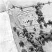
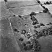
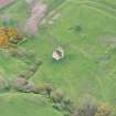
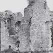
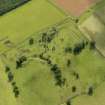
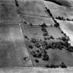
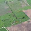
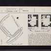
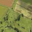
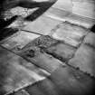
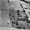
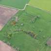
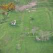
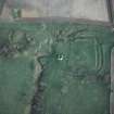
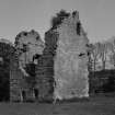
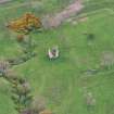
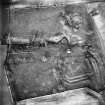
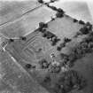
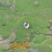
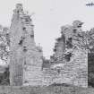
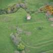
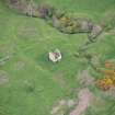
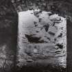
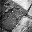
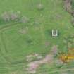
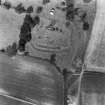
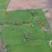
Timpendean Tower. On the western slope of Lanton Moor, about a mile and half NW of Jedburgh, the ruin of a little 16th-century tower stands beside an earthwork, obviously of earlier but otherwise of indeterminate date. The ground adjoining the site is level on the SW., falls away to the NW and rises to the SE, while to the NE it is broken by the deeply indented course of a little stream. The tower stands between this stream and the earthwork, which may originally have extended nearer the water as its NE side was evidently disturbed while the tower was in use. Plans are given in RCAHMS 1956, figs.273 and 274, and an illustration in RCAHMS 1956, fig.54.
Earthwork:
The earthwork is approached by a farm-track from the SW, along a natural shelf. As the field which contains the earthwork is entered, a broad hollow track, bounded on the NW by a bold turf-dyke and on the SE by a scarp, is seen swinging round the SE side of the earthwork and deepening as it runs down into the broken ground at the E angle. This feature is independent of the earthwork, which is roughly quadrilateral and measures internally about 270ft from NW to SE by 190ft from NE to SW. Its surviving defences comprise a single rampart and ditch on the NE side, two ramparts with a medial ditch on the NW and SE sides, and three ramparts and two ditches on the SW side, which faces the easy ground of the shelf. It is probable, however, that on the NE side an outer rampart has disappeared and on the NW side an inner one, of which latter a trace survives at the W corner. The surviving rampart on the NE side is 30ft thick and the ditch is 16ft wide; on the NW and SE sides the inner rampart is 22ft thick, the medial ditch 13ft wide, and the outer rampart 20ft thick; and on the SW side the innermost rampart is 16ft thick, the inner dith 13ft wide, the middle rampart 19ft thick, the outer ditch 11ft wide and the outermost rampart 19ft thick. The greatest depth of any of the ditches on the SW side is 6ft. The entrance is situated a little to the NW of the S angle, and it is here that the change from the double to the triple rampart occurs. Besides being somewhat broken at the W angle, each surviving rampart on the NW side shows a relatively modern break. The NE side has been much modified during the occupation of the tower. The rampart is here spread, while the ditch is visible in the SE half only, and even there almost obliterated although very clear in a National Survey air-photograph. In the NW half a turf dyke runs along the top of the spread rampart, while all trace of the ditch has disappeared. No further details can be made out in this portion of the circuit, as the immediate environs of the tower, which here adjoin it, have been drastically levelled off by builders and gardenders with the result that, in particular, the N corner has completely disappeared. There is no doubt that the earthwork just described is of earlier date than the 16th-century tower, and its subrectangular form, combined with the use of wide ditches with a rampart on either lip, suggests that the work is to be assigned to the early Middle Ages rather than to any other period.
The Tower:
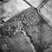
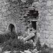
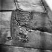
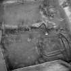
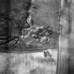
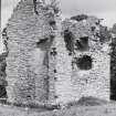
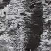
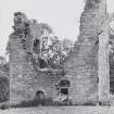
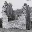
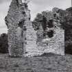
The tower stands about 15yds NE of the earthwork and is oblong on plan, measuring 29ft from NE to SW by a 24ft from NW to SE. In the 17th century it was extended in the direction of the earthwork, the uppermost of its four storeys being partly reconstructed at the same time; but at a later date the addition was entirely demolished, with the result that the present extent of the building is the same as that of the original structure. The fabric is ruinous, both side-walls being reduced to first-floor level although the gables are virtually intact. The masonry is random freestone-rubble with dressed quions.
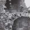
The original entrance, which has a semicircular arch checked for an outer door, faces NW, but another entrance was broken through the NE gable in the 17th century and shows a backset margin of that period. The lowest storey seems to have been lit originally by a single oval gun-loop in each wall, but of these only the two that face SW and SE respectively have survived. The one on the NW was enlarged as a window in the 17th century, while the one on the NE has been replaced by the later entrance. Of the upper-floor windows only those to the NE have survived; they all have chamfered margins. The original entrance opens into a vaulted lobby, on one side of which lies the access to the original newel-stair in the N corner of the building ; on the other side there is a locker, while a doorway immediately opposite opens into the lowest storey of the tower. This was originally a vaulted store- house ; but in the 17th century it became the kitchen, a fireplace being then formed at the SW end. The lighting was also improved and direct access was provided from the outside. The first floor had a small vaulted chamber beside the staircase, the remainder being occupied by a single room; in the first instance this room served as a hall and kitchen combined, as it was too small to permit of one end being fenced off to form the division known as "the screens". It was on this account that the lavatory basin, not infrequently found within "the screens", had to be placed within the staircase, but this basin cannot have been used in the 17th century as the entrance then formed lies immediately below its outlet. The SW gable bears the remains of a fireplace with a quirked edge-roll on its jambs, the flue being sufficiently large to be divided in two in the 17th century to serve the lowest floor also. At the W corner there are two lockers. Each of the side walls contained a single window.
The second floor has a fireplace in the NE gable evidently an insertion which has been reduced in size, while each of the side walls has had a window. The third and uppermost floor opened into the addition through two doorways flanking the chimney in the SW gable; these were necessary for communication as a 17th-century staircase which had been formed on the outer side of the gable to serve the addition was carried no higher than the second floor, The NE gable shows a scarcement, above which there are two small windows; but the main lighting of the room must have been from windows in the side walls, which no longer exist at this level. According to Nisbet (A Nisbet 1816) Timpendean was part of the estate of Bonjedward. In 1479 George Douglas of Bonjedward, with consent of his heir, granted Timpendean to a younger son, Andrew. Thus in 1540 William Douglas, son and heir of the late George Douglas of Bonjedward, received a charter which included the lands of Tympenden cum tenentibus, etc. (Reg Magni Sig Reg Scot 1984). The tower was presumably built at a later date than this.
RCAHMS 1956, visited 1 June 1932, 24, July 1945.
The remains of Timpenden Tower and earthworks are as described and planned by RCAHMS.
Resurveyed at 1/2500
Visited by OS (WDJ) 6 February 1967.
Note (1956)
(i) MISCELLANEOUS EARTHWORKS: In the absence of excavation, over eighty earthworks in the county [Roxburgh] cannot by classified either because they do not conform to recognised types or because their plans are not sufficiently distinctive. A few of these, occupying commanding positions on hilltops or the crests of ridges, are unlikely to be later than the 11th century; such are Bonchester Hill (NT51SE 8), the group of earthworks on Whitcastle Hill (NT41SW 6), and five roughly D-shaped earthworks lying within a radius of two miles between the River Teviot and the Slitrig Water- Gray Hill 2 (NT40NE 13), Birny Knowe (NT40NE 12), Crom Rig (NT40NW 16), Dodburn (No.160, ii; NT40NE 7), and Pen Sike (NT40NE 8)- which are characterised by ramparts massive in proportion to their size. The majority, however, are situated on hillsides or in the bottoms of valleys, generally below the 800 ft contour, and are probably mediaeval. Most of these lower-lying structures, of which the outstanding examples are Timpendean (NT62SW 10), Iron Castle (NT61SW 7), and Scraesburgh (NT61NE 1), were evidently designed for habitation and presumably contained wooden buildings; but a few of the simpler earthworks such as Huntly Burn (No.51) may have been enclosures for stock.
RCAHMS 1956, 50
Field Visit (1996 - 2003)
Russell Coleman managed an Historic Scotland funded project to record medieval moated sites in Scotland. Gazetteers were produced for each regional council area between 1996 and 2002 with an uncompleted overall review in 2002-03. The results of the first year of the project were published in Tayside and Fife Archaeological Journal, Volume 3 (1997).
Sbc Note
Visibility: Upstanding building, which may not be intact.
Information from Scottish Borders Council

