
Abbotrule Church


Burial Ground (17th Century), Church (Period Unknown), Font (Period Unknown)
Site Name Abbotrule Church
Classification Burial Ground (17th Century), Church (Period Unknown), Font (Period Unknown)
Canmore ID 56951
Site Number NT61SW 4
NGR NT 61162 12749
Datum OSGB36 - NGR
Permalink http://canmore.org.uk/site/56951


- Council Scottish Borders, The
- Parish Southdean
- Former Region Borders
- Former District Roxburgh
- Former County Roxburghshire
NT61SW 4 61162 12749.
(NT 6116 1275) Abbotrule Church (NR) (Remains of).
OS 6" map, Roxburghshire, (1924).
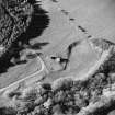
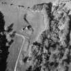
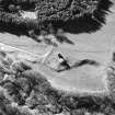
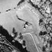
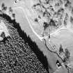
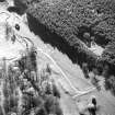
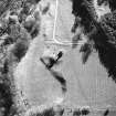
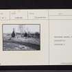
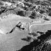
Abbotrule Church. The ruin of this church stands just within the W boundary of the parish, near the modern mansion of Abbotrule. The structure is oblong on plan, measuring 19ft from N to S by 57ft 6 in. from E to W over rubble walls varying from 2ft 4in. to 3ft in thickness. In the present condition of the fabric nothing can by gathered as to its date, both gables being densely ivy-clad, while the side walls have been largely destroyed. It is obvious, however, that the buttress supporting the inner side of the E gable is modern. A window in each gable and a doorway in the N. wall, all of which have chamfered margins, are the only surviving openings. A splayed base runs along the outside of the W gable, which is reduced in thickness from beneath the window-sill.
TOMBSTONES. Only one inscribed memorial now remains, part of a small headstone reset in the breast of the E window. It commemorates MARGAT TURNBUL, wife of RAB SPENDER, the rest of the inscription being covered by the masonry. The lettering suggest a date in the 17th century. In addition, the churchyard contains several small headstones and two recumbent slabs, now illegible or earthed over, which may date from before 1707.
Abbotrule, formerly called Rule Hervey, was a separate parish until it was suppressed in 1777. Its church belonged to Jedburgh Abbey from some date earlier than 1220; the barony was likewise acquired by the canons in 1153, and they retained it until the Reformation.(OPS 1851-5).
RCAHMS 1956, visited 23 July 1931 and 21 May 1945.
The RCAHMS description and plan for this church are correct except for orientation. All cardinal points mentioned in the text and on the plan should be reoriented through 180 degrees. There is no trace of the small headstone in the breast of the east window (this orientation is correct). Among the stones in the old graveyard is a recumbent slab dated 1686. There is no trace of the font-stone shown on the OS 25" plan at NT 6115 1270.
Visited by OS (WDJ) 8 February 1967.
Sbc Note
Visibility: Upstanding building, which may not be intact.
Information from Scottish Borders Council

