
Pricing Change
New pricing for orders of material from this site will come into place shortly. Charges for supply of digital images, digitisation on demand, prints and licensing will be altered.
Edgerston


Fort (Iron Age), Military Camp (Medieval), Settlement (Period Unassigned)
Site Name Edgerston
Classification Fort (Iron Age), Military Camp (Medieval), Settlement (Period Unassigned)
Alternative Name(s) The Camps
Canmore ID 56917
Site Number NT61SE 2
NGR NT 6798 1245
Datum OSGB36 - NGR
Permalink http://canmore.org.uk/site/56917


- Council Scottish Borders, The
- Parish Jedburgh
- Former Region Borders
- Former District Roxburgh
- Former County Roxburghshire
NT61SE 2 6798 1245.
(NT 6798 1245) Fort and Settlement (NR)
OS 25"map, (1970).
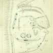
Fort and Settlement, Edgerston: A group of remains, some 2 acres in extent, occupies the crest of the high spur (750ft OD) between the Jed Water and the Kaim Burn. Extensive excavations were carried out here by the proprietrix, Mrs F S Oliver, from 1928 to 1939 and the artifacts found were donated to the NMAS in 1972-4. The plan (see RCAHMS 1956, fig.287) shows and incoherent assemblage of fragmentary structures, though three distinct occupational phases can be deduced, starting with a multivallate Early Iron Age fort, represented by ramparts A and B, with ditches D1 - D4. The ramparts are visible intermittently either as turf-covered mounds or scarps. The ditches were located by excavation at depths of between 9ins and 2ft below the turf. Occupation of the fort presumably ended with the Agricolan invasion in AD 80, and was succeeded by a settlement represented by stone-walled huts 1 - 4, and perhaps some enclosure walls; this was most probably in use post AD 139 up to 197. Medieval relics found indicate a brief occupation of the site by a military force during the Wars of Independence. (The RCAHMS gives a detailed description of the site and notes on the excavations.)
Among the relics found were: a terret, several dress-fasteners, spiral finger-rings, a penannular brooch; 2nd century Roman material including a melon bead, part of a dragonesque brooch, fragments of Samian and coarse pottery, a denarius of Trajan, struck in AD 114; native pottery, querns and whorls. The medieval objects included two pennies of Edward I, early 14th century spur-rowels, an iron arrow-head, and pottery. RCAHMS 1956, visited 1939; Proc Soc Antiq Scot 1975 (Donations); A S Robertson 1970.
The remains are generally as described and planned.
Resurveyed at 1:2500.
Visited by OS(RD) 20 February 1966.
Several bronze spiral finger-rings found in excavation.
E J MacKie 1971.
NT 679 124 A small Iron Age decorative copper-alloy mount was found by a metal-detectorist on the W slopes of the Camps below the hillfort. The mount takes the form of a dome with a short rectangular shank; its exact function is uncertain, but similar items are found as linch pin terminals. Claimed as Treasure Trove (TT 95/99) and allocated to NMS (FA 125).
F Hunter 2000
Note (31 August 2015 - 19 October 2016)
This fort is situated on the crest of a spur above the Jed Water S of Camptown. The configuration of the defences and an overlying late and Roman Iron Age settlement is complex, and confused by subsequent cultivation and a campaign of excavations conducted between 1928-39, so much so that the RCAHMS investigators who drew up a plan in 1938 and 1939 described it as an 'incoherent assemblage of fragmentary structures' (RCAHMS 1956, 225-8, no.457). Nevertheless, at its core is probably a D-shaped enclosure, its interior possibly measuring as much as 97m along the chord formed by the lip of the escarpment dropping down to the Jed Water on the W by 75m transversely (0.65ha) within two ramparts with external ditches up to 4.5m in breadth by between 1.7m and 2.4m in depth; the entrance is on the E. A shallow quarry ditch was found immediately to the rear of the inner rampart around the SE quarter, though in the equivalent position on the N it was V-shaped and 1.8m deep, and on the S a fourth ditch, some 2m deep, was located within the interior. While the RCAHMS investigators suggested the latter was concentric to the outer ditches and therefore part of a single defensive scheme, the scarp of the bank that lies immediately inside it is evidently not concentric on the SW; much more likely this belongs to a separate phase of occupation, though whether earlier or a later insertion into the interior is not clear. What is clear is that this inner enclosure is overlain by a later wall about 2.5m in thickness and still standing 1.3m in height, which appears to form a sub-rectangular enclosure occupying the N two thirds of the interior of the fort, with evidence of a smaller rectilinear enclosure and four stone-founded round-houses lying within it, at least one of which post-dated the smaller enclosure. As recorded by the RCAHMS investigators, and evidently held more widely (Childe 1946, 13-14), the construction of the walls of these enclosures was unusual, the outer incorporating two rows of upright timbers set in individual post-holes, the inner row flush with the inner face of the wall, and the outer set behind the outer wall-face; the wall of the inner enclosure was apparently constructed likewise, though in this case the posts incorporated into the inner face were set in a continuous foundation trench; the walls of the stone-founded round-houses were also thought to incorporate posts set in a continuous ring-groove beneath the core. While not impossible, excavations carried out elsewhere, particularly on rectilinear settlements in Northumberland by George Jobey, would suggest that most of these timber elements were free-standing structures that had been replaced by the walls. Finds from the excavations include a terret, three dress-fasteners, several spiral finger-rings, a penannular brooch, part of a dragonesque brooch and the rim of a vessel, all in bronze, a glass melon bead and fragments of armlets, part of a shale armlet, a denarius of Trajan, four sherds of Samian ware (Robertson 1970, Table 1), sherds of coarse pottery, one saddle quern, fragments of three beehive querns, two crucibles and several spindle whorls and hammerstones; the majority of these finds probably relate to the overlying settlement rather than the fort (Proc Soc Antiq Scot 105, 1972-4, 319, no.17). More recently a small Iron Age copper alloy mount was found on the slope below the fort on the W (Hunter 2000).
Information from An Atlas of Hillforts of Great Britain and Ireland – 19 October 2016. Atlas of Hillforts SC3371
Sbc Note
Visibility: This site has been excavated.
Information from Scottish Borders Council

