
Martinlee Sike


Enclosure (Prehistoric), Hut Circle (Prehistoric)
Site Name Martinlee Sike
Classification Enclosure (Prehistoric), Hut Circle (Prehistoric)
Canmore ID 56812
Site Number NT60NE 7
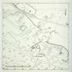
NGR NT 6597 0793
Datum OSGB36 - NGR
Permalink http://canmore.org.uk/site/56812


- Council Scottish Borders, The
- Parish Southdean
- Former Region Borders
- Former District Roxburgh
- Former County Roxburghshire
NT60NE 7 6597 0793.
(NT 6597 0793) Enclosure (NR)
OS 6"map, (1963).
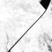
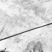
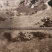
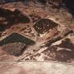
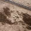
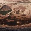
This oval enclosure measures 55' x 44' within a ruined boulder-faced earthen wall, 5'6" thick but not more than 1' high. The interior is featureless except for two secondary quarries, one of which has cut through the line of the wall. Adjoining the enclosure on the S is a circular court, 23' in diameter within an earthen bank, 3' thick. There are two entrances, one on the N communicating with the enclosure, and another in the SE arc. A few yards S of this court there is a segment of an earthen bank, 50' long and 10' thick, with an external ditch; a circular scooped court, 20' in diameter, lies immediately SW of the enclosure.
RCAHMS 1956, visited 1948.
This enclosure is as described above.
Visited by OS(JLD) 10 October 1960.
This feature, a homestead, is as described.
Visited by OS(IA) 13 July 1973.
This enclosure, generally as described by the RCAHMS, is too poorly preserved for positive classification; however the scooped courts and the SW aspect suggest that it may be the remains of a homestead.
Visited by OS(TRG) 20 September 1976.
Field Visit (24 February 1992)
This homestead is situated in gently-sloping rough pasture about 100m to the E of the Martinlee Sike, immediately N of the public road from Carter Bar to Hawick. The homestead comprises an enclosure with a hut-circle on a terrace to the SE and a platform, possibly for a second building, on the SSW. The enclosure is sub-circular in plan and measures some 14m across within rubble-faced walls 1.6m in thickness and up to 0.5m in height with an entrance on the NNW; its interior is scooped into the slope of the ground on the SE and has been subsequently quarried on the N, partly destroying the wall of the enclosure. The hut-circle measures 7m in diameter within a stone-faced bank 1m in thickness and up to 0.5m in height with an entrance on the ENE and what may be a second on the NW, opening onto the enclosure. An arc of a bank, spread to 3.3m in thickness and 0.4m in height, runs around the S and SE of the hut-circle. The hut-platform opens onto the SSW side of the enclosure and measures 6.7m from ENE to WSW by 5.6m transversely. (ROX92 52-4)
Visited by RCAHMS (PJD) 24 February 1992.
Sbc Note
Visibility: This is an upstanding earthwork or monument.
Information from Scottish Borders Council

