
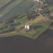
Kingston, Fenton Tower


Tower House (Medieval)
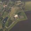
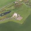
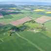
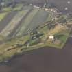
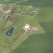
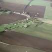
Site Name Kingston, Fenton Tower
Classification Tower House (Medieval)
Alternative Name(s) Kingston Hill
Canmore ID 56739
Site Number NT58SW 10
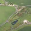
NGR NT 54334 82095
Datum OSGB36 - NGR
Permalink http://canmore.org.uk/site/56739


- Council East Lothian
- Parish North Berwick
- Former Region Lothian
- Former District East Lothian
- Former County East Lothian
NT58SW 10 5434 8209
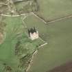
(NT 5434 8209) Fenton Tower (NR) (remains of)
OS 6" map (1968)
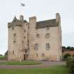
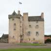
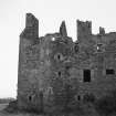
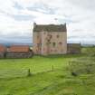
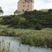
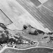
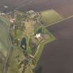
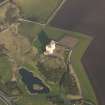
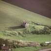
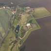
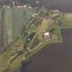
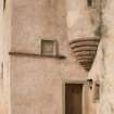
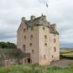
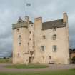
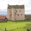
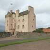
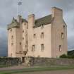
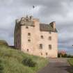
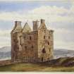
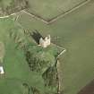
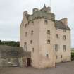
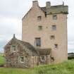
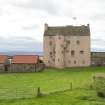
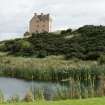
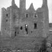
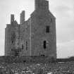
The 16th century remains of Fenton Tower comprise a main block measuring externally 57' by 23 1/2' with a S wing which measures 13' by 17'. The walls are 4' thick. The exterior of the structure is in an excellent state of preservation.
RCAHMS 1924; N Tranter 1962
Fenton Tower is as described.
Visited by OS (RDL) 14 November 1962 and (JP) 7 July 1975.
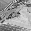
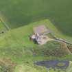
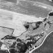
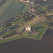
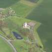
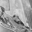
NT 5434 8209 A programme of archaeological investigation and building survey was carried out at Fenton Tower. The aims were to record the building structure through survey and excavation, to produce a record of the building prior to structural stabilisation, and to determine the nature and extent of surviving archaeological deposits within the tower and in its immediate vicinity. The results show that a great deal of remodelling of the areas immediately outside the tower has resulted in the loss of archaeological deposits. Internal trenches failed to provide any firm dating evidence for the construction phase of the tower which is reputed to date to the early 17th century. External excavations revealed a series of features that relate to the position of an external building and curtain wall. Based on the archaeological evidence found in the basement, it appears that this was used as a byre, probably during the 19th century.
The building survey revealed a relatively straightforward sequence of construction, adaptation and abandonment. Post-excavation work will include dendrochronological dating to provide felling dates for a large collection of oak timber and to determine if this material was imported from Scandinavia or Russia.
Report to be lodged with the NMRS.
Sponsor: Fenton Tower Ltd.
M Cressey, D Alexander and I Suddaby 2001.
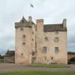
Fenton Tower has now been restored.
(Undated0 information in NMRS..
Field Visit (8 July 1913)
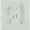
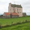
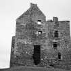
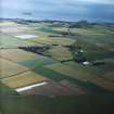
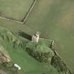
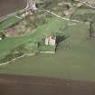
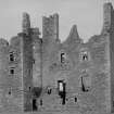
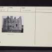
The ruin of this tower, which dates from the end of the 16th century, occupies a conspicuous position on the rising ground of Kingston Hill two miles south of North Berwick. The structure is built on an L-plan (fig.107), with the main block lying east and west and the short wing projecting southwards in alinement with the west gable. This main block contained three storeys and an attic floor, the latter lit by dormer windows. The wing terminated some 40 feet above the ground in turrets at the southern angles, all traces of which, save the corbellings that bore them, have disappeared. The lowest storey of this portion is occupied by the main staircase, which ascended only to the first floor. Above this level are three storeys, each of one apartment, reached from a turret staircase corbelled out in the re-entering angle. From the north wall of the main block a semicircular tower projects and contains between ground and first floor levels a small circular staircase (originally the only internal access between these levels) and above the latter level, three floors, each of a single circular chamber only 6 feet in diameter. These were entered from a turret stair corbelled out in the east re-entering angle. In the corresponding angle on the west a garderobe is corbelled out but at a higher level.
The elevations are plain and relieved only by the disposition of corbelled turrets; the walling is of rubble uncoursed, at one time rough cast, with freestone quoins, jambs and corbellings. The latter are well proportioned, with a bold contour, and have been carefully wrought. The windows and other apertures of any size have relieving arches. The first floor windows facing south have been cut down at a subsequent period apparently to permit of an alteration on the floor levels. The only moulding employed seems to be the edge roll, and that is sparingly used.
The structure (fig. 19 [SC 1127002]) stands fairly complete to the wall heads but has two rents in the south wall between the ground and first floors.
The basement is divided unequally by across partition, which is carried up through all the storeys, into two chambers, which have evidently had vaulted ceilings. In this partition must have been a door between the chambers, but in addition the smaller chamber on the east communicated with the upper floor by the circular staircase on the north, and the larger chamber with the exterior by a doorway in the west gable. The door between this chamber and the main staircase does not appear to have been originally intended, and the slapping in the east gable of the smaller room is comparatively modern.
The windows lighting these rooms are small, with 10 inch daylights widening internally to 3 feet between the jambs, and are disposed in the lateral walls. In the west gable, on either side of the entrance doorway is a cupboard 2 feet 9 inches broad. The basement apartments are 16 feet broad by 30 feet 8 inches and 16 feet 2 inches long respectively.
The staircases are ruinous, and the vaults of the lowest apartments have fallen in, rendering the upper floors inaccessible, but on the first floor the arrangement of the rooms below is repeated. The larger apartment would be the hall, the smaller a private room. On the floors above are three apartments, the western portion being divided by a partition. These were reached from the turret stairs on north and south, which also communicated with the little rooms in the wing and the north tower.
The entrance to the wing is placed in there-entering angle below the corbelling of the turret staircase. The doorway has an edge-roll on the lintel, above which is an empty recess for an armorial panel, which is stated in Croall's Sketches of East Lothian, to have borne the arms of the Carmichael family with the initials J C for John Carmichael, and the date 1577 (? see below). The staircase is wide and circular on plan and was lit by a window, now built up, in the south wall.
The main block measures externally 57 feet by 23 ½ feet. The wing projects 13 feet southwards and is 17 feet broad. The walls are 4 feet thick.
The exterior of the structure is wonderfully complete, considering that it has received little or no attention of late years, but, if left untended much longer, it soon will fall into a ruinous condition.
CRUCIFORM CARVING [NT58SW 7]. A square dressed block of yellowish freestone is built into a stone wall on Kingston Hill within 200 yards of Fenton Tower. It measures 10 ½ inches by 12 inches on face and bears an incised Maltese cross, within the arms of which is the date 1607 (1).
HISTORICAL NOTE. In 1587 John Carmichael of Carmichael, afterwards Sir John, and his wife Margaret Douglas had a grant of the lands of East Fentoun commonly called 'Fentountoure' or Over Sydserf with fortalice and manor, etc., which had come into the King's hands by the forfeiture of Patrick Whytelaw of that place (2). Apparently there was a tower in Whytelaw's time, as might be expected (3).
RCAHMS 1924, visited 8 July 1913.
(1) Cf. Proc. Soc. Ant. Scot. xli., 432 ; (2) R.M.S. s.a. No. 1348; (3) Act. Parl. Scot. iii., p. 603.
Watching Brief (1 April 2019 - 30 April 2019)
NT 54365 82102 A watching brief was carried out, in April 2019, during ground breaking works for the construction of ancillary accommodation at Fenton Tower. No archaeological features or deposits were uncovered.
Archive: NRHE (intended)
Funder: Fenton Brunt Estate
John Musgrove - CFA Archaeology Ltd
(Source: DES Vol 20)
OASIS ID: cfaarcha1-350580
Archaeological Evaluation (March 2022)
NT 54394 82130 (centred) A trial trenching evaluation covering
112.5m² was undertaken, in March 2022, at Fenton Tower, Kingston (Canmore ID: 56739) in advance of development for a new lodge. A single field boundary/agricultural ditch was identified in Trench 2.
No further archaeological features, deposits or artefacts were identified.
Archive: NRHE (intended) Funder: Fenton Tower PLC
Harry Francis – CFA Archaeology Ltd
(Source: DES Volume 23)
OASIS ID: cfaarcha1-436209
Note
Fenton Tower was restored between 1998 - 2002 by Groves-Raines Architects and photographed for the HES Listed Buildings Area survey in 2017.

