|
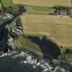
Photographs and Off-line Digital Images |
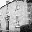
EL 6266 |
List C Survey |
View from NE. |
1975 |
Item Level |
|
|
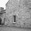
Photographs and Off-line Digital Images |
EL 6267 |
List C Survey |
View from SW. |
1975 |
Item Level |
|
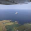 |
On-line Digital Images |
DP 020075 |
RCAHMS Aerial Photography Digital |
General oblique aerial view centred on the remains of the castle and dovecot with the farmhouses and farmsteadings adjacent and Bass Rock in the distance, taken from the S. |
25/7/2006 |
Item Level |
|
 |
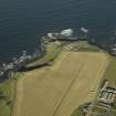
On-line Digital Images |
DP 036143 |
RCAHMS Aerial Photography Digital |
Oblique aerial view centred on the radar station/research establishment, taken from the N. |
10/9/2007 |
Item Level |
|
 |
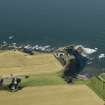
On-line Digital Images |
DP 036147 |
RCAHMS Aerial Photography Digital |
Oblique aerial view centred on the radar station/research establishment with the farmstead adjacent, taken from the W. |
10/9/2007 |
Item Level |
|
 |
On-line Digital Images |
DP 036150 |
RCAHMS Aerial Photography Digital |
Oblique aerial view centred on thefarmstead with the radar station/research establishment adjacent, taken from the S. |
10/9/2007 |
Item Level |
|
 |
On-line Digital Images |
SC 1644324 |
List C Survey |
View from NE. |
1975 |
Item Level |
|
 |
On-line Digital Images |
SC 1644325 |
List C Survey |
View from SW. |
1975 |
Item Level |
|
 |
On-line Digital Images |
SC 2451531 |
Records of the Ordnance Survey, Southampton, Hampshire, England |
Castleton Farmhouse, NT58SE 60, Ordnance Survey index card, Recto |
c. 1958 |
Item Level |
|


